Pulletop Bushfire
| Pulletop Bushfire | |
|---|---|
 | |
| Location | Pulletop, New South Wales |
| Coordinates | 35°30′39″S 147°26′48″E / 35.510833°S 147.446667°E |
| Statistics | |
| Date(s) | 6 February 2006 – ? |
| Map | |
 | |
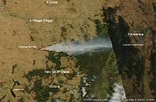
The Pulletop Bushfire started on the 6 February 2006 in hot dry and windy weather conditions about 30 km southeast of Wagga Wagga, New South Wales.[1] The fire was thought to have been started by sparks from a tractor on a property at Pulletop which quickly got out of control. New South Wales Rural Fire Service declared a bushfire emergency and the Hume Highway was closed late in the afternoon with fears that the fire would threaten the towns of Humula, Book Book, Livingstone and Kyeamba after 10 km² of farmland was burnt.[1][2] 7 February 2006 milder conditions help firefighters to control the fire burning in inaccessible country.[3]
Over 90 km² of farmland burnt[4]
References
- 1 2 "RFS declares bushfire emergency". Australian Broadcasting Corporation. ABC News. 2006-02-06. Retrieved 2009-02-10.
- ↑ "Blue Mountains Firefighters dispatched to Wagga". New South Wales Government. New South Wales Rural Fire Service. 2006-02-07. Retrieved 2009-02-10.
- ↑ "Mild weather helps battle against Pulletop blaze". Australian Broadcasting Corporation. ABC News. 2006-02-07. Retrieved 2009-02-10.
- ↑ "Bushfire prompts natural disaster declaration". Australian Broadcasting Corporation. ABC News. 2006-02-15. Retrieved 2009-02-10.
External links
| Wikimedia Commons has media related to Pulletop Bushfire. |
- Firefighters still tackling big south-western blaze. 07/02/2006. ABC News Online
- Bushfire closes Hume Highway. 07/02/2006. ABC News Online
- Firefighters hope to contain south-west blaze. 08/02/2006. ABC News Online
- NSW RFS Pulletop fire photos
This article is issued from Wikipedia - version of the 9/1/2016. The text is available under the Creative Commons Attribution/Share Alike but additional terms may apply for the media files.