Puncak Mandala
| Puncak Mandala | |
|---|---|
| Julianatop | |
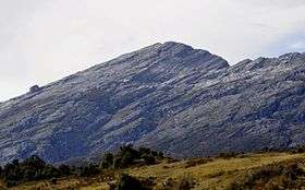 Puncak Mandala from northwest | |
| Highest point | |
| Elevation | 4,760 m (15,620 ft) [1] |
| Prominence | 2,760 m (9,060 ft) [1] |
| Listing |
Seven Second Summits Ultra Ribu |
| Coordinates | 4°42′31″S 140°17′21″E / 4.70861°S 140.28917°ECoordinates: 4°42′31″S 140°17′21″E / 4.70861°S 140.28917°E |
| Geography | |
 Puncak Mandala | |
| Parent range | Jayawijaya (Orange) Range |
| Climbing | |
| First ascent |
9 September 1959 by Herman Verstappen, Arthur Escher, Max Tissing, Jan de Wijn & Piet ter Laag [2] |
Puncak Mandala (until 1963 Julianatop or Juliana Peak) is a mountain located in Papua, Indonesia. At 4,760 metres (15,617 ft), it is the highest point of the Jayawijaya (Orange) Range. Following Mount Carstensz (4884 m) 350 km to the west, Mandala is the second highest freestanding mountain of Oceania, Australasia, New Guinea and Indonesia.[3][4]
Geology
Mandala is one of the three high massifs of Western New Guinea, together with the Cartstensz and Trikora complexes.[4] This peak used to have an ice cap, but it was last seen in 1989 and by 2003 it was totally gone.[4] Based on the Shuttle Radar Topography Mission data, this peak is likely higher than Puncak Trikora, which lost its icecap in about 1960.[4]
Ascents
Climbers from the Dutch 1959 expedition to the Star Mountains the reached the peak of Puncak Mandala on 9 September.[5]
See also
- List of Southeast Asian mountains
- List of highest mountains in Oceania
- List of Ultras of Malay Archipelago
- List of highest mountains of New Guinea
References
- 1 2 "Mountains of the Indonesian Archipelago" Peaklist.org. Retrieved 7 November 2011.
- ↑ Video report of first ascent (in Dutch)
- ↑ List of highest mountains in Indonesia at the Gunung Baggingsite.
- 1 2 3 4 "Puncak Mandala, Indonesia". Peakbagger.com. Retrieved November 8, 2011.
- ↑ Jansen Hendriks, Gerda. "Sterrengebergte" (in Dutch). NPO. Retrieved 30 August 2016.
Further reading
- "Puncak Mandala" at GunungBagging.com