Pungwe River
| Pungwe River | |
|---|---|
| Native name | Rio Púngoè or Rio Púnguè |
| Country | Zimbabwe and Mozambique |
| Basin | |
| Main source |
Eastern Highlands (Zimbabwe) 1,500 metres (4,900 ft) |
| River mouth |
Indian Ocean: Beira 0 metres (0 ft) 19°51′55″S 34°49′07″E / 19.865278°S 34.818611°ECoordinates: 19°51′55″S 34°49′07″E / 19.865278°S 34.818611°E |
| Basin size | 31,151 km2 (12,027 sq mi) |
| Physical characteristics | |
| Length | 400 km (250 mi) |
| Discharge | |
| Features | |
| Tributaries |
|
Pungwe River (Portuguese: Rio Púngoè or Rio Púnguè[3]) is a 400 km (250 mi) long river in Zimbabwe and Mozambique.[1][2] It rises below Mount Nyangani in the Eastern Highlands of Zimbabwe and then flows eastward through the Manica and Sofala provinces of Mozambique. It then empties into the Mozambique Channel at Beira, forming a large estuary.[2] It is one of the major rivers of Mozambique and often causes floods.[1][2]
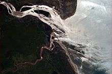

Pungwe basin
Administratively, the Pungwe Basin covers parts of Sofala and Manica provinces in Mozambique, and a large part of Mutasa District in Zimbabwe. A small portion of the basin in Zimbabwe falls in Nyanga District.[2] As of 2003, the basin's population in Mozambique is estimated at about 1,104,000 people and that for Zimbabwe at 96,000 people.[2]
Water supply systems
Beira metropolitan area in Mozambique receives its water supply from the Pungwe River. The 2004 water demand from the Beira/Dondo water supply, which included the Mutua and Mafambisse areas, was estimated at 25,339 cubic metres (894,800 cu ft)/day.
The city of Mutare is supplied from the Pungwe River through an inter-catchment transfer facility. The quantities transferred to are limited to a maximum of 0.7 cubic metres (25 cu ft)/second by the provisions of a water permit and system design. In addition, on 27 September 1995, it was agreed at a meeting of the Mozambican and Zimbabwean ministers responsible for water affairs that water could be abstracted from the Pungwe River to supply the city of Mutare, with an upper limit of 1 cubic metre (35 cu ft)/second. Consequently, a fixed abstraction of 60,480 cubic metres (2,136,000 cu ft) per day by Mutare city has been adopted as water demand from the Pungwe River. The Mutasa Rural District is also expected to draw water from the Pungwe pipeline to supply villages along its route.[2]
Climate change is predicted to lead to about 10% reduction in annual rainfall. This implies decreased river flow and available water for the Pungwe River basin, with possibly severe consequences for agricultural production. While the between-year variability in flow is not predicted to change significantly, within-year variability is expected to increase. This will worsen both floods and droughts.[1]
References
- 1 2 3 4 Andersson, Lotta; Samuelsson, Patrick; Kjellström, Erik (2011). "Assessment of climate change impact on water resources in the Pungwe river basin". Tellus A. 63 (1): 138–157. doi:10.1111/j.1600-0870.2010.00480.x.
- 1 2 3 4 5 6 7 SWECO & Associates (April 2004). The Pungwe River Monograph. Main Report. SWECO Project No: 1150447 (PDF). Government of the Republic of Mozambique; Government of the Republic of Zimbabwe; Swedish International Development Cooperation Agency (Sida). 64 pp.
- ↑ "GeoNames Search". Geographic Names Database. National Geospatial-Intelligence Agency, USA. Retrieved 19 October 2016.