Mutare
| Mutare | |||
|---|---|---|---|
| City | |||
|
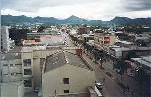
Aerial view of Central Mutare (2001) | |||
| |||
| Nickname(s): Gateway to the Eastern Highlands, Zimbabwe's Gateway to the Sea | |||
| Motto: Justice and Freedom | |||
 Mutare | |||
| Coordinates: 18°58′S 32°38′E / 18.967°S 32.633°ECoordinates: 18°58′S 32°38′E / 18.967°S 32.633°E | |||
| Country |
| ||
| Province | Manicaland | ||
| District | Mutare | ||
| Founded | 1897 | ||
| Government | |||
| • Mayor | Tatenda Nhamarare | ||
| Elevation | 1,120 m (3,675 ft) | ||
| Population (2012)Census Results in Brief | |||
| • Total | 188 243 | ||
| estimated | |||
| Time zone | Central Africa Time (UTC+2) | ||
| Climate | Cwa | ||
| Website | City of Mutare | ||
Mutare (known as Umtali until 1983[1]) is the fourth largest city in Zimbabwe, with an urban population of approximately 188,243 and rural population of approximately 260,567.[2] It is the capital of Manicaland province.
History

Although the city was founded in the late nineteenth century, the region has a long history of trading caravans passing through on the way to the Indian Ocean, from ports such as Sofala, to inland settlements, such as Great Zimbabwe. Zimbabwe is also renowned for its soapstone carvings and figurines which are evidence of these trade routes, dating as far back as the late African Iron Age (c. 900 AD) right up to the colonial period. A large hoard of soapstone carvings, jewellery, weapons, sherds and other objects were found in the vicinity of Mutare at the beginning of the twentieth century - they were later donated by the trustees of Cecil Rhodes to the British Museum in 1905.[3] The soapstone figures, which are both anthropomorphic and zoomorphic, may have been part of a votive offering, as they were discovered near what appeared to be an altar by the British archaeologist E M Andrews.
Mutare was founded in 1897 as a fort, about 8 km from the border with Mozambique, and is just 290 km from the Mozambican port of Beira, earning Mutare the title of "Zimbabwe's Gateway to the Sea". It is sometimes also called "Gateway to the Eastern Highlands". Many Zimbabwean locals refer to it as 'Kumakomoyo' (place of many mountains). There is a border railway station on the railway line from Harare to Beira with a railways mechanical workshop.
The area was the site of Chief Mutasa's kraal. In 1890 A.R. Coquhoun was given concessionary rights and Fort Umtali (the fort later became Mutare) was established between the Tsambe and Mutare Rivers. The word mutare originates from the word 'Utare' meaning iron (or possibly meaning gold). The name was probably given to the river as a result of gold being discovered in the Penhalonga valley through which the Mutare River runs.
In 1891 the location was moved to a site now known as Old Mutare, about 14 km north of the city centre. In 1896 the construction of the railway between Beira and Bulawayo led to the town being moved a third time so that it was closer to the railway line – compensation was paid by the British South Africa Company to the townspeople for the cost of moving. The town was proclaimed a municipality in 1914 and in 1971 it was granted city status. The name was officially changed from Umtali to Mutare in 1982.
The city had a tramway from January 26, 1897 to May 23, 1921 which transported passengers from the Railway station up to the (then Umtali Club) now Mutare Club. The Tramway was at the centre of Main Street where the palm trees now stand.[4]
There were plans to set up a Stock Exchange in Umtali. The main post office was at the site where CABS centre now stands.
Climate
Despite its tropical location, the city has a temperate climate. The average annual temperature is 19 °C, surprisingly low for its moderate altitude (about the same as Harare which is 360 metres higher.) This is due to its sheltered position against the mountain ridge of Cecil Kop which encourages cool breezes from lower altitude to the east and south. The coldest month is July (minimum 6 °C and maximum 20 °C) and the hottest month is October (minimum 16 °C and maximum 32 °C). The annual rainfall is 818 mm. Rain falls mostly in the months December to February although heavy showers are possible before and after this period. The wettest month on record was January 1926 which received 580 mm while January 1991 received only 24 mm.
| Climate data for Mutare | |||||||||||||
|---|---|---|---|---|---|---|---|---|---|---|---|---|---|
| Month | Jan | Feb | Mar | Apr | May | Jun | Jul | Aug | Sep | Oct | Nov | Dec | Year |
| Average high °C (°F) | 27.6 (81.7) |
26.8 (80.2) |
26.3 (79.3) |
25.2 (77.4) |
23.7 (74.7) |
21.4 (70.5) |
21.2 (70.2) |
23.2 (73.8) |
26.1 (79) |
27.0 (80.6) |
27.5 (81.5) |
27.1 (80.8) |
25.3 (77.5) |
| Average low °C (°F) | 17.5 (63.5) |
16.3 (61.3) |
15.6 (60.1) |
13.9 (57) |
10.6 (51.1) |
8.0 (46.4) |
7.6 (45.7) |
9.3 (48.7) |
12.2 (54) |
14.6 (58.3) |
16.1 (61) |
16.9 (62.4) |
13.2 (55.8) |
| Average rainfall mm (inches) | 153.5 (6.043) |
164.5 (6.476) |
88.4 (3.48) |
31.8 (1.252) |
12.4 (0.488) |
8.9 (0.35) |
5.8 (0.228) |
6.0 (0.236) |
20.2 (0.795) |
45.9 (1.807) |
86.4 (3.402) |
167.0 (6.575) |
790.8 (31.134) |
| Average rainy days | 13 | 11 | 10 | 4 | 3 | 2 | 2 | 2 | 2 | 5 | 8 | 12 | 74 |
| Source: World Meteorological Organization[5] | |||||||||||||
Location
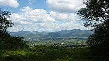
The town lies north of the Bvumba Mountains and south of the Imbeza Valley. Christmas Pass is a mountain pass that leads into the city from the west. The pass was so named by some of the colonial pioneers who camped at the foot of the pass on Christmas Day 1890.
Mutare is home to the Mutare Museum, the Utopia House Museum dedicated to Kingsley Fairbridge, the National Gallery of Zimbabwe, Murahwa Hill, known for its rock paintings and Iron Age village, Cross Kopje with a memorial to Zimbabweans and Mozambicans killed in World War I and a nature reserve Cecil Kopje and Tigers Kloof. The Mutare Boys' High Chapel was constructed in honour of former Old boys who perished in World War II, situated on a hilly knoll at Mutare Boys High (then Umtali Boys High).
Mutare is served by rail with daily passenger and freight links to the towns of Nyazura, Rusape and Harare.
There are two small aerodromes; the smallest is at Mutare Provincial Hospital a very small light aircraft strip for emergency evacuation (now defunct) and a light plane aerodrome in Sakubva near Mutare Teachers College. There is yet a third airport constructed in Chiadzwa to carry diamonds for processing in Harare.
Population
The population is predominantly Shona, the majority of them speaking the Manyika dialect. Manyika people are locally known as Samanyikas. According to the 2012 preliminary census data, Mutare has a population of 188 243 ; 88 957 being male and 99 286 females . This marks a rapid increase from a population of 69,621 in 1982 and 131,367 in 1992.[6]
Suburbs
Mutare, like most cities in Zimbabwe, classifies residential suburbs according to the population density.
The most upscale suburbs (low-density suburbs) such as Murambi,Fairbridge Park (named after the founder of the present site of Mutare), Morningside and Tiger's Kloof are located on the north end of the city along the foothills, while Palmerston, Darlington, Greenside, Greenside extension and Bordervale are east of the city center, near the border with Mozambique.
In the west are the medium-density suburbs of Yeovil, Westlea and Florida (and Train Houses), as well as the high density suburb of Chikanga, which was constructed in phases (Phase 1; 2; 3) beginning in the late eighties.
Further west of Chikanga lies the Garikai/Hlalani Kuhle and Hobhouse. South of the railway track lies the high-density suburb of Sakubva, which contains nearly half of the city's population despite an area of less than four square miles. Sakubva is considered to be the poorest of Mutare's suburbs, and its economy is centred around a large outdoor food and flea market-and the "Musika weHuku" (The chicken market).
A few miles to the south, hidden from view from the rest of the city by a series of hills, is the high-density suburb of Dangamvura. The low-density areas of Weirmouth (Plots) and Fern valley are also on the southern outskirts of the city; in these areas residential lots exceed an acre, and market gardening is an economic activity.In fern valley there is also the new state university,Manicaland college of applied Sciences.
Further to the south along the road to Masvingo and outside the city limits is the high-density town of Zimunya. Mutare's main industrial areas are south of the railway and west of Sakubva, although there is also some light industry just east of the southern part of the city centre at "Greenmarket" and surrounding areas.
These are some of the suburbs of Mutare.
| Region | Suburbs |
|---|---|
| Northern (North of the railway line) | Murambi;Fairbridge Park; Morningside; Tiger's Kloof; Palmerston; Avenues; Utopia; Darlington; Greenside; Greenside extension (built on former border security zone) Yeovil; Westlea; Florida, extension; Chikanga Phases 1,2 and 3 (Formerly Norris Farmland); Toronto; Bordervale. |
| Southern (South of the railway line) | Sakubva; Dangamvura; St Josephs Park-chikanga extension, Weirmouth; Fern valley; Zimunya; HobHouse, extension; Natview Park, Mai Maria, Gimboki, Garikai Hlalani Kuhle. |
Education
Mutare is home to schools and tertiary institutions:
Primary education
- Baring Primary School
- Chancellor Junior School
- Chikanga Primary School
- Cross Kopje Junior School
- Chirovakamwe
- Dangamvura Primary School
- Hillcrest Preparatory School (Private school)
- Mutanda Primary School
- Mutare Junior School
- New Dangare Primary School
- Rujeko Primary School
- Sakubva Primary School
- Murahwa Hill Primary School
- St Joseph's Primary School
- Sheni Primary School
- Zamba Primary School
- Zimunya Primary School
- Sacred Heart Primary School
- Chisamba Primary School
- Matika Primary School
- Joshua Dhube Primary School
- Zhawari Primary School
- Dangare primary School
- Mutukwa primary School
- Hartzell Central Primary School
Secondary education / high school education
- Hartzell High School
- Chikanga High School
- Dangamvura High School
- Elise Gledhill High School
- Hillcrest College
- Mutare Boys' High School
- Mutare Girls' High School
- Nyamauru High School
- Sakubva High School (Dangwe)
- Sakubva High 2 School (Rushingo)
- St Dominics High Mutare
- St Josephs High School
- St Mary's High Chikanga
There are a number of private colleges around the city.
Tertiary institutions
- Africa University, a pan-African United Methodist funded university of about 5,000 students
- Marymount Teachers' College
- Mutare Teachers College
- Mutare Polytechnic
- Magamba vocational training
- Fern Valley University -under consideration for construction for a long time
Economy
The main activities of the area are citrus farming, mining (The city's name is derived from "metal") and forestry. Two of the largest food producers in Zimbabwe, Cairns Foods and Tanganda Tea, operate in Mutare.
Mining includes gold at Redwing Mine, Penhalonga and some smaller mines, diamonds in Marange and gravel quarries around the city. There are a number of forestry companies including The Wattle Company, Allied Timbers formerly FCZ,Border Timbers and Timcon Investments .The main timber products include rough sawn timber, wattle bark, charcoal, various doors and frames and mouldings. The major timber produced is pine, sydney blue gum, black wattle, and some hardwoods on a smaller scale.
Notable residents
- Professor Governor Mambo Mupepi, born in Mutare and went to Dangare Primary School, great goalkeeper and athlete brought MASA and SASA home 1967 Now teaches in the USA and writes much including "British Imperialism in Zimbabwe: Narrating the Organizational Development of the First Chimurenga 1883–1904", "Creating High Impact Organization","Unlocking entrepreneurial capability in Zimbabwe" and many more.
- C.W.Mercer, a British author who wrote under the pen name Dornford Yates; lived near the city from 1948 until his death in 1960
- Donal Lamont, Catholic bishop of Umtali/Mutare 1957–82, an outspoken opponent of the Ian Smith government; expelled from Rhodesia in 1977 after a high-profile trial
- Douglas Rogers, a journalist and memoirist was born in the city in 1968 and raised there
- Arthur Mutambara, became Deputy Prime Minister of Zimbabwe on 11 February 2009, under the September 2008 power-sharing agreement
- Onismor Bhasera, soccer star now playing for Plymouth Argyle Football Club in England
- Tichafa Samuel Parirenyatwa Dr. (1927–1962), Zimbabwe's first black medical.
- Herbert Chitepo (15 June 1923 – 18 March 1975, Zimbabwe's first black lawyer and Chairman of ZANU July 1963 – 18 March 1975
- Supa Mandiwanzira, media personality and politician. He became the deputy minister in the ministry of Information, Media and Broadcasting Services on 10 September 2013.
- Edgar Tekere (1937–2011), nicknamed "2 Boy", a prominent politician
- Genius Chidzikwe, a tennis player
- Trevor Madondo (1976–2001), one of the first black cricket players in Zimbabwe
- Lawrence Mudehwe, the first Executive Mayor to be elected as an independent candidate in Zimbabwe; served for two terms
- Bjorn Mordt (born 1978), cricketer
- Nathaniel Mlambo: Media personality, broadcast journalist and first news editor of Mutare's first ever metro radio station Diamond FM 103.8
- Daniel Baradza (born c. 1973), sculptor
- Blessing Makunike (24 January 1977 – 13 March 2004), a Zimbabwean international football player
- Chiwoniso Maraire (5 March 1976 – 24 July 2013), an accomplished Mbira player, singer, songwriter, and exponent of Zimbabwean mbira music
- Willard Katsande (Kaizer Chiefs and Warriors midfielder)
- Onismor Bhasera (Bidvest Wits and Warriors leftback)
- Washington Arubi (Tuks and warriors Goalkeeper)
- David Pritchard Born in Kendal, Cumbria, UK 16 October 1945 died in Mutare 9th September 2000. General Manager of Pritchard Diesels and Managing Director of Trakrite Services. Philanthropist and actively in service to the community of Mutare.
- Morgan Tsvangirai
∗Farai Tumbare (Legendary Zimbabwean Basketball Player)
- Tinotenda Mbiri Kanayi "Tino" Mawoyo 8 January 1986- (Zimbabwean cricketer) Scored a brilliant 163* v Pakistan in Bulawayo, September 2011
- Opa Muchinguri
- Lazarus Muhoni (Former warriors international football player and formerly with ZUPCO, Buffaloes, Black Rhinos, Dynamos, CAPS)
- Nelson Bandura (Tanganda and Mamelodi Sundowns Football Clubs)
- Kennias Marange (Former FIFA panel referee)
- Trevor Jones Lovelace Saruwaka Mutasa Central MP
- Maxwell Chitunhu( Computer Scientist)
- David Makwerere (Academic)
- Pamela Machakanja (Professor in Peace and Conflict Studies)
- Phillip Nyasha Fungurai (Academic - Peace, Governance and Human Rights)
- Rukudzo Murapa (Former Africa University Vice-Chancellor)
- Taka Mutunhu (Banker)
- Chris Mushohwe, politician
- Donald Tiripano, Zimbabwean cricketer
- Mike Hitchman
- Layman Gunda (The youngest Disc Jockey in the Province)
- Ryan Trymore Muratu, popular cake artist in southern Africa
- Major Mashayamhara (Animal scientist)
- [Moses Semwayo] Philanthropist,founder of Semwayo School of Sewing
- [Richard Nyamugama Sr 1940-2012] Renowned educationist studied at Old Mutare Mission, Nyadire Teachers College where as a member of the college Choir they recorded Mazuva Ekupedzisira on vinyl in 1968 one the earliest recordings of choral music by Africans and later the University of Zimbabwe where he completed his B.Ed, he was headmaster at Munyarari, Matanda,Chipindirwe,Dzobo,Vengere and lastly Zimunya he also taught during the war of liberation years at Maruta and Nyague in Mrewa, Chiriseri (Masembura),Eagle in Marondera Later Became DEO Chipinge south taught many luminaries Notably writer and UZ academic Musaemura Zimunya and many more. He was an active full member of the United Methodist Church and was the pioneer of the Chibuwe circuit of the church in 1998 before retiring to his rural home in Bocha
Twin towns – Sister cities
References
- ↑ Names (Alteration) Act Chapter 10:14
- ↑ Census Preliminary 2012 (PDF). Zimbabwe National Statistics Agency.
- ↑ British Museum Collection
- ↑ http://www.ourstory.com/thread.html?t=483474
- ↑ "World Weather Information Service – Mutare". World Meteorological Organization. Retrieved 25 October 2015.
- ↑ Zimbabwe (Population data).
External links
| Wikimedia Commons has media related to Mutare. |
-
 Mutare travel guide from Wikivoyage
 - City of Mutare website