Punta Martiño Lighthouse
 Punta Martiño Lighthouse | |
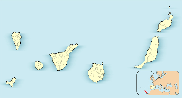 Canary Islands | |
| Location |
Lobos Island Fuerteventura Canary Islands Spain |
|---|---|
| Coordinates | 28°45′54″N 13°48′54″W / 28.764957°N 13.814879°WCoordinates: 28°45′54″N 13°48′54″W / 28.764957°N 13.814879°W |
| Year first constructed | 1865 |
| Construction | stone tower |
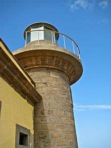
| Tower shape | cylindrical tower with balcony and lantern |
| Markings / pattern | unpainted tower, grey lantern |
| Height | 6 metres (20 ft) |
| Focal height | 29 metres (95 ft) |
| Light source | solar power |
| Range | 14 nautical miles (26 km; 16 mi) |
| Characteristic | Fl (2) W 15s. |
| Admiralty number | D2786 |
| NGA number | 24044 |
| ARLHS number | CAI-005 |
| Spain number | ES-12140 |
| Managing agent | Parque Natural Islote de Lobos[1] |
The Punta Martiño Lighthouse (Spanish: Faro de Punta Martiño) is an active lighthouse on the Canary island of Lobos, near Fuerteventura in the municipality of La Oliva.[2][3]
The lighthouse is situated on a hill at the north-eastern end of the island, and along with the other lights at Pechiguera and Tostón, marks the La Bocayna strait that separates Lanzarote from Fuerteventura.[2][4]
History
The lighthouse was opened in 1865, making it one of the oldest in the Canaries. Built in a similar style to other Canarian 19th century lights, it consists of a painted single storey house, with dark volcanic rock used for the masonry detailing. A six metre high, masonry tower is attached to the seaward side of the house.[2]
The sixth order light was originally powered by olive oil, and gave a steady red light that had a range of 9 miles. In 1883, the oil powered lamp was replaced by one that ran on paraffin, and then in 1923 this was superseded by an acetylene lamp, that provided a longer range, and flashed twice every five seconds. An automatic sun valve was also added, to save the keeper having to light and extinguish the lamp, each day at dusk and dawn. A system of solar panels and batteries now provide the power for a 150 Watt electric halogen lamp, which has a reach of 14 nautical miles. When the lighthouse was automated in the 1960s the keeper and his family were the last to leave the island, which now has no permanent residents.[5][6][7]
The area around the lighthouse can be reached by following the marked 3.5 km footpath from the ferry landing; although the site is accessible, the tower and buildings are closed.[2]
Map
_-_OSM_Mapnik.svg.png)
See also
References
- ↑ Punta Martiño The Lighthouse Directory. University of North Carolina at Chapel Hill. Retrieved March 29, 2016
- 1 2 3 4 Rowlett, Russ. "Lighthouses of Spain: Canary Islands". The Lighthouse Directory. University of North Carolina at Chapel Hill. Retrieved 15 December 2014.
- ↑ "12140 Faro Punta Martino". Aids to Navigation. Puertos del Estado. Retrieved 15 December 2014.
- ↑ "Museum of Traditional Fishing". Museums. artesaniaymuseosdefuerteventura.org. Retrieved 15 December 2014.
- ↑ "Las Palmas - Faro Punta Martino". History of the Lighthouses (in Spanish). Puertos del Estado. Retrieved 15 December 2014.
- ↑ "Faro de Punta Martino". Maritime Signals (in Spanish). Puertos de las Palmas. Retrieved 15 December 2014.
- ↑ Dorling Kindersley (3 May 2010). DK Eyewitness Travel Guide: Canary Islands. Dorling Kindersley Limited. p. 71. ISBN 978-1-4053-5200-0.
External links
| Wikimedia Commons has media related to Faro de Martiño. |
| Las Palmas |
|  | |||||||||||||
|---|---|---|---|---|---|---|---|---|---|---|---|---|---|---|---|
| Santa Cruz |
| ||||||||||||||