Puntarenas (canton)
| Puntarenas | |
|---|---|
|
Cantón | |
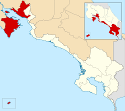 Location of Puntarenas Canton in Puntarenas Province | |
| Country | Costa Rica |
| Province | Puntarenas |
| Area | |
| • Total | 1,842.33 km2 (711.33 sq mi) |
| Population (June 2013) | |
| • Total | 126,515 |
| • Density | 69/km2 (180/sq mi) |
Puntarenas is the first canton in the province of Puntarenas in Costa Rica. The canton covers an area of 1,842.33 km²,[1] and has a population of 126,515.[2] The provincial capital is the city of Puntarenas.
Geography
The canton includes areas on both sides of the Gulf of Nicoya. From the western coastline, the canton ranges eastward into the Cordillera de Tilarán to include the Monteverde region. The southern portion of the Nicoya Peninsula is also in the canton, including the popular tourist areas of Tambor, Montezuma and Malpais.
The canton of Puntarenas is subdivided into 16 distritos (Spanish: "districts"):
- Puntarenas
- Pitahaya
- Chomes
- Lepanto
- Paquera
- Manzanillo
- Guacimal
- Barranca
- Monteverde
- Isla de Coco
- Cóbano
- Chacarita
- Isla Chira
- Acapulco
- El Roble
- Arancibia
History
Puntarenas was first mentioned as a canton in a decree dated 7 December 1848.
References
- ↑ Instituto Geográfico Nacional (IGN), 2001.
- ↑ Estadísticas Vitales 2013 - INEC
Coordinates: 9°58′N 84°50′W / 9.967°N 84.833°W
This article is issued from Wikipedia - version of the 11/27/2015. The text is available under the Creative Commons Attribution/Share Alike but additional terms may apply for the media files.