Puster Valley
| Puster Valley | |
|---|---|
| District | |
| Comunità comprensoriale Val Pusteria Bezirksgemeinschaft Pustertal | |
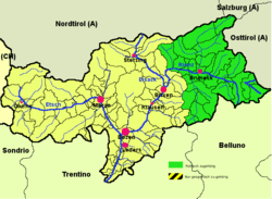 Puster Valley (highlighted in green) within South Tyrol | |
| Country |
|
| Autonomous region |
|
| Autonomous province |
|
| Established | 1969 |
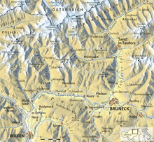
| Administrative seat | Bruneck (Brunico) |
| Area | |
| • Total | 2,072 km2 (800 sq mi) |
| Population (2005) | |
| • Total | 76,149 |
| • Density | 37/km2 (95/sq mi) |
| Website |
www |
The Puster Valley[1][2] (Italian: Val Pusteria [ˈval pusteˈriːa]; German: Pustertal, Ladin: Val de Puster) is a valley in the Alps that runs in an east-west direction between Lienz in East Tyrol, Austria and Mühlbach near Brixen in South Tyrol, Italy. The municipalities of the Puster Valley constitute the Puster Valley district.
Puster Valley

The Puster Valley is located in the western part of the Periadriatic Seam, which separates the Southern Limestone Alps from the Central Eastern Alps, as well as most of the limestone Alps from the central gneiss and slate peaks of the range's central section. East of Sillian, the Puster Valley leaves the Peradriatic Line (which moves into the Gail valley) and turns to the northeast towards Lienz.
Half of the valley drains to the west to the Adriatic via the Adige river; the other half drains to the east to the Black Sea via the Danube. The watershed lies in the shallow valley floor called Toblacher Feld (Conca di Dobbiaco). The Rienz river flows westwards through the Puster Valley and the Drau river flows eastwards into East Tyrol. The eastern part of the valley on the upper Drava is called Upper Puster Valley.
The towns in the Puster Valley are located between 750 and 1,180 meters above sea level. The most important of these towns in the western valley are Toblach, Welsberg-Taisten, Olang, and Bruneck; the most important in the eastern valley are Innichen, Sexten, and Sillian.
The largest tributaries of the Rienz river form the Antholzer Bach, the Ahr, the Pragser Bach, the Gsieser Bach, the Gran Ega, the Pfunderer Bach, and the Lüsenbach. The Puster Valley's largest side valley is the Tauferer Ahrntal. The Drau's largest eastern tributaries are the Sextner Bach and the Villgraten-Bach.
Puster Valley District
The Puster Valley District (Italian: Comprensorio della Val Pusteria; German: Bezirksgemeinschaft Pustertal) was founded in 1969 with the merger of 26 municipalities. Its combined area is 2,071 km² and its population is over 73,000. Its main town is Bruneck. According to the 2001 census, 80.96% of the population of the valley speak German, 13.40% Ladin, and 5.64% Italian as their native language.[3]
The following municipalities are part of the Puster Valley District:
Gallery
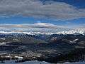 Ahrntal and Bruneck
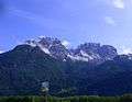 Lienzer Dolomite range in East Tyrol in the Upper Puster Valley
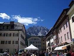 Innichen
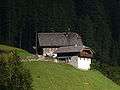 Farmhouse in the Antholz Mittertal valley
 Heiligkreuzkofel in the Abteital valley
 The Puster Valley near Bruneck
References
- ↑ Pignatti, Erika, & Sandro Pignatti. 2014. Plant Life of the Dolomites: Vegetation Structure and Ecology. Heidelberg: Springer, p. 612.
- ↑ Russ, Charles. 1990. The Dialects of Modern German: A Linguistic Survey. London: Routledge, p. 480.
- ↑ Bevölkerung und soziales Leben, Statistisches Jahrbuch 2006, p. 120, tab. 3.19
External links
 Media related to Puster Valley at Wikimedia Commons
- Puster Valley District (German) (Italian)
| |||
Coordinates: 46°44′N 12°13′E / 46.733°N 12.217°E