Puzzletown, Pennsylvania
Puzzletown (40°22′37″N 78°29′24″W / 40.37694°N 78.49000°W) is an unincorporated community in Blair County, Pennsylvania.[1]
Geography
It is found at the bottom of a valley which leads up to Blue Knob, the second-highest mountain in the state and part of the Allegheny Front, the eastern edge of the Appalachian Plateau. It is a rural area with a population of three to five hundred at its most liberal definition and less than one hundred at its most restrictive.
Puzzletown is considered by most to be the Puzzletown Road, a road leading to the southwest from Newry, Pennsylvania, and all of the short side streets and housing developments on it; others extend this for several miles after the road's name becomes Knob Run Road and others limit it to only the intersection of Puzzletown Road and Poplar Run Road and the few nearby side streets.
History
Formerly called Poplar Run, Puzzletown was founded in about 1840.[2]
References
- ↑ U.S. Geological Survey Geographic Names Information System: Puzzletown, Pennsylvania
- ↑ Africa, J. Simpson (1883). History of Huntingdon and Blair Counties, Pennsylvania. Louis H. Everts. p. 1.
Municipalities and communities of Blair County, Pennsylvania, United States | ||
|---|---|---|
| City | 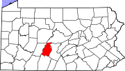 | |
| Boroughs | ||
| Townships | ||
| CDPs | ||
| Unincorporated communities | ||
| Footnotes | ‡This populated place also has portions in an adjacent county or counties | |