Pyana River
| Pyana | |
|---|---|
 | |
 | |
| Country | Russia |
| Basin | |
| Main source |
Volga Upland 220 m (720 ft) |
| River mouth |
Sura River 62 m (203 ft) |
| Basin size | 8,060 km2 (3,110 sq mi) |
| Physical characteristics | |
| Length | 436 km (271 mi) |
| Discharge |
|

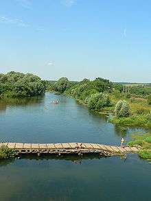
Pyana (Russian: Пья́на) is a river in Nizhny Novgorod Oblast and the Republic of Mordovia, Russia. It is a tributary of the Sura River.
History and etymology
Pyana translates from Russian into drunken. The original name of the river was likely Piana,[1] and, like many other old Russian geographical names, might be of Finnish origin (pien meaning small).[2] The most likely reason for the transformation of Piana to Pyana was the Battle on Pyana River.[3] The battle was fought on 2 August 1377 between the Blue Horde Khan Arapsha (Arab-Shah Muzaffar) and joint Russian troops under Knyaz Ivan Dmitriyevich. Awaiting the battle, the Russian Army lost discipline with drunkenness being a norm. They were unexpectedly attacked from all sides and crushed by the Mongols, forcing retreat to and across the Pyana. Many soldiers, and the Knyaz himself, drowned while crossing it.[1][4] This explanation is further supported by the original text of the chronicles of the battle, where the writer first calls the river Piana, then notes[5] the ironical similarity of the words piana and pyana (in a sense of drunkenness) and further uses Pyana as the river name.[1]
Geography and hydrology
The river is 436 km long; it freezes around November and thaws in April. The average discharge 65 km from its mouth is 25 m³/s and it can vary between 10 and 1,500 m³/s. River banks contain numerous karst caves.[6] Pyana is remarkable by its shape: it runs to the north-west and then turns 180° south-east making a nearly closed loop (see map) before turning north and merging with the Sura.[7]
Human activities
The towns of Perevoz and Sergach are located on the Pyana. The river is navigable in its lower reaches.[6] On the river banks there is Ichalkovsky Natural Reserve of 936 ha area which is protected by the state since 1963.[8] There is a hydroelectric station near the village of Ichalkovo with the annual production of 600 MW. Its construction was started after World War II, but completed only in the 1990s.[9]
References
- 1 2 3 D. S. Likhachev et al., eds. (1999). Библиотека литературы Древней Руси. 6, середина XV века. St. Petersburg: Nauka; Russian Academy of Sciences.
- ↑ V. Malkin (1989). "Из истории слов. Почему реку назвали Гусем? (History of names. Why river was named after a goose)". Nauka i Zhizn. 9: 112.
- ↑ Pokhlebkin, William; Pokhlebkin, Vilʹi︠a︡m Vasilʹevich. A history of vodka (1992 ed.). Verso. p. 67. ISBN 0-86091-359-7. Google Books
- ↑ Solovyov, Sergey (1851–1879). "7". A History of Russia, vol. 3 (1851–1879 ed.).
- ↑ "Поистиннѣ — за Пьяною пьяни!"
- 1 2 Пьяна, Great Soviet Encyclopedia (in Russian)
- ↑ V. A. Mezentsev (1988). Энциклопедия чудес. Vol. 1. Обычное в необычном (Encyclopedia of wonders. Usual within unusual) (in Russian). Мoscow: Znanie.
- ↑ Пещеры и провалы Ичалковского бора, 2 May 2008 (in Russian)
- ↑ Каникулы для ГЭС, Nizhegorodskie News, 3 April 2007 (in Russian)
| Wikimedia Commons has media related to Pyana River. |
Coordinates: 55°23′N 45°33′E / 55.39°N 45.55°E