Sergach
| Sergach (English) Сергач (Russian) | |
|---|---|
| - Town[1] - | |
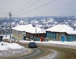 Sovetskaya Street in Sergach | |
.svg.png) Location of Nizhny Novgorod Oblast in Russia | |
.svg.png) Sergach | |
|
| |
_(1781).png) | |
|
| |
| Administrative status (as of February 2014) | |
| Country | Russia |
| Federal subject | Nizhny Novgorod Oblast[1] |
| Administrative district | Sergachsky District[1] |
| Town of district significance | Sergach[1] |
| Administrative center of | Sergachsky District,[1] town of district significance of Sergach[1] |
| Municipal status (as of August 2009) | |
| Municipal district | Sergachsky Municipal District[2] |
| Urban settlement | Sergach Urban Settlement[2] |
| Administrative center of | Sergachsky Municipal District,[2] Sergach Urban Settlement[2] |
| Statistics | |
| Population (2010 Census) | 21,386 inhabitants[3] |
| Time zone | MSK (UTC+03:00)[4] |
| First mentioned | 1649 |
| Town status since | 1779 |
| Postal code(s)[5] | 607500, 607510, 607511, 607513, 607514 |
| Sergach on Wikimedia Commons | |
Sergach (Russian: Серга́ч) is a town and the administrative center of Sergachsky District in Nizhny Novgorod Oblast, Russia, located on the Pyana River (Sura's tributary), 150 kilometers (93 mi) southeast of Nizhny Novgorod, the administrative center of the oblast. Population: 21,386 (2010 Census);[3] 22,887 (2002 Census);[6] 25,231 (1989 Census).[7]
History
The village of Sergach was first mentioned in 1649. It was granted town status in 1779.
Administrative and municipal status
Within the framework of administrative divisions, Sergach serves as the administrative center of Sergachsky District.[1] As an administrative division, it is, together with two rural localities, incorporated within Sergachsky District as the town of district significance of Sergach.[1] As a municipal division, the town of district significance of Sergach is incorporated within Sergachsky Municipal District as Sergach Urban Settlement.[2]
Transportation
The town is located on one of the Russia's high-speed railways connecting Moscow with Kazan and has its own railway station.
References
Notes
- 1 2 3 4 5 6 7 8 Order #3-od
- 1 2 3 4 5 Law #157-Z
- 1 2 Russian Federal State Statistics Service (2011). "Всероссийская перепись населения 2010 года. Том 1" [2010 All-Russian Population Census, vol. 1]. Всероссийская перепись населения 2010 года (2010 All-Russia Population Census) (in Russian). Federal State Statistics Service. Retrieved June 29, 2012.
- ↑ Правительство Российской Федерации. Федеральный закон №107-ФЗ от 3 июня 2011 г. «Об исчислении времени», в ред. Федерального закона №271-ФЗ от 03 июля 2016 г. «О внесении изменений в Федеральный закон "Об исчислении времени"». Вступил в силу по истечении шестидесяти дней после дня официального опубликования (6 августа 2011 г.). Опубликован: "Российская газета", №120, 6 июня 2011 г. (Government of the Russian Federation. Federal Law #107-FZ of June 31, 2011 On Calculating Time, as amended by the Federal Law #271-FZ of July 03, 2016 On Amending Federal Law "On Calculating Time". Effective as of after sixty days following the day of the official publication.).
- ↑ Почта России. Информационно-вычислительный центр ОАСУ РПО. (Russian Post). Поиск объектов почтовой связи (Postal Objects Search) (Russian)
- ↑ Russian Federal State Statistics Service (May 21, 2004). "Численность населения России, субъектов Российской Федерации в составе федеральных округов, районов, городских поселений, сельских населённых пунктов – районных центров и сельских населённых пунктов с населением 3 тысячи и более человек" [Population of Russia, Its Federal Districts, Federal Subjects, Districts, Urban Localities, Rural Localities—Administrative Centers, and Rural Localities with Population of Over 3,000] (XLS). Всероссийская перепись населения 2002 года [All-Russia Population Census of 2002] (in Russian). Retrieved August 9, 2014.
- ↑ Demoscope Weekly (1989). "Всесоюзная перепись населения 1989 г. Численность наличного населения союзных и автономных республик, автономных областей и округов, краёв, областей, районов, городских поселений и сёл-райцентров" [All Union Population Census of 1989: Present Population of Union and Autonomous Republics, Autonomous Oblasts and Okrugs, Krais, Oblasts, Districts, Urban Settlements, and Villages Serving as District Administrative Centers]. Всесоюзная перепись населения 1989 года [All-Union Population Census of 1989] (in Russian). Институт демографии Национального исследовательского университета: Высшая школа экономики [Institute of Demography at the National Research University: Higher School of Economics]. Retrieved August 9, 2014.
Sources
- Государственно-правовой департамент Нижегородской области. Приказ №3-од от 23 января 2015 г. «Об утверждении реестра административно-территориальных образований, городских и сельских населённых пунктов Нижегородской области», в ред. Приказа №32-од от 22 мая 2015 г «О внесении изменений в Реестр административно-территориальных образований, городских и сельских населённых пунктов Нижегородской области». Опубликован: Эталонный банк данных правовой информации Губернатора и Правительства Нижегородской области. (State Legal Department of Nizhny Novgorod Oblast. Order #3-od of January 23, 2015 On the Adoption of the Registry of the Administrative-Territorial Formations, Urban and Rural Localities of Nizhny Novgorod Oblast, as amended by the Order #32-od of May 22, 2015 On Amending the Registry of the Administrative-Territorial Formations, Urban and Rural Localities of Nizhny Novgorod Oblast. ).
- Законодательное Собрание Нижегородской области. Закон №157-З от 24 октября 2005 г. «Об утверждении границ, состава территории Сергачского муниципального района, границ и состава территорий муниципальных образований, входящих в состав Сергачского муниципального района», в ред. Закона №132-З от 28 августа 2009 г. «О преобразовании муниципальных образований — сельских поселений Акузовский сельсовет, Андинский сельсовет, Андреевский сельсовет, Ачкинский сельсовет, Богородский сельсовет, Воскресенский сельсовет, Лопатинский сельсовет, Мокро-Майданский сельсовет, Пицинский сельсовет, Сосновский сельсовет, Толбинский сельсовет, Яновский сельсовет Сергачского муниципального района Нижегородской области и о внесении изменений в отдельные Законы Нижегородской области». Вступил в силу по истечении десяти дней со дня официального опубликования. Опубликован: "Правовая среда" №88–90(654–656) (приложение к газете "Нижегородские новости" №214(3386)), 16 ноября 2005 г. (Legislative Assembly of Nizhny Novgorod Oblast. Law #157-Z of October 24, 2005 On Establishing the Borders and the Composition of Sergachsky Municipal District, the Borders and the Composition of the Municipal Formations Within Sergachsky Municipal District, as amended by the Law #132-Z of August 28, 2009 On the Transformation of the Municipal Formations—Rural Settlements of Akuzovsky Selsoviet, Andinsky Selsoviet, Andreyevsky Selsoviet, Achkinsky Selsoviet, Bogorodsky Selsoviet, Voskresensky Selsoviet, Lopatinsky Selsoviet, Mokro-Maydansky Selsoviet, Pitsinsky Selsoviet, Sosnovsky Selsoviet, Tolbinsky Selsoviet, Yanovsky Selsoviet of Sergachsky Municipal District of Nizhny Novgorod Oblast and on Amending Various Laws of Nizhny Novgorod Oblast. Effective as of the day after ten days from the day of the official publication have passed.).