Pyrmont Bridge
| Pyrmont Bridge | |
|---|---|
|
Pyrmont Bridge in 2014. | |
| Carries | Pedestrian and bicycle traffic |
| Crosses | Cockle Bay |
| Locale | Darling Harbour, Sydney, New South Wales, Australia |
| Owner | Sydney Harbour Foreshore Authority |
| Maintained by | Sydney Harbour Foreshore Authority |
| Heritage status |
Heritage Council of NSW; Engineers Australia (1992) National Engineering Landmark |
| Preceded by | Pyrmont Bridge (1858–1902) |
| Followed by | Western Distributor (1981–present) |
| Characteristics | |
| Design | Swing bridge |
| Material |
Ironbark timber; Steel central spans |
| Total length | 369 metres (1,211 ft) |
| Number of spans | 14 |
| Clearance above | 6.5 metres (21 ft) |
| History | |
| Engineering design by | Percy Allan |
| Construction begin | 6 December 1899 |
| Construction cost | £112,500 |
| Opened | 28 June 1902 |
| Statistics | |
| Daily traffic | ~14,000 pedestrians |
| References | |
| [1][2][3] | |
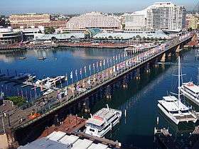
The Pyrmont Bridge, a swing bridge across Cockle Bay, is located in Darling Harbour, part of Port Jackson, west of the central business district in Sydney, New South Wales, Australia. Opened in 1902, the bridge initially carried motor vehicle traffic via the Pyrmont Bridge Road between the central business district and Pyrmont. Since 1981 the bridge has carried pedestrian and bicycle traffic only, as motor vehicles were diverted to adjacent freeway overpasses.
History
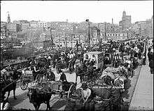
The first Pyrmont Bridge was opened on 17 March 1858,[4] and was a wooden pile bridge with an iron centre 'swing panel' to allow ships to pass. In the first two weeks 20,000 pedestrians paid the one penny toll. It was also crossed by "932 carts and drays, 43 gigs, 17 carriages and 125 horse and rider." When the government bought the bridge for £52,500 from the Pyrmont Bridge Company in 1884, they abolished the toll. The wooden Pyrmont Bridge vanished with the construction in 1902 of a new steel bridge which took 33 months to build and was completed in time to accommodate Sydney's first cars.[5]
Description
The foundation stone for the new bridge was laid on 6 December 1899 by E. W. O'Sullivan and the bridge was opened for traffic on 28 June 1902 by the Governor of New South Wales, Harry Rawson.[6] The bridge was designed under the engineering supervision of Percy Allan. The bridge had one of the largest swing spans in the world at the time of its construction and it was one of the first to be powered by electricity. Allen also designed the similar Glebe Island Swing Bridge, completed in 1903.
The Pyrmont Bridge is 369 metres (1,211 ft) long and cost £112,500 to build. The bridge is made up of 14 spans with Australian ironbark timber used on 12 spans, while the two central spans, which swing, are constructed from steel. The swingspan weighs 1,000 tonnes (1,100 short tons) and is supported on a base made from concrete and Hawkesbury Sandstone. The base is filled with mass concrete and weighs 6,800 tonnes (7,500 short tons). The swingspan is 13 metres (43 ft) in diameter and 19 metres (62 ft) deep. The water is 6.5 metres (21 ft) deep and the base extends a further 10 metres (33 ft) below the sea floor.[3]
Pyrmont Bridge takes approximately 60 seconds to open completely to 83 degrees. It has to be opened for vessels more than 7 metres (23 ft) high. Vessels/barges up to 21.5 metres (71 ft) wide can pass through the channel once the Bridge has been opened. Pyrmont Bridge is driven by the original two 50 horsepower (37 kW) 600 V DC General Electric type 57 electric motors. Manual drum-type General Electric tramway controllers are used to drive the motors for the swingspan and gates. Power to operate the bridge was originally drawn from the Ultimo Power House (now the Powerhouse Museum). As a young engineer, J.J.C. Bradfield helped design the sandstone abutment walls at each end of Pyrmont Bridge.[3]
In 1981 the Wran government ordered the bridge to be demolished, but later revoked this decision.[5] The bridge was closed to vehicular traffic on 7 August 1981,[3] the traffic having been diverted over the Western Distributor freeway structures built further south of Cockle Bay, and it was then re-opened as a pedestrian bridge as part of the re-development of Darling Harbour as a recreational pedestrian precinct. The swing bridge remains in operation, and opens to a schedule managed by the Sydney Harbour Foreshore Authority.[7]
In 1992 Engineers Australia recognised the bridge as a National Engineering Landmark.[2]
Modifications
Between 1988 and 2013, the bridge carried the elevated Sydney Monorail, which travelled between Darling Harbour and the Sydney central business district. The monorail track rested on a pivot that allowed the track to remain stationary while the bridge swung underneath. The pivot allowed the monorail to continue to cross the bridge even when the bridge was opened. Upon the closure of the Monorail in June 2013 the hydraulic lifting rams and support infrastructure were removed, and the control cab was to be relocated to its original position in the middle of the bridge.[8]
Gallery
 The point at which the bridge turns
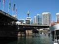 Pyrmont Bridge mid-swing.
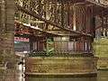
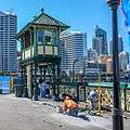 The swinging operation is controlled from a tower in the centre of the bridge. Control Cabin relocation 2013
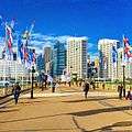 Looking at CBD
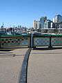 The arc-shaped split between bridge sections is shown here.
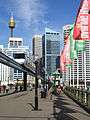 Pyrmont Bridge (with monorail)
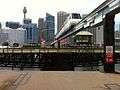 Monorail travelling over Pyrmont Bridge while the bridge is open.
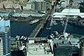 The bridge as viewed from the Sydney Tower.
See also
References
- ↑ "Pyrmont Bridge". Heritage Council of New South Wales. Government of New South Wales. 2008. Retrieved 14 January 2015.
- 1 2 "Pyrmont Bridge". Engineering Heritage National Landmarks. Engineers Australia. Retrieved 30 December 2013.
- 1 2 3 4 "Pyrmont Bridge: A symbol of Australia's industrial history". Sydney Harbour Foreshore Authority. Government of New South Wales. Retrieved 14 January 2015.
- ↑ "Notes of the Week". The Sydney Morning Herald. 22 March 1858. Retrieved 10 September 2010.
- 1 2 "Pyrmont Bridge". Sydney Architecture. Retrieved 14 January 2015.
- ↑ "The New Pyrmont Bridge". Sydney Morning Herald. National Library of Australia. 30 June 1902. Retrieved 10 September 2010.
- ↑ "Pyrmont Bridge opening times". Sydney Harbour Foreshore Authority. Government of New South Wales. Retrieved 14 January 2015.
- ↑ "PYRMONT BRIDGE Monorail Removal Project" (PDF). Transport for NSW.
| Wikimedia Commons has media related to Pyrmont Bridge, Sydney. |
Further reading
- "Pyrmont Electric Swing Bridge". The Engineer. London. 123: 75–8, 84, 103–6, 110, 124–6, 132, 150–3. 1917.
External links
- Kass, Terry (February 2006). "RTA Thematic History: A component of the RTA Heritage and Conservation Register" (PDF). NSW Roads & Maritime Services (PDF) (2nd ed.). Government of New South Wales. Retrieved 12 January 2015.
- Pyrmont Bridge at Structurae
- Engineers Australia
- Christa Ludlow (2010). "Pyrmont Bridge 1902". Dictionary of Sydney. Retrieved 8 October 2015. [CC-By-SA]
Coordinates: 33°52′14″S 151°12′02″E / 33.870575°S 151.200667°E