Captain Cook Bridge, New South Wales
| Captain Cook Bridge, Sydney | |
|---|---|
|
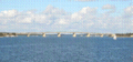
Captain Cook Bridge, Sydney, view from Sans Souci | |
| Coordinates | 34°00′29″S 151°07′39″E / 34.00794444°S 151.1276083°ECoordinates: 34°00′29″S 151°07′39″E / 34.00794444°S 151.1276083°E |
| Carries | Motor vehicles, pedestrians and bicycles |
| Crosses | Georges River |
| Locale | Southern Sydney, New South Wales, Australia |
| Owner | Roads and Maritime Services |
| Characteristics | |
| Material | Concrete girder |
| Total length | 506 metres (1,660 ft) |
| Width | 27.5 metres (90 ft) |
| Number of spans | 7 |
| History | |
| Constructed by | John Holland Group |
| Construction begin | 1962 |
| Construction end | 1965 |
| Construction cost | A$3 million |
| Opened | 29 May 1965 |
| References | |
| [1] | |

The Captain Cook Bridge is a six-lane precast prestressed concrete girder bridge for motor vehicles, pedestrians and bicycles, that crosses the Georges River in southern Sydney, in the state of New South Wales, Australia. The bridge crosses near the river mouth as it empties into Botany Bay; and links the St George and Sutherland areas of Sydney.
Location and features
The Captain Cook Bridge consists of seven spans totalling 475 metres (1,558 ft) in length, with a 506-metre (1,660 ft) long deck that is 27.5 metres (90 ft) wide with initially eight traffic lanes and two footways. The roadway now carries three lanes of traffic in either direction, plus shared bicycle and pedestrian paths, segregated from the roadway on both the eastern and western sides of the bridge. Its foundations go up to 67 metres (220 ft) below water level to its sandstone base. The bridge was opened on 29 May 1965[1] and links Rocky Point Road at Sans Souci in the St George area to Taren Point Road at Taren Point in the Sutherland Shire. Loop walkways run under the bridge at both sides and provide access along the foreshore.
The bridge is the easternmost of the three major crossings over the Georges River. The other two are Tom Uglys Bridge, which opened in 1929 and Alfords Point Bridge, which opened in 1973.
The Captain Cook Bridge is the only section of the planned F6 Freeway that has been built inside the Sydney metropolitan area; with the other sections being between Waterfall and Bulli Tops and further south between Gwynneville to Yallah.[1] The speed limit across the bridge and associated road sections is 70 kilometres per hour (43 mph).[2]
The bridge was designed to have the capacity to carry 30,000 vehicles on a weekday, but in 2015 the bridge was estimated to be carrying 30,600 vehicles per weekday.[3]
History
A ferry service ran between Sans Souci and Taren Point from 1911. From April 1916 a vehicular punt ran between the two points,[4] and continued to do so even after the opening of the Tom Uglys Bridge in 1929.
The Captain Cook Bridge is named in honour of Captain James Cook, a British explorer, navigator, cartographer, and captain in the Royal Navy, who landed at nearby Kurnell on 29 April 1770, during his first voyage of discovery aboard the Endeavour.[5]
A big part of commissioning the Captain Cook Bridge was the fact that the nearby Tom Ugly's Bridge was carrying more traffic than any three lanes of the Sydney Harbour Bridge before 1962, and the Taren Point punt was at full capacity carrying 1000 cars daily.[3]
Gallery
-
Captain Cook Bridge, as viewed from Blakehurst.
-
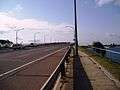
Captain Cook Bridge, as viewed from Taren Point Road.
-
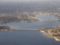
Captain Cook Bridge in the foreground, and Tom Uglys Bridge behind.
-

Captain Cook Bridge taken from Taren Point End at night.
See also
References
- 1 2 3 "1965 – Captain Cook Bridge". Sydney for everyone. Archived from the original on 21 December 2013. Retrieved 14 June 2014.
- ↑ Trembath, Murray (8 November 2013). "Speed limit on approach to Captain Cook Bridge won't change, but warning signs reviewed". St George and Sutherland Shire Leader. Retrieved 14 June 2014.
- 1 2 Trembath, Murray (5 June 2015). "Captain Cook Bridge anniversary a reminder of unfinished work". The Leader. Retrieved 13 June 2015.
- ↑ "George's River Ferry". The Sydney Morning Herald. 4 March 1916. Retrieved 13 September 2010.
- ↑ "Captain Cook Bridge (1965), southern approach". Heritage and conservation register. Roads and Traffic Authority, New South Wales. 18 November 2005. Retrieved 13 September 2010.
External links
- "Boating Safety Plan (Botany Bay, Georges River, Woronora River, Cooks River)" (PDF). Roads and Maritime Services (PDF). Office of Boating Safety and Maritime Affairs, Policy and Regulation Division, Transport for New South Wales. November 2012.