Qal'at Ja'bar
| Qal'at Ja'bar | |
|---|---|
|
قلعة جعبر Caber Kalesi Qal'at Dawsar (ancient name) | |
| Ar-Raqqah Governorate, Syria | |
|
Qal'at Ja'bar from the north, surrounded by the waters of Lake Assad | |
|
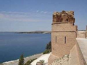
One of the bastions of Qal'at Ja'bar | |
 Qal'at Ja'bar | |
| Coordinates | 35°53′51″N 38°28′51″E / 35.8975°N 38.480833°E |
| Type | Castle |
| Site information | |
| Open to the public | Yes |
| Condition | Partially restored ruin |
| Site history | |
| Built | 1168 |
| Built by | Nur ad-Din Zangi |
| Materials | Stone and brick |
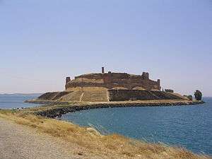
Qal'at Ja'bar (Arabic: قلعة جعبر, Turkish: Caber Kalesi) is a castle on the left bank of Lake Assad in Ar-Raqqah Governorate, Syria. Its site, formerly a prominent hill-top overlooking the Euphrates Valley, is now an island in Lake Assad that can only be reached by an artificial causeway. Although the hilltop on which the castle sits was possibly already fortified in the 7th century, the current structures are primarily the work of Nur ad-Din Zangi, who rebuilt the castle from 1168 onwards. Since 1965, several excavations have been carried out in and around the castle, as well as restoration works of the walls and towers. The castle was a Turkish exclave between 1921 and 1973.
History
Before the castle
It is not exactly known when the hilltop of Qal'at Ja'bar was first fortified. The site was already known as "Dawsar" in pre-Islamic times and was located along a route connecting ar-Raqqah with the west.[1][2]
11th century and later
The castle may have been built by the Banu Numayr tribe in the 11th century. Historical sources mention that the castle was given by Malik Shah I to descendants of the Uqaylid dynasty in 1086. They held the castle almost continuously until the late 12th century, except for a brief occupation by Crusaders in 1102. In 1146, Zengi besieged the castle, but he was murdered there by one of his own slaves. In 1168, Qal'at Ja'bar passed into the hands of Zengi's son Nur ad-Din, who undertook major construction works at the castle. Most of what can be seen today dates to this period. The castle was heavily damaged during the Mongol invasions of Syria. Restoration works were carried out in the 14th century.[1][3][4]
Tomb of Suleyman Shah
Suleyman Shah, the grandfather of Osman I (progenitor of the Ottoman Empire), reputedly drowned in the Euphrates near Qal'at Ja'bar, and was buried near the castle. However, it is probable that this story resulted from a confusion between Suleyman Shah, and Sulayman bin Kutalmish, the founder of the Seljuk Sultanate of Rûm. It is however not certain whether the actual tomb, known as Mezār-i Türk, related to either of these two rulers.[1] The Ottoman sultan Hamid II had the tomb reconstructed. By article 9 of the Treaty of Ankara of 1921, the area was accepted as Turkish territory and Turkish soldiers were allowed to guard the tomb after Syria's establishment as a French mandate and eventual independence.[5] In 1973, in response to the rising water level of the newly created Lake Assad, the reputed tomb of Suleyman Shah and the associated exclave were moved to a new location north of Qal'at Ja'bar and Qal'at Ja'bar itself became Syrian territory.[4]
Architecture
Qal'at Ja'bar measures 370 by 170 metres (1,210 ft × 560 ft). The castle consists of a stone-built wall with 35 bastions around a rock core, and is partially surrounded by a dry moat.[6] The layout of the castle is very reminiscent of the much better preserved citadel of Aleppo. The upper parts of the castle are built from baked bricks. The entrance to the inner parts of the castle consists of a gatehouse and a winding ramp cut out of the rock. Inside the castle are the remains of a vaulted hall, as well as minaret that was probably built by Nur ad-Din, and that is the highest part of the castle. The brickwork that is currently visible is mainly the result of extensive restoration works by the Syrian Directorate-General of Antiquities and Museums (DGAM).[4][7][8]
Restoration and excavation
In 1968, construction of the Tabqa Dam commenced, as a result of which the area upstream would eventually be flooded by the dam's reservoir. In anticipation of the filling of the reservoir, excavations and restoration works were carried out at numerous sites in the region, including Qal'at Ja'bar. Although the location of Qal'at Ja'bar on a prominent hilltop ensured that it would not be flooded, the eventual lake level would turn the castle into an island. It was therefore surrounded by a protective glacis, and it was connected to the mainland by a causeway. These works were carried out between 1965 and 1974 by the Architectural Service of the DGAM, the Directorate General of the Dam and UNESCO at a cost of 4 million Syrian pounds.[6][9] The restoration focused primarily on the eastern walls and towers. In addition, parts of the western ramparts were restored, as well as the donjon Alia, which was intended to house a museum for the finds of the excavations at the castle. To facilitate the restoration, a small brickworks was established at the castle.[6] Finds from the castle are now on display in the National Museum of Aleppo and Ar-Raqqah Museum.[9][10]
References
- 1 2 3 Sourdel, D. (2010). "ḎJabar or Ḳalat ḎJabar". In Bearman, P.; Bianquis, Th.; Bosworth, C.E.; van Donzel, E.; Heinrichs, W.P. Encyclopaedia of Islam, Second Edition. Leiden: Brill Online. OCLC 624382576.
- ↑ Musil, A. (1927). The Middle Euphrates. A topographical itinerary. Oriental Explorations and Studies. 3. New York: American Geographical Society. pp. 94–95. OCLC 1458654.
- ↑ Heidemann, S. (2010). "Zangī, Abu 'l-Muzaffar 'Imād al-Dīn b. Ḳasīm al- Dawla Aḳsunḳur b. Il - Turghān". In Bearman, P.; Bianquis, Th.; Bosworth, C.E.; van Donzel, E.; Heinrichs, W.P. Encyclopaedia of Islam, Second Edition. Leiden: Brill Online. OCLC 624382576.
- 1 2 3 Burns, R. (1999). Monuments of Syria. An historical guide. London: I.B. Tauris. pp. 180–181. ISBN 1-86064-244-6.
- ↑ "Franco-Turkish agreement of Ankara" (PDF) (in French). Retrieved 19 September 2009.
- 1 2 3 Bahnassi, A. (1978). "Le sauvatage des vestiges de la zone de submersion du barrage de Tabqa sur l'Euphrate" (PDF). Monumentum (in French). ICOMOS. 17: 57–70. ISSN 0027-0776.
- ↑ Hillenbrand, C. (1999). The Crusades: Islamic perspectives. Edinburgh: Edinburgh University Press. pp. 495–496. ISBN 1-57958-210-9.
- ↑ Bell, G.L. (1924). Amurath to Amurath (2nd ed.). London: MacMillan. pp. 48–51. OCLC 481634750.
- 1 2 Bounni, Adnan; Lundquist, J. M. (1977). "Campaign and exhibition from the Euphrates in Syria". The Annual of the American Schools of Oriental Research. 44: 1–7. ISSN 0066-0035. JSTOR 3768538.
- ↑ Zaqzuq, A.R. (1985). "Fouilles de la citadelle de Ja'bar". Syria (in French). 62 (1/2): 140–141. ISSN 0039-7946. JSTOR 4198474.
Further reading
- Tonghini, Cristina (1998). Qal'at Ja'bar pottery: a study of a Syrian fortified site of the late 11th-14th centuries. British Academy Monographs in Archaeology. 11. Oxford: Oxford University Press. ISBN 0-19-727010-7.
- Dussaud, René (1931). La Syrie antique et médiévale illustrée. Bibliothèque archéologique et historique. 17. Paris: P. Geuthner. OCLC 610530151.
External links
 Media related to Qal'at Ja'bar at Wikimedia Commons
Coordinates: 35°53′49″N 38°28′52″E / 35.8969°N 38.48101°E