Calderstones School
|
Current school crest | |
| Motto | "Ex Hoc Metallo Virtutem" - "Courage, Service, Honour"[1] |
|---|---|
| Type | Comprehensive secondary school |
| Acting Headteacher | Mr Lee Ratcliffe |
| Deputy Headteacher | Mrs Sharon Ellis |
| Chair of Governors | Mr David Woods |
| Location |
Harthill Road Liverpool Merseyside L18 3HS England |
| Local authority | Liverpool City Council |
| DfE number | 341/4427 |
| DfE URN | 104698 Tables |
| Staff | 150 |
| Students | approx. 1,500 |
| Gender | Co-educational |
| Ages | 11–18 |
| Colours | |
| Website | Calderstones School |
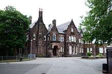
Calderstones School is an English comprehensive school located opposite Calderstones Park on Harthill Road in the Liverpool suburb of Allerton.[2]
The school was founded in 1921 as Quarry Bank High School and its first intake of 225 pupils was on 11 January 1922.[1] The first headmaster of the school was R.F. Bailey (an old Etonian). He formed the school on the principles of public school houses. Subsequently, the first year boys' house was named Bailey.[1] The current Acting Headteacher is Mr. Lee Ratcliffe.[1]
The school has several notable pupils including founding Beatles member John Lennon.
History
In 1967 Quarry Bank High Boys' school merged with neighbouring Calder High School for Girls (a girls' grammar school also on Harthill Road) and nearby Morrison School and adopted the name Quarry Bank Comprehensive School. The same year saw the abolition of the school's house system, whereby the pupils were divided between Mersey, Esmeduna, Wavertree, Sefton, Allerton, Childwall, Aigburth and Woolton Houses. In 1985, the school merged with Aigburth Vale High School, which left the school operating at four discrete locations and with 1,800 pupils; it was also then that it adopted its current name. Aigburth Vale on Lark Lane was previously a grammar school with around 600 girls. In 1989 the school divested itself of its Aigburth and Morrison facilities, retaining only the original Calder House and Quarry Bank estates. A new building to replace the old Morrison Wing site was built within the existing school site. The old Morrison Wing is now home to a Tesco superstore on Mather Avenue in Allerton. Aigburth Vale High School also no longer exists and is now home to a number of private flats.[1]
Refurbishment
In 2001 the school underwent a major refurbishment as part of the Private Finance Initiative scheme. The entire site has been overhauled, with the old Calder Wing now virtually demolished. Only Calder House is now left from the old Calder Wing and this now houses the Sixth form. A new Arts Wing has been built which houses the English, MFL, Arts and Music departments. The old Quarry Wing was divided up into two separate buildings. One is Quarry House which houses both the ICT and History departments whilst also containing the main office for the school. The main classroom core of the Quarry Wing is now known as the Science Wing and houses a very large number of science labs. The school was also awarded 'Specialist Science Status' in 2001 which allows it to provide first class science facilities for its pupils.

Nearby
Calderstones Park is just across the road from the school's premises. The parish church of All Hallows Allerton, at the bottom of Harthill Road and across from the school's playing fields, boasts an unequalled display of stained glass windows made by William Morris from Edward Burne-Jones's designs.
Notable former pupils
Quarry Bank High School
- Prof. John Ashton, Director of Public Health
- Rt. Rev. Jonathan Bailey, Bishop of Derby from 1995-2005
- Clive Barker, writer, director and producer of many highly acclaimed films (Hellraiser, Candyman), books (Weaveworld, The Hellbound Heart), comic books (Razorline, Tapping the Vein) and video games (Clive Barker's Undying, Clive Barker's Jericho)
- Brian Barwick, Chief Executive of The Football Association from 2005-08
- David Basnett, trade union leader
- Michael Batty CBE FRS FBA, Bartlett Professor of Planning at University College London
- Stephen Bayley, architecture writer and Chief Executive of the Design Museum from 1986-89
- Prof. Edmund (Ted) Bellamy, Professor of Physics at Westfield College, London from 1960-84[3]
- Jim Black, former Head of Presentation at BBC Radio 4 for fourteen years, who introduced the Radio 4 UK Theme and Sailing By[4]
- Doug Bradley, actor, who played the 'Pinhead' character in Hellraiser
- Peter Cheeseman, theatre director, pioneer of theatre-in-the-round and documentary drama
- Steve Coppell, footballer and football manager
- Les Dennis, comedian and TV personality
- Prof. Alan Deyermond, Professor of Spanish at Queen Mary and Westfield College, London from 1969-87
- Peter Goldsmith (Lord Goldsmith of Allerton), who was appointed as the Labour government's Attorney General in 2001
- John Lennon, rock musician, singer/songwriter, author and peace activist, and one of the founding members of The Beatles (Lennon named The Quarrymen after the school's first title)
- Andy Merrifield, urban theorist
- Derek Nimmo, actor
- John Power, former member of the band The La's and founding member of Cast
- Ralph Price CBE, Chairman of Honeywell UK from 1971-81[5]
- Joe Royle, footballer and football manager
- Labour cabinet ministers Peter Shore and William Rodgers, who adopted the name "Quarry Bank" as part of his baronial title
- Sir James Stirling, architect
Calder High School for Girls
- Margaret Ursula Jones, archaeologist[6]
- Judith Kelly OBE, artistic director of London's Southbank Centre
- Dr. Diana Walford CBE, haematologist and Principal of Mansfield College, Oxford since 2002
Aigburth Vale High School for Girls
- Bel Mooney (briefly), journalist
- Elisabeth Sladen, actress (Doctor Who, The Sarah Jane Adventures)
Calderstones Community Comprehensive School
- Marcus Holden, international rugby player, Cyprus Rugby National Team
- Hope Akpan, footballer, midfielder for Reading Football Club
- "Zombina" and "Doc Horror", musicians in Zombina and The Skeletones
- Geoff Rowley, skateboarder, co-owner of Flip Skateboards
Notable teachers
- Actor and scriptwriter Jimmy McGovern, of Brookside and Cracker fame, was a teacher at the school for some time
- Actor Michael J. Jackson currently works at the school as a drama teacher.
References
- 1 2 3 4 5 http://www.calderstones.co.uk/history.html
- ↑ "Location Map.".
- ↑ "Obituary: Ted Bellamy - News - The Guardian". the Guardian. Retrieved 13 October 2015.
- ↑ "Jim Black". Telegraph.co.uk. 31 May 2008. Retrieved 13 October 2015.
- ↑ "Ralph Price". Telegraph.co.uk. 13 August 2004. Retrieved 13 October 2015.
- ↑ "Margaret Jones". The Guardian. 2001-05-02. ISSN 0261-3077. Retrieved 2016-08-05.
External links
Coordinates: 53°22′57″N 2°54′03″W / 53.3825°N 2.9009°W
