Quartz Mountain (Douglas County, Oregon)
| Quartz Mountain | |
|---|---|
 Quartz Mountain Location in Oregon | |
| Highest point | |
| Elevation | 5524+ ft (1683+ m) NAVD 88[1] |
| Prominence | 800 ft (244 m) [1] |
| Coordinates | 43°09′50″N 122°40′20″W / 43.163926964°N 122.672145156°WCoordinates: 43°09′50″N 122°40′20″W / 43.163926964°N 122.672145156°W [2] |
| Geography | |
| Location | Douglas County, Oregon, U.S. |
| Parent range | Cascades |
| Topo map | USGS Quartz Mountain |
Quartz Mountain is a located 35 miles (56 km) east of Roseburg in Douglas County, Oregon, United States.[1][3] Located within the Jackson Creek subbasin, a tributary of the South Umpqua River, Quartz Mountain rises to an elevation of 5,200 feet (1,585 m) in the Umpqua National Forest. It has a large deposit of high-purity silica.[4]
The summit was the site of a Forest Service lookout tower until it was removed in 1970.[5]
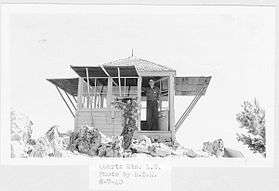
Quartz Mountain L-5 cab erected in 1933
References
- 1 2 3 "Quartz Mountain, Oregon". Peakbagger.com. Retrieved August 8, 2011.
- ↑ "Quartz Mtn Lookout House". NGS data sheet. U.S. National Geodetic Survey. Retrieved 2016-04-28.
- ↑ "Distance and Bearing between two coordinates". Geody.com. Retrieved August 8, 2011.
- ↑ "The Quartz Mountain Silica Deposit, Oregon" (PDF). Oregon Department of Geology and Mineral Industries. Nov 1960. Retrieved 14 June 2011.
- ↑ "Quartz Mountain Lookout Site". Forest Fire Lookout Association. Retrieved 2016-04-27.
External links
- Bernstein, Art (2003). Oregon byways: 75 scenic drives in the Cascades and Siskiyous, canyons and coast. Wilderness Press. p. 102. ISBN 0-89997-277-2.
- "Quartz Mountain". Geographic Names Information System. United States Geological Survey.
This article is issued from Wikipedia - version of the 11/3/2016. The text is available under the Creative Commons Attribution/Share Alike but additional terms may apply for the media files.