Quebec Route 167
| ||||
|---|---|---|---|---|
 | ||||
| Route information | ||||
| Maintained by Transports Québec | ||||
| Length: | 411.8 km[1] (255.9 mi) | |||
| Major junctions | ||||
| South end: |
| |||
|
| ||||
| North end: | Lac-Albanel | |||
| Location | ||||
| Major cities: | Saint-Félicien, Chibougamau | |||
| Highway system | ||||
| ||||

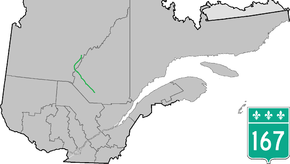
Route 167 is an isolated provincial highway in Quebec, Canada. It begins at the shore of Lac Saint-Jean in Saint-Félicien. It proceeds north-west to Chibougamau 232 km (144.2 mi) away. There are no services along this long stretch. At Chibougamau, the highway turns north-east towards Mistissini.
Maps are conflicting about the northernmost extent of this highway. The latest provincial road map[2] shows the highway ending 16 km (9.9 mi) south of Mistissini, while the pavement does continue to the town itself. According to Ministère des transports publication "Distances routières", the route continues up as far as Lac-Albanel, east of Lac Mistassini.
Municipalities along Route 167
Extension
The Quebec Department of Transportation has proposed to extend Route 167 North, in the direction of the Otish Mountains, approximately 250 km to the northeast of Albanel Lake.[3]
Construction began in February 2012. The 240 km extension to the Stornaway Renard Mine was completed in 2014.[4]
The first deliveries of liquified natural gas, by truck, with the new road where made on June 2016 to the Renard Mine.[5]
See also
References
- ↑ Ministère des transports, "Distances routières", page 74, Les Publications du Québec, 2005
- ↑ road map
- ↑ Canadian Environmental Assessment Agency news release, November 10, 2010, "Route 167 North Project in the Direction of the Otish Mountains"
- ↑ Road to Renard, Stornaway Web site
- ↑ Le Devoir, 13 June 2016
External links
- Interactive Provincial Route Map (Transports Québec) (French)
- Route 167 on Google Maps