Quebec Route 171
| ||||
|---|---|---|---|---|
 | ||||
| Route information | ||||
| Maintained by Transports Québec | ||||
| Length: | 40.0 km[1] (24.9 mi) | |||
| Major junctions | ||||
| South end: |
| |||
|
| ||||
| North end: |
| |||
| Location | ||||
| Major cities: | Lévis | |||
| Highway system | ||||
| ||||

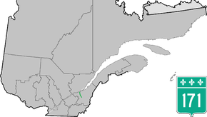
Route 171 is a north/south highway on the south shore of the St. Lawrence River in Quebec, Canada. Its southern terminus is in Scott at the junction of Route 173 and its northern terminus is in Lévis at the junction of Route 132. Route 171 follows the Chaudière River for most of its course, from the former town of Saint-Étienne-de-Lauzon up to Scott.
Since it parallels Autoroute 73, and as it is located on the western side of the Chaudiere (whereas most town centres are located on the eastern side), Route 171 is far from being a busy highway.
Municipalities along Route 171
See also
References
- ↑ Ministère des transports, "Distances routières", page 75, Les Publications du Québec, 2005
External links
- Provincial Route Map (Courtesy of the Quebec Ministry of Transportation) (French)
- Route 171 on Google Maps
This article is issued from Wikipedia - version of the 11/9/2016. The text is available under the Creative Commons Attribution/Share Alike but additional terms may apply for the media files.