Río Inabón
| Río Inabón | |
|---|---|
|
Rio Inabon in Barrio Real in Ponce, Puerto Rico | |
| Country | Puerto Rico |
| Basin | |
| Main source |
Cerro Camacho, Barrio Anón, Ponce (near Jayuya) 4,100 feet (1,200 m) |
| River mouth |
Caribbean Sea 0 feet (0 m) |
| Progression |
Anón Real Coto Laurel Capitanejo |
| River system | Río Inabón |
| Basin size | 38.18 sq mi (98.9 km2)[1] |
| Physical characteristics | |
| Length | 19.89 miles (32.01 km)[2] |
| Discharge |
|
| Features | |
| Tributaries | |
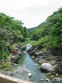
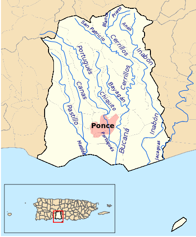
Río Inabón is a river in the municipality of Ponce, Puerto Rico. With a length of some 32.01 kilometers (19.89 mi), it is Ponce's second longest river after Río Jacaguas. It is fed by the Río Anón, Río Guayo (which itself is fed by the Chiquita Brook and the Indalecia Brook) and the Emajagua Brook.[4] It is also fed by Río Bacas and Río de las Raices.[5] This river is one of the 14 rivers in the municipality. Originating at an altitude of approximately 4,100 feet (1,200 m),[6] it forms at the highest point of any other river in the municipality, and at one of the highest points of any river in Puerto Rico. With a watershed area covering 38.18 square miles, Río Inabon also has the second largest basin area of any of the municipality's 14 rivers after Rio Jacaguas.
Origin and course
Río Inabon has its origin at 4,100 feet (1,200 m) above sea level in Cerro Camacho, in barrio Anón, near Anon's boundary with the municipality of Jayuya.[7][8][9] The river runs mostly parallel to PR-511.[10]
Uses
"A provision in The Treaty of Paris of 1898 grants the Serrallés family exclusive rights to the Río Inabón. This river winds through Puerto Rico’s volcanic mountains, and is the exclusive water source for DonQ Rum".[11] Today Río Inabón is one of the most popular rivers for swimming in southern Puerto Rico.[12] Some 10 private reservoirs in the Ponce area are fed by the waters of Río Inabón.[13]
Environmental contamination
In January 2011, Puerto Rico Representative Víctor Vassallo Anadón presented a bill into the Puerto Rico House of Representatives that would improve the sewer system of residents near the river to avoid contaminating it with sewer waters.[14]
Endangered species
The fern Thelypteris inabonensis found at the headwaters of Río Inabon and at the Toro Negro State Forest has been identified by the U.S. Fish and Wildlife Service as an endangered species.[15]
Flow
The flow of water in the river is controlled by the floodgates at Toa Vaca Lake, located in the municipality of Villalba.[16] Río Inabon has a discharge of 15,000 ft3/s[17] The Inabón has been known to overflow easily in times of heavy rains.[18] Several rescues have taken place when the river has increased its level rapidly, a phenomenon known as flash flood.[19] Due to its proximity to the eastern end of Aeropuerto Mercedita, the river has affected the operation of the airport in times of heavy rains. This was the case with the hurricane Maria in September 2011.[20]
See also
Coordinates: 17°58′08″N 66°33′30″W / 17.9688559°N 66.5582270°W[21]
References
- ↑ Los Rios. Hojas de Nuestro Ambiente. February 2007: P013. Page 3. Puerto Rico Department of Natural and Environmental Resources. Retrieved 30 October 2011.
- ↑ Los Rios. Hojas de Nuestro Ambiente. February 2007: P013. Page 3. Puerto Rico Department of Natural and Environmental Resources. Retrieved 30 October 2011.
- ↑ Ferdinand Quiñones and Karl G. Johnson. The Floods of May 17–18, 1985 and October 6–7, 1985 in Puerto Rico. U.S. Geological Survey. Open File Report 87-123. Prepared in Conjunction with the Puerto Rico Department of Natural Resources, Puerto Rico Environmental Quality Board, and the Puerto Rico Highway Authority. San Juan, Puerto Rico. 1987. Page 15.
- ↑ Salon Hogar.com-Ponce, Hidrografia
- ↑ Ponce en 1831. Sylvia Zavala Trias. In, "Antepasados Esclavos". Retrieved 11 October 2011.
- ↑ Maptest. Government of the Commonwealth of Puerto Rico. General Purpose Population Data, Census 2000. Unidad de Sistemas de Información Geográfica, Área de Tecnología de Información Gubernamental, Oficina de Gerencia y Presupuesto. Gobierno de Puerto Rico. Retrieved 25 November 2011.
- ↑ Ponce. Jorge A. Figueroa Irizarry, Director. Ponce History Museum. Released by Professor F. Suarez. Pontificial Catholic University of Puerto Rico. Page 25.
- ↑ Rios de Puerto Rico: Rio Inabon.
- ↑ Ponce Ciudad Señorial: Recursos Naturales. Government of the Autonomous Municipality of Ponce. Retrieved 21 November 2011.
- ↑ Salvan a un niño de río embravecido. Jason Rodríguez Grafal. La Perla del sur. Ponce, Puerto Rico. 9 May 2012. Year 30. Issue 1484. Page 4. Retrieved 9 May 2012.
- ↑ DonQ's Historical Timeline: Our Rum Journey. DonQ Heritage. Destileria Serralles, Don Q website.
- ↑ Refrescante paseo por los ríos de la zona Sur. Carmen Cila Rodríguez. La Perla del Sur. Ponce, Puerto Rico. 15 July 2009. Page 26. Retrieved 2 November 2011.
- ↑ Informe Ecologico de Flora y Fauna, Proyecto Gasoducto del Sur: Peñuelas, Ponce, Juana Díaz, Santa Isabel, Salinas. For: Proyecto Gasoducto del Sur - Peñuelas, Ponce, Juana Díaz, Santa Isabel, Salinas. By: ENSR (Piscatway, NJ) - AEE (Autoridad de Energia Electrica). Page 19. Retrieved 26 November 2013.
- ↑ Vassallo radica nueva resolución para atender daño ambiental a Rio Inabón. 11 January 2011. El sur a la vista. Ponce Puerto Rico. Retrieved 8 April 2011.
- ↑ Caribbean Endangered Species Map. U.S. Fish and Wildlife Service. Page "Ponce (2-2)." Retrieved 18 August 2013.
- ↑ Desalojan residentes al Sureste de Ponce. La Perla del Sur. Ponce, Puerto Rico. 23 August 2011. Retrieved 4 November 2011.
- ↑ Ferdinand Quiñones and Karl G. Johnson. The Floods of May 17–18, 1985 and October 6–7, 1985 in Puerto Rico. U.S. Geological Survey. Open File Report 87-123. Prepared in Conjunction with the Puerto Rico Department of Natural Resources, Puerto Rico Environmental Quality Board, and the Puerto Rico Highway Authority. San Juan, Puerto Rico. 1987. Page 15.
- ↑ Lideran dramático rescate en el Inabón. Jason Rodríguez Grafal. La Perla del Sur. Ponce, Puerto Rico. Retrieved 5 October 2011.
- ↑ Salvan a un niño de río embravecido. Jason Rodríguez Grafal. La Perla del sur. Ponce, Puerto Rico. 9 May 2012. Year 30. Issue 1484. Page 4. Retrieved 9 May 2012.
- ↑ Trastoca al sur remanente de María. Reinaldo Millán and Jason Rodríguez. La Perla del Sur. Ponce, Puerto Rico. 14 September 2011. Retrieved 2 November 2011.
- ↑ U.S. Geological Survey Geographic Names Information System: Río Inabón
External links
- USGS Geographic Names Information Service
- YouTube video of Rio Inabon at Km 6.7 of PR-511 on 16 October 2010.