Real (Ponce)
| Barrio Real | |
|---|---|
|
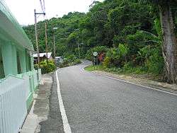
A section of rural Barrio Real in Ponce, Puerto Rico, along Route PR-511. | |
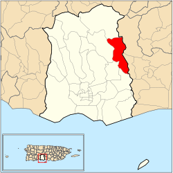 Location of barrio Real within the municipality of Ponce shown in red | |
| Country |
|
| Territory |
|
| Municipality |
|
| Area | |
| • Total | 5.28 sq mi (13.7 km2) |
| • Land | 5.27 sq mi (13.6 km2) |
| • Water | 0.01 sq mi (0.03 km2) |
| Population (2000) | |
| • Total | 3,139 |
| • Density | 596/sq mi (230/km2) |
| Source: 2000 Census | |
Real is one of the 31 barrios of the municipality of Ponce, Puerto Rico. Along with Anón, Coto Laurel, Guaraguao, Quebrada Limón, Marueño, and San Patricio, and the coastal barrios of Canas and Capitanejo, Real is one of the municipality's nine bordering barrios. It borders the municipality of Juana Diaz. It was founded in 1878.[1]
Location
Real is a rural barrio located in the eastern section of the municipality, northeast of the city of Ponce. The toponomy, or origin of the name, is a proper noun related to the "Criadero Real", a barn and slaughterhouse dedicated to the farming of slaughter of cattle.[2]
Boundaries
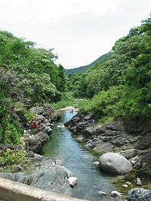
Real is bounded on the North by the hills north of La Compuesta street and Las Mesas Road, on the South by Río Inabon, on the West by the hills west of Rio Inabon, Rio Inabon itself (in the area of just north of Lago Numero 1), and the western and southern shores of Lago Numero 1, the eastern shore of Lago Numero 2, and the northeastern shore of Lago Numero 5, and on the East by Agustinillo Hill, the hills east of Rio Inabon, La Ponceña Brook, and the western shore of Lago Ponceña.[3]
In terms of barrio-to-barrio boundaries, Real is bounded on the north by barrio Anón and by barrios Collores and Callabo of the municipality of Juana Díaz, in the south by barrios Cerrillos and Coto Laurel, in the west by barrios Cerrillos and Maragüez, and in the east by the municipality of Juana Díaz.
Features and demographics
Real has 5.3 square miles (14 km2) of land area and no water area. In 2000, the population of Real was 3,139. The population density in Real was 596 persons per square mile.[4]
The communities of Las Mesas, Ponton, Real Arriba, Haciendas del Real, Mandry, Estancias del Real, Real Abajo, and Sombras del Real are located in barrio Real. There is also a sector of Barrio Real called "Anon", but this should not be confused with Anón the barrio proper.[5]
The main road serving barrio Real is PR-511. PR-14 also briefly brushes the barrio on its southern edge.
The highest point in Barrio Real is Cerro Agustinillo which 1,906 feet.[6]
Landmarks
Real is home to Vista Alegre Lake.
Coordinates: 18°05′12″N 66°33′38″W / 18.0866461°N 66.5606140°W[7]
References
- ↑ Barrios de Ponce. Antepasados Esclavos.(From: Pedro Tomás de Córdoba. Memorias geográficas, históricas, económicas y estadísticas de la Isla de Puerto Rico.) Retrieved 28 November 2014.
- ↑ Government of the Municipality of Ponce. Periodico "El Señorial". Special issue: Carnaval Ponceño 2013. February 2013. Page 17. Ponce, Puerto Rico.
- ↑ General Purpose Population Data, Census 2000. Unidad de Sistemas de Información Geográfica, Área de Tecnología de Información Gubernamental, Oficina de Gerencia y Presupuesto. Gobierno de Puerto Rico. Retrieved October 4, 2010.
- ↑ City Melt Retrieved, February 14, 2010.
- ↑ Historia de Nuestro Barrios: Barrio Anon, Ponce. Page 4, section "Toponimia".
- ↑ Maptest. Government of the Commonwealth of Puerto Rico. General Purpose Population Data, Census 2000. Unidad de Sistemas de Información Geográfica, Área de Tecnología de Información Gubernamental, Oficina de Gerencia y Presupuesto. Gobierno de Puerto Rico. Retrieved 10 November 2011.
- ↑ U.S. Geological Survey Geographic Names Information System: Real Barrio