Prieto River (Ponce, Puerto Rico)
| Prieto River (Ponce, Puerto Rico) | |
|---|---|
| Country | Puerto Rico |
| Basin | |
| Main source |
Barrio Anón 3,920 feet (1,190 m)[1][note 1] |
| River mouth |
Rio Cerrillos 1,381 feet (421 m)[2] |
| Progression | Barrio Anón only |
| River system | Río Bucaná |
| Physical characteristics | |
| Length | 4 km (2.5 mi)[1] |
| Features | |
| Tributaries |
|
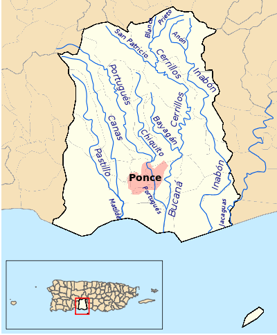
Prieto River is a river in the municipality of Ponce, Puerto Rico. It is located in the northeastern area of the municipality. Forming at an altitude of 3,920 feet (1,190 m), Río Prieto originates at the second highest point of any river in the municipality after Río Inabon. It empties into Río Cerrillos.[3] Together with Río Blanco, Río Prieto is one of the two rivers in Ponce with mouths at the highest elevation (both at 1,381 feet (421 m)).[4] This river is one of the 14 rivers in the municipality.
Origin
Río Prieto has its origin in barrio Anón in Ponce, in the area of Toro Negro State Forest,[5] half a kilometer southwest of Cerro Jayuya and about 0.75 kilometer southeast of Cerro de Punta.[1] It is a tributary of Río Cerrillos and part of the Río Bucana watershed.
Course
Running south from its origin, Río Prieto runs for about 3 kilometers before it is fed by Rio Blanco. Río Prieto winds its way through the mountains paralleling PR-139 for about 1 kilometer before it feeds into Río Cerrillos approximately 800 feet west of the intersection of PR-139 and Camino Cerrillo in Barrio Anón.
See also
Coordinates: 18°08′38″N 66°36′29″W / 18.1438485°N 66.6079505°W[6]
Notes
- ↑ Note: There are different ways of determining a stream's source. Here the two-year-old information from the maps of the Government of Puerto Rico (dated 2009-2010) is used over the 30-year-old (dated 1981) information from the USGS as it is more consistent with 2000-2011 Google images.
References
- 1 2 3 Maptest. Government of the Commonwealth of Puerto Rico. General Purpose Population Data, Census 2000. Unidad de Sistemas de Información Geográfica, Área de Tecnología de Información Gubernamental, Oficina de Gerencia y Presupuesto. Gobierno de Puerto Rico. Retrieved 24 October 2011.
- ↑ Río Anón. US Geographical Survey.
- ↑ Government of the Autonomous Municipality of Ponce. Recursos Naturales. Ponce Ciudad Señorial.
- ↑ US Geographical Survey.
- ↑ Bosques de Puerto Rico: Bosque Estatal de Toro Negro. Hojas de Nuestro Ambiente. July 2008. [Publication/Issue: P-030] Puerto Rico Department of Natural and Environmental Resources. Retrieved 29 July 2013.
- ↑ U.S. Geological Survey Geographic Names Information System: Río Prieto
External links
- USGS Hydrologic Unit Map – Caribbean Region (1974)