Rötteln Castle
| Rötteln Castle (Burg Rötteln) | |
|---|---|
| Lörrach, Baden-Württemberg, Germany | |
|
Aerial view at Rötteln Castle | |
| Type | Castle |
| Site information | |
| Owner | Government of Baden-Württemberg |
| Open to the public | yes (March–October) |
| Condition | Ruins survive |
| Site history | |
| Built | c. 11th Century |
| Built by | Lords of Rötteln |
| In use | 1000's–1678 |
| Materials | Stone (11th century architecture) |
| Demolished | 29 June 1678 |
| Battles/wars |
Thirty Years War Franco-Dutch War |
| Events | 1356 Basel earthquake |
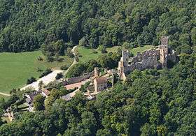
Rötteln Castle (German: Burg Rötteln), located above the Lörrach suburb of Haagen, lies in the extreme southwest corner of the German state of Baden-Württemberg just 10 kilometres (6 miles) North-East of the Swiss City of Basel. The fortification was one of the most powerful in the southwest, and today is the third largest castle ruin in Baden.[1]
The ruins of the castle are situated on a widely visible forested hill 422 metres (1,385 ft) above sea level. The keep lies on a spur projecting from the steep sided east side of the lower Wiese valley.
History

The castle has probably existed since the beginning of the 11th century. In the year 1102 is the first documented mention of a lord of Rötteln, one Dietrich von Rötteln, the bailiff of St. Albans near Basel. This year is also considered the date of the founding of the city of Lörrach. In 1204 Dietrich III of Rötteln died, having amassed a large holding in the Wiese valley. His sons held high offices; Walter I was the Kapitular (a priest who is authorized to say the mass in a cathedral and perform other duties of a bishop) of Konstanz and Basel, Luithold I was the bishop of Basel, Konrad I was the founder of the city of Schopfheim, which was important to the later formation of the Markgräflerland. The first documented mention of the castle itself is from the year 1259.
Luithold II von Rötteln, the last male of his line, gave the lordship of Rötteln to the Margrave Rudolf I of Hachberg-Sausenberg and his heiress Agnes von Rötteln in the year 1311. As a result, the Margrave of Hachberg-Sausenberg, based in Emmendingen at Hochburg Castle, also became lord of the former domain of Rötteln. The Margrave then moved from Sausenburg to Rötteln Castle to more easily administer his new domain and appointed a bailiff to oversee Sausenburg
Luithold II von Rötteln died on May 19, 1316, and the passing of Rötteln to Hachberg-Sausenburg was an important step in the eventual formation of the Markgräflerland. In 1332 the castle was besieged by the people of Basel because the Margrave Rudolf II stabbed the mayor of Basel during an argument. The conflict was resolved at the last moment through an agreement to settle the argument. Arrowheads, crossbow bolts, and other finds near the castle attest to this siege.
The Basel earthquake of 1356 destroyed large portions of the city, and the castle suffered severe damage.
In 1444 the domain of Badenweiler passed from the last Count of Freiburg, John, to the son of Margrave Wilhelm, Rudolf IV von Hachberg-Sausenberg. The combination of the three dominions, Rötteln, Sausenburg, and Badenweiler formed the foundation of the Markgräflerland.
In 1503 the castle came into the possession of the Margrave of Baden. In 1525 (during the German Peasants' War) revolting peasants briefly took possession of the castle.
From 1618 to 1648 during the Thirty Years War the castle was occupied by both Swedish and Imperial forces.
During the Franco-Dutch War, on June 29, 1678, the castles of Rötteln, Sausenburg, and Badenweiler were destroyed by the army of the French Marshall François de Créquy. The castle ruins were thereafter used as a source of building stone (quarry).
The Black Forest Society of Baden(Schwarzwaldverein) began to survey the ruins in 1884 in order to preserve it. Since 1926 this has been the concern of the Röttelnbund e.V. club based in Lörrach-Haagen. Today the ruins have been restored to approximately their condition after their destruction in 1678.
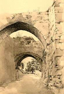
A drawing by local artist August Heckmann shows the southern gate of the castle around 1945.
Location
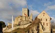
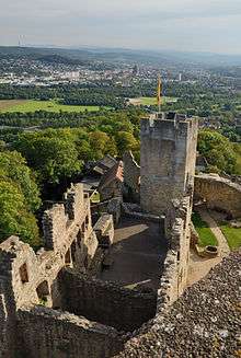
The site of the castle extends from northwest to southwest over a distance of almost 300 meters. The widely spread castle can be roughly divided into the fore-castle and upper castle. To the west a bastion-like point extends for the placement of light artillery. Passage from the fore-castle to the upper castle is by means of a drawbridge. The upper castle with its powerful keep is the oldest part of the castle. Archaeological finds from the castle and grounds are on display in the museum in the courtyard of the castle.
The "Green Tower", at the highest point of the keep, offers a particularly fine view of Lörrach, the Wiese valley and several Swiss mountain peaks. The castle ruins are the most notable landmark of the border town. The Röttler Burgfestspiele, an open air live theater in the castle courtyard, has operated annually each summer since 1968.
The lower castle is open year round and the keep and museum are open in the summer and on weekends in the winter. Tours are available with prior reservations. In addition to the small museum, there is a Burgschänke or traditional restaurant / pub in the bailey.
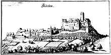
The oldest surviving depiction of Rötteln castle is an illustration from Sebastian Münster's Cosmographia from the year 1562. Another well known contemporary illustration by Matthäus Merian shows the castle in 1644.
Bibliography
- Helmut Bender u. a.: Burgen im südlichen Baden. Verlag Karl Schillinger, Freiburg i. Br. 1979, ISBN 3-921340-41-1.
- Heinz Heimgartner: Burgruine Rötteln, Verlag Röttelnbund e. V.. 1964.
- Jürgen Krüger: Burg Rötteln. Deutscher Kunstverlag München, Berlin 2006, ISBN 3-422-02049-7.
See also
Notes
External links
| Wikimedia Commons has media related to Rötteln Castle. |
| Wikivoyage has a travel guide for Rötteln Castle. |
- English informations about Rötteln Castle on the Homepage of the state heritage agency Staatliche Schlösser und Gärten
- English informations about Rötteln Castle on the Homepage of Basel Tourism
- English informations about Rötteln Castle on the Homepage of the City of Lörrach
- English informations about Rötteln Castle on the Homepage alamanicus.com
- Burgfestspiele Rötteln (German)
- Burg Rötteln: Image gallery
- Burg Rötteln at the site Burgenwelt.de/ (German)
- Historical information (German)
Coordinates: 47°38′18″N 07°40′05″E / 47.63833°N 7.66806°E
Castles, Fortresses and Palaces in Germany - Baden-Württemberg | ||
|---|---|---|
| Administrative Region |  | |
| Freiburg | ||
| Karlsruhe | ||
| Stuttgart |
| |
| Tübingen |
| |