RAF Rackheath
| RAF Rackheath USAAF Station 145 .png) | |||||||||||
|---|---|---|---|---|---|---|---|---|---|---|---|
| Near Norwich, Norfolk in England | |||||||||||
|
Aerial Photo of Rackheath Airfield - 9 July 1946 | |||||||||||
 RAF Rackheath Shown within Norfolk | |||||||||||
| Coordinates | 52°40′28″N 001°22′43″E / 52.67444°N 1.37861°ECoordinates: 52°40′28″N 001°22′43″E / 52.67444°N 1.37861°E | ||||||||||
| Type | Royal Air Force station | ||||||||||
| Code | RK | ||||||||||
| Site information | |||||||||||
| Owner | Air Ministry | ||||||||||
| Operator |
Royal Air Force United States Army Air Forces | ||||||||||
| Site history | |||||||||||
| Built | 1943 | ||||||||||
| In use | 1944-1945 | ||||||||||
| Airfield information | |||||||||||
| Elevation | 31 metres (102 ft) AMSL | ||||||||||
| |||||||||||

Royal Air Force Rackheath or more simply RAF Rackheath is a former Royal Air Force station located near Rackheath, 5 miles (8.0 km) north east of Norwich, Norfolk, England.
History
Airfield construction began in 1943 for the United States Army Air Forces Eighth Air Force and followed the lines of other heavy bomber bases with a main runway of 2,000 yards (1,800 m) and two auxiliary runways of 1,400 yards (1,300 m) each. The perimeter track was 2.7 miles (4.3 km) in length and this and the runways had a concrete screed finish. Mark II airfield lighting was installed, two T-2 hangars were erected for major aircraft maintenance, and dispersed temporary building accommodation provided for some 2.400 men in the wooded countryside of the estate to the south-west of the airfield. During construction, 556,000 cubic yards (425,000 m3) of soil were excavated, 14,000 yards (13,000 m) of soakaway drains installed and 504,000 yards (461,000 m) super of concrete laid. A major overhead power line had to be put underground to clear the flying approaches.
USAAF use
The airfield was laid out on agricultural land between the two settlements of Rackheath Parva and Rackheath Magna.
The airfield was given USAAF designation Station 145.
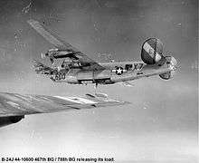
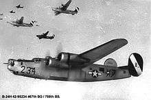
467th Bombardment Group (Heavy)
The airfield was opened on 11 March 1944 and was used by the 467th Bombardment Group (Heavy), arriving from Wendover AAF Utah. The 467th was assigned to the 96th Combat Bombardment Wing, and the group tail code was a "Circle-P". Its operational squadrons were:
- 788th Bombardment Squadron (X7)
- 789th Bombardment Squadron (6A)
- 790th Bombardment Squadron (Q2)
- 791st Bombardment Squadron (4Z)
The group flew the Consolidated B-24 Liberator as part of the Eighth Air Force's strategic bombing campaign. The 467th began operations on 10 April 1944 with an attack by thirty aircraft on an airfield at Bourges in central France.
In combat, the unit served chiefly as a strategic bombardment organization, attacking the harbor at Kiel, chemical plants at Bonn, textile factories at Stuttgart, power plants at Hamm, steel works at Osnabrück, the aircraft industry at Brunswick, and other objectives.
In addition to strategic operations, it was engaged occasionally in support and interdiction missions. It bombed shore installations and bridges near Cherbourg on D-Day, 6 June 1944. It struck enemy troop and supply concentrations near Montreuil on 25 July 1944 to assist the Allied drive across France.
In September, over two weeks the bombers flew gasoline from Rackheath to a forward base at Clastres in France for use by the US mechanized forces. Attacked German communications and fortifications during the Battle of the Bulge, December 1944-January 1945. To assist the Allied assault across the Rhine in March 1945 it attacked enemy transportation.
The group flew its last combat mission on 25 April and returned to the US to Sioux Falls AAF South Dakota during June and July 1945. Subsequently the 467th was redesignated as the 467th Bombardment Group (Very Heavy) with Boeing B-29 Superfortresses in preparation for the planned invasion of Japan. The 467th was inactivated on 4 August 1946.[1][2]
Current use
With the end of the war, the airfield was closed in 1945 and the airfield site returned to farming. Very little of the runways, perimeter track, or hardstands remain. Most of the concrete has been broken up for aggregate.
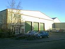
The technical site has become the Rackheath Industrial Estate with several of the wartime buildings being modified or extended, and used for light industry. The major access road on the estate was named Wendover Road to commemorate the airbase in the US where the 467th Bomb Group was formed. Other roads carry related names including one after Albert Shower the base commander and "Witchcraft Way" after an aircraft of the group.
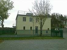
The control tower has been converted to use as an administrative building. The T-2 hangar nearby is virtually beyond recognition as compared to how it looked in 1943. Brickwork has been added to the front and the whole building has been repainted cream and green. Inside the building the roof girders appear to be original and identical to those seen on photographs taken in 1944. The other hangar on the eastern side of the airfield was dismantled many years ago.
A memorial to the 467th Bomb Group consisting of a plaque and a bench was dedicated in 1983, and is situated near the village sign (featuring a B-24) on the Salhouse Road, adjacent to the Holy Trinity Church.
See also
References
![]() This article incorporates public domain material from the Air Force Historical Research Agency website http://www.afhra.af.mil/.
This article incorporates public domain material from the Air Force Historical Research Agency website http://www.afhra.af.mil/.
Citations
- ↑ Maurer 1980, p. 00.
- ↑ Freeman 2001, p. 00.
Bibliography
- Freeman, R. Airfields of the Eighth - Then and Now. After the Battle. London, UK: Battle of Britain International Ltd., 2001. ISBN 0-9009-13-09-6.
- Freeman, Roger A. (1991) The Mighty Eighth: The Colour Record. Cassell & Co. ISBN 0-304-35708-1
- Maurer, M. Air Force Combat Units Of World War II. USAF Historical Division. Washington D.C., USA: Zenger Publishing Co., Inc, 1980. ISBN 0-89201-092-4.
- Rackheath www.controltowers.co.uk
- Rackheath at http://mighty8thaf.preller.us
- USAAS-USAAC-USAAF-USAF Aircraft Serial Numbers--1908 to present
External links
| Wikimedia Commons has media related to RAF Rackheath. |
Royal Air Force portal | ||
| Formations and units |  | |
| Branches and components | ||
| Reserve forces | ||
| Associated civil organizations | ||
| Equipment | ||
| Personnel | ||
| Appointments | ||
| Symbols and uniform | ||