Iernut
| Iernut | ||
|---|---|---|
| Town | ||
|
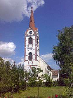
Reformed church, begun in 1486. | ||
| ||
 Iernut Location of Iernut | ||
| Coordinates: 46°27′13″N 24°14′0″E / 46.45361°N 24.23333°ECoordinates: 46°27′13″N 24°14′0″E / 46.45361°N 24.23333°E | ||
| Country |
| |
| County | Mureş County | |
| Status | Town | |
| Government | ||
| • Mayor | Ioan Nicoara (National Liberal Party) | |
| Area | ||
| • Total | 106.36 km2 (41.07 sq mi) | |
| Population (2002) | ||
| • Total | 9,523 | |
| Demonym(s) | iernutean, iernuteancă (ro) | |
| Time zone | EET (UTC+2) | |
| • Summer (DST) | EEST (UTC+3) | |
| Website | http://www.primariaiernut.ro/ | |
Iernut (Hungarian: Radnót, pronounced [ˈrɒdnoːt]) is a town in Mureş County, central Transylvania, Romania. It administers eight villages: Cipău (Maroscsapó), Deag (Marosdég), Lechinţa (Maroslekence), Oarba de Mureş (Marosorbó), Porumbac (Porumbáktanya), Racameţ (Józseftanya), Sălcud (Szélkút) and Sfântu Gheorghe (Csapószentgyörgy).
Demographics
| Historical population | ||
|---|---|---|
| Year | Pop. | ±% |
| 1992 | 9,719 | — |
| 2002 | 9,833 | +1.2% |
| 2011 | 8,373 | −14.8% |
| Source: Census data | ||
The 2011 census revealed the following demographic data:[1]
- Romanians (76.55%)
- Hungarians (13.36%)
- Roma (9.84%)
- others (0.18%)
Main sights
- The Reformed church (built between 1486-1593)
- Kornis-Rakóczi-Bethlen Castle (built in 1545)
- The two lakes near the city
- Mureş River
- Lupoaica
- Old Buildings
References
| Wikimedia Commons has media related to Iernut. |
This article is issued from Wikipedia - version of the 6/6/2016. The text is available under the Creative Commons Attribution/Share Alike but additional terms may apply for the media files.


