Rangiroa (commune)
This article is about the French Polynesian commune. For the atoll in the commune, see Rangiroa.
| Rangiroa | |
|---|---|
|
Avatoru Pass, atoll of Rangiroa | |
 Location of Rangiroa in the Tuamotu Archipelago | |
| Coordinates: 14°57′01″S 147°39′04″W / 14.9504°S 147.6511°WCoordinates: 14°57′01″S 147°39′04″W / 14.9504°S 147.6511°W | |
| Country | France |
| Overseas collectivity | French Polynesia |
| Government | |
| • Mayor (2008–2014) | Teina Maraeura |
| Area | 139 km2 (54 sq mi) |
| Population (2007)1 | 3,210 |
| • Density | 23/km2 (60/sq mi) |
| INSEE/Postal code | 98740 / |
| 1 Population without double counting: residents of multiple communes (e.g., students and military personnel) only counted once. | |
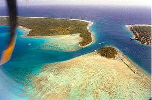
Rangiroa is a commune of French Polynesia in the archipelago of the Tuamotu Islands. The commune includes four islands: Rangiroa, Tikehau, Mataiva and Makatea. The chef-lieu is the atoll of Rangiroa and the chief-town is Avatoru.
Geography
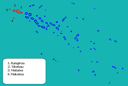
Commune of Rangiroa
The commune is composed of three atolls and one island:
| Atoll or island | Main village | Population 2007[1] | Area above water(km²) | Lagoon (km²) | Coordinates |
|---|---|---|---|---|---|
| Rangiroa1 | Avatoru | 2,473 | 79 | 1,446 | 15°07′S 147°37′W / 15.117°S 147.617°W |
| Tikehau1 | Tuherahera | 507 | 20 | 400 | 15°01′S 148°10′W / 15.017°S 148.167°W |
| Mataiva1 | Pahua | 204 | 16 | 25 | 14°53′S 148°40′W / 14.883°S 148.667°W |
| Makatea1 | Moumu | 61 | 24 | - | 15°51′S 148°15′W / 15.850°S 148.250°W |
| Rangiroa commune | Avatoru | 3,245 | 139 | 1,871 |
See also
References
- ↑ Recensement de 2007, statistiques Publisher: Institut statistique de la Polynésie Française (in French). Accessed 16 February 2010
External links
| Wikimedia Commons has media related to Rangiroa. |
This article is issued from Wikipedia - version of the 11/25/2015. The text is available under the Creative Commons Attribution/Share Alike but additional terms may apply for the media files.