Rātana pā
| Ratana Community Rātana pā | |
|---|---|
| Town | |
|
The temple at Rātana Pā | |
 Ratana Community | |
| Coordinates: 40°02′24″S 175°10′40″E / 40.04000°S 175.17778°ECoordinates: 40°02′24″S 175°10′40″E / 40.04000°S 175.17778°E | |
| Country | New Zealand |
| Region | Manawatu-Wanganui |
| Territorial authority | Rangitikei District |
| Government | |
| • Mayor | Andy Watson |
| • MP | Ian McKelvie |
| Population (2013 census[1]) | |
| • Total | 327 |
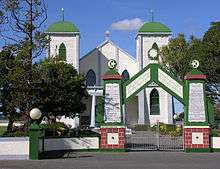
Rātana pā, or Ratana Community,[lower-alpha 1] is a town in the North Island of New Zealand, near Whanganui and Marton in the Manawatu-Wanganui Region, which developed around the Rātana church there. It is a site of pilgrimage for the Maori followers of the Rātana faith.[2] Due to the importance of the Rātana movement in New Zealand politics, leading New Zealand politicians often attend annual gatherings at Rātana pā.
25 January
Each year on 25 January, members of the Rātana Church converge to Rātana Pā to celebrate the birth of its founder Tahupōtiki Wiremu Rātana. This annual gathering lasts for a week. The highlight of the week is the Temple Service on 25 January. Usually, Members of Parliament (MPs) converge to the Pa on 24 January to talk and gain Māori votes for election time.
Geography
Whanganui is located 20 km to the northwest and Marton is located 19 km to the east.
Government and politics
Local government
As part of the Rangitikei District, the current Mayor of Rangitikei since 2013 is Andy Watson.[3]
Rātana pā forms part of the Turakina ward of the Rangitikei District Council, which elects one of the eleven district councillors. The one representative of the ward is Soraya Peke-Mason.[4] The mayor and councillors are all due for re-election in October 2016.[5]
National government
Rātana pā, like the rest of the Rangitikei District, is located in the general electorate of Rangitīkei and in the Māori electorate of Te Tai Hauāuru.[6] Rangitīkei is a safe National Party seat since the 1938 election with the exception of 1978–1984 when it was held by Bruce Beetham of the Social Credit Party. Since 2011 it is held by Ian McKelvie.[7]
Te Tai Hauāuru is a more volatile seat, having been held by three different parties since 1996, i.e. New Zealand First, the Māori Party and the Labour Party.[8] Since 2014 it is held by Adrian Rurawhe of the Labour Party.[9]
Education
The town has one primary school: Te Kura o Ratana. It is a state-integrated coeducational school with a roll of 33 students.[10] The nearest secondary schools are in Whanganui and Marton.
Demographics
| Historical population | ||
|---|---|---|
| Year | Pop. | ±% p.a. |
| 2001 | 423 | — |
| 2006 | 366 | −2.85% |
| 2013 | 327 | −1.60% |
| Source: [1] | ||
Ratana Community[lower-alpha 1] had a population of 327 according to the 2013 census. This is a decrease of 39, or 10.7 percent, since the 2006 census. There were 102 occupied dwellings, 15 unoccupied dwellings, and no dwellings under construction.[1]
Of the residential population, 138 (42.2%) were male compared to 48.7% nationally, and 192 (57.8%) were female, compared to 51.3% nationally. The district had a median age of 34.5 years, 3.5 years below the national median age of 38.0 years. People aged 65 and over made up 15.6% of the population, compared to 14.3% nationally, and people under 15 years made up 22.9%, compared to 20.4% nationally.[1]
The community's ethnicity is made up of (national figures in brackets): 96.9% Māori (14.9%), 9.4% European (74.0%), 3.1% Pacific Islanders (7.4%), 0.0% Asian (11.8%), 0.0% Middle Eastern, Latin American or African (1.2%), and 0.0% Other (1.7%).[1]
Ratana Community had an unemployment rate of 17.8% of people 15 years and over, compared to 7.4% nationally. The median annual income of all people 15 years and over was $19,000, compared to $28,500 nationally. Of those, 50.0% earned under $20,000, compared to 38.2% nationally, while 14.1% earned over $50,000, compared to 26.7% nationally.[1]
Transport
State Highway 3 ![]() is located 2 km to the northeast of Rātana pā. This national state highway, connects Woodville (25 km east of Palmerston North) and Hamilton via New Plymouth.
is located 2 km to the northeast of Rātana pā. This national state highway, connects Woodville (25 km east of Palmerston North) and Hamilton via New Plymouth.
InterCity runs three daily and six non-daily services at the Ratana Turn Off stop. These include Palmerston North–Auckland, Wellington–New Plymouth and Auckland–Palmerston North.[11]
The nearest airport is Whanganui Airport, located 22 km to the northwest of the town.
Table footnotes
- 1 2 As defined by Statistics New Zealand.[1]
References
- 1 2 3 4 5 6 7 "2013 Census QuickStats about a place: Ratana Community". Statistics New Zealand. Retrieved 2 February 2016.
- ↑ Newman, Keith. "The Founding of a Faith". New Zealand Historic Places Trust. Retrieved 2 June 2012.
- ↑ Wallis, Anna (14 October 2013). "Watson wins Rangitikei chain". Wanganui Chronicle – nzherald.co.nz. Retrieved 1 February 2016.
- ↑ "Councillors". Rangitikei District Council. Retrieved 2 February 2016.
- ↑ "Local Electoral Act 2001". Parliamentary Counsel Office. Retrieved 2 February 2016.
- ↑ "Find my Electorate". Electoral Commission. Retrieved 1 February 2016.
- ↑ "Rangitīkei Electorate Profile". New Zealand Parliament. 30 September 2012. Retrieved 1 February 2016.
- ↑ "Te Tai Hauāuru Electorate Profile". New Zealand Parliament. 30 September 2012. Retrieved 1 February 2016.
- ↑ "Rurawhe, Adrian". New Zealand Parliament. 4 December 2015. Retrieved 1 February 2016.
- ↑ "Te Kura o Ratana – School Population". Ministry of Education. 1 July 2015. Retrieved 2 February 2016.
- ↑ "Ratana Turn Off – Bus Timetable". InterCity. 1 February 2016. Retrieved 2 February 2016.
External links
The Rangitikei District, Manawatu-Wanganui, New Zealand | |||||||||||||
|---|---|---|---|---|---|---|---|---|---|---|---|---|---|
| Main towns and meshblocks | |||||||||||||
| Minor towns and localities | |||||||||||||
| Schools |
| ||||||||||||
| Electorates |
| ||||||||||||
| Members of Parliament |
| ||||||||||||
| Mayor (Council) |
| ||||||||||||
| Bodies of water | |||||||||||||
| Transportation | |||||||||||||
| Other | |||||||||||||