Rector Street (IRT Broadway–Seventh Avenue Line)
| Rector Street | |||||||
|---|---|---|---|---|---|---|---|
| New York City Subway rapid transit station | |||||||
|
Uptown platform | |||||||
| Station statistics | |||||||
| Address |
Rector Street & Greenwich Street New York, NY 10006 | ||||||
| Borough | Manhattan | ||||||
| Locale | Financial District | ||||||
| Coordinates | 40°42′29″N 74°00′47″W / 40.708°N 74.013°WCoordinates: 40°42′29″N 74°00′47″W / 40.708°N 74.013°W | ||||||
| Division | A (IRT) | ||||||
| Line | IRT Broadway–Seventh Avenue Line | ||||||
| Services |
1 | ||||||
| Transit connections |
| ||||||
| Structure | Underground | ||||||
| Platforms | 2 side platforms | ||||||
| Tracks | 2 | ||||||
| Other information | |||||||
| Opened | July 1, 1918 | ||||||
| Closed | September 11, 2001 | ||||||
| Rebuilt | September 15, 2002 | ||||||
| Wireless service |
| ||||||
| Traffic | |||||||
| Passengers (2015) |
3,042,815[2] | ||||||
| Rank | 170 out of 422 | ||||||
| Station succession | |||||||
| Next north |
Chambers Street: 1 Cortlandt Street: no regular service | ||||||
| Next south |
South Ferry loops: 1 South Ferry (2009 station): no regular service | ||||||
| |||||||
| |||||||
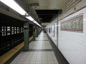


Rector Street is a station on the IRT Broadway–Seventh Avenue Line of the New York City Subway. Located at the intersection of Rector Street and Greenwich Street in Lower Manhattan, it is served by the 1 train at all times.
Station layout
| G | Street level | Exit |
| P Platform level |
Side platform, doors open on the right | |
| Northbound | ← ← | |
| Southbound | → → | |
| Side platform, doors open on the right | ||
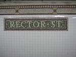
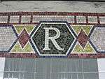
This underground station, opened on July 1, 1918, has two tracks and two side platforms. Each platform has mosaic trim line and name tablets of mostly green and brown. The tiles are painted light green below the "R" tablets.
This station has five fare control areas and there are no crossover between the uptown and downtown sides. On the northern end of the downtown platform, there are two High Entry/Exit Turnstiles leading to one street stair that goes up to the northwest corner of Rector and Greenwich Streets coming from two high entrance turnstiles directly on the platform. In the middle of the platform, two staircases lead up to a tiny intermediate level where a single exit-only turnstile leads to a staircase that goes up midblock on Greenwich Street between Rector and Edgar Streets. The last fare control area for this side at the south end has HEET turnstiles leading to a single staircase that goes up to just south of Edgar Street in a plaza where Greenwich Street ends at the foot of the Brooklyn–Battery Tunnel.
Directly across the street from this area, there are two street stairs that lead down to two HEET turnstiles on the uptown platform. A single staircase at the northern end of this platform leads to the tiny, full-time mezzanine. It has a turnstile bank, token booth, and one street stair that leads to the north corner of Rector and Greenwich Streets.
After the September 11, 2001 attacks, the subway tunnels around Cortlandt Street collapsed, and the line was closed until September 15, 2002. During the intervening period, the station was renovated.
Due to water damage to South Ferry caused by Hurricane Sandy, all 1 trains terminated at this station until April 4, 2013, when the former South Ferry Loop terminal station reopened.[3]
References
- ↑ "NYC Subway Wireless – Active Stations". Transit Wireless Wifi. Retrieved 2016-05-18.
- ↑ "Facts and Figures: Annual Subway Ridership". Metropolitan Transportation Authority. Retrieved 2016-04-19.
- ↑ http://www.mta.info/nyct/service/SouthFerryStationReopenApril2013.htm
External links

-
 Media related to Rector Street (IRT Broadway – Seventh Avenue Line) at Wikimedia Commons
 - nycsubway.org – IRT West Side Line: Rector Street
- Station Reporter – 1 Train
- Rector Street entrance from Google Maps Street View
- South entrance near Brooklyn Battery Tunnel from Google Street View
- Platforms from Google Street View