Red Deer River
| Red Deer River | |
|---|---|
|
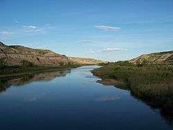
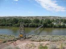
Red Deer River in Drumheller, Alberta | |
| Country |
|
| Basin | |
| Main source |
Sawback Range, Red Deer Lakes 2,200 m (7,200 ft) 51°31′56″N 116°02′31″W / 51.53221°N 116.04201°W |
| River mouth |
South Saskatchewan River near Empress 579 m (1,900 ft) 50°55′23″N 109°53′42″W / 50.92315°N 109.89493°WCoordinates: 50°55′23″N 109°53′42″W / 50.92315°N 109.89493°W |
| Basin size | 45,100 km2 (17,400 sq mi) |
| Physical characteristics | |
| Length | 724 km (450 mi) |
| Discharge |
|
The Red Deer River is a river in Alberta and a small portion of Saskatchewan, Canada. It is a major tributary of the South Saskatchewan River and is part of the larger Saskatchewan-Nelson system that empties into Hudson Bay.[2]
Red Deer River has a total length of 724 kilometres (450 mi) and a drainage area of 45,100 square kilometres (17,400 sq mi). Its mean discharge is 70 cubic metres per second (2,500 cu ft/s).[1]
The river got its name from the translation of Was-ka-soo which means "elk river" in the Cree.
Communities located along the Red Deer River include Sundre, Red Deer, Drumheller, and Empress, The city of Brooks, as well as Dinosaur Provincial Park, are also located in the Red Deer River Basin. A glacial flood about 18,000 years ago eroded out a portion of this basin and apparently all or most of the scenic badlands bearing the dinosaur and other Cretaceous fossils.
History
Joseph Tyrrell discovered a huge coal seam here in 1883, besides large dinosaur skeletons.[3]
2013 Alberta flood
In June 2013, Alberta, Canada, experienced heavy rainfall that triggered catastrophic flooding throughout much of the southern half of the province along the Bow, Elbow, Highwood, Oldman, and Red Deer rivers and tributaries. Twenty-four municipalities declared local states of emergency as water levels rose and numerous communities were placed under evacuation orders.[4] The Royal Canadian Mounted Police stated four people may have drowned near High River.[5] Over 100,000 people have been displaced throughout the region.[6]
Course
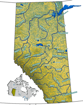

The river originates on the eastern slopes of the Canadian Rockies, in the Sawback Range near the Skoki Valley inside Banff National Park, and then flows east through the mountains and foothills region. It turns north-east before Sundre and flows to an artificial Reservoir named Gleniffer Lake (Alberta), created in 1983 by the Dickson Dam and keeps this heading to the city of Red Deer, where it turns east, and then south before Stettler. It flows south with its valley protected by provincial and regional parks such as Tolman Badlands Heritage Rangeland, Dry Island Buffalo Jump Provincial Park, Dry Island Corridor and Midland Provincial Park. At Drumheller it has a south-east direction, and while it flows through Dinosaur Provincial Park it turns east and flows to the Alberta/Saskatchewan border, which it crosses at Empress. It flows for 16 kilometres (10 mi) through Saskatchewan before it merges into the South Saskatchewan River.
Tributaries
|
|
The waters of Ewing Lake, Little Fish Lake also flow into the Red Deer River.[8][9]
Fish species
Sport fish include: northern pike, sauger, lake whitefish, yellow perch, burbot, lake sturgeon, mountain whitefish, goldeye, brown trout, bull trout, rainbow trout, brook trout, and cutthroat trout.
Other fish include: emerald shiner, river shiner, spottail shiner, flathead chub, longnose dace, quillback carpsucker, longnose sucker, white sucker, shorthead redhorse, silver redhorse, perch, spoonhead sculpine, lake chub, pearl dace, northern redbelly dace, finescale dace, fathead minnow, muskellunge, and brook stickleback.
Gallery
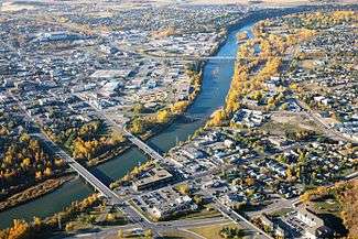 Flowing through the city of Red Deer
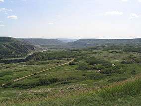
Environmental concerns
Pipeline leaks
The Red Deer River is the water source for the City of Red Deer, Alberta and the surrounding area. Pipelines cross under the river and there have been leaks disrupting access to potable water.[12] Increased water flow of the Red Deer River system during heavy rainfall in June 2008 eroded supporting soil, freely exposing a section of Pembina Pipeline Corporation's Cremona crude oil pipeline to the Red Deer River currents. About 75 to 125 barrels of crude oil flowed upstream from the breakpoint under a Red Deer River channel, leaving an oily sheen on Gleniffer Reservoir and 6800 kilograms (15 000 lbs) of oil-soaked debris.[13][14] The remediation was not completed until 2011.[15]
Heavy rains in early June 2012 caused a similar but larger leak on a Plains Midstream Canada 46-year-old pipeline on a Red Deer River tributary, Jackson Creek, Alberta (51°52'19" 114°36'23") near Gleniffer Lake (Alberta) and Dickson Dam,[16] which spilled approximately 1000 and 3000 barrels (160,000-475,000 litres) of light sour crude into the Red Deer River.[15][17]
See also
- List of crossings of the Red Deer River
- List of longest rivers of Canada
- List of rivers of Alberta
- List of rivers of Saskatchewan
- Glacial Lake Bassano
References
- 1 2 Atlas of Canada. "Rivers in Canada". Archived from the original on 2007-02-02. Retrieved 2007-05-01.
- ↑
- ↑ Barnes, Michael (1986). Fortunes in the Ground. Erin, Ontario: The Boston Mills Press. p. 198. ISBN 091978352X.
- ↑ Wood, James (2013-06-22). "Harper, Redford promise to help". Calgary Herald. p. A5.
- ↑ Frisk, Adam; Tucker, Ericka; Stone, Laura (June 21, 2013). "RCMP: 4 possibly dead in Alberta floods as Calgary continues evacuation". Global News. Retrieved June 21, 2013.
- ↑ "4 feared dead from Alberta floods". Canadian Broadcasting Corporation. June 21, 2013. Retrieved June 21, 2013.
- ↑
- ↑ "Natural Resources Canada-Canadian Geographical Names (Red Deer River)". Retrieved 2014-08-29.
- ↑ "Atlas of Canada Toporama". Retrieved 2014-08-29.
- ↑ http://www.ab-conservation.com/go/default/custom/uploads/reportseries2/Asses-Sprt-Fish-Dist-Rel-Abun-LRDR,AB-PhII.pdf
- ↑ http://www.waskasoopark.ca/Fishes_of_the_Red_Deer_River_and_Surrounding_Lakes.pdf
- ↑ http://www.cbc.ca/m/rich/business/story/2012/06/08/calgary-sundre-oil-spill.html. Missing or empty
|title=(help) - ↑ Brian Temple; Doug Buechler; Dave Grzyb; Murray Barber; Jenny Miller; Phil Hendy; Mike Bevan (February 11, 2009). ERCB Investigation Report: Pembina Pipeline Corporation, Crude Oil Pipeline Failure, June 15, 2008 (.pdf) (Report). Energy Resources Conservation Board. Retrieved 2012-06-16. The pipeline, leased to Pembina, was built in 1959.
- ↑ "Oil leaks into popular Alberta lake: Company previously fined in B.C. for pipeline rupture, spill in 2000". CBC. June 6, 2008. Retrieved 2012-06-16.
- 1 2 Bob Weber (June 14, 2012). "Alberta pressured to include leaks in environmental monitoring plan". Financial Post. Retrieved 2012-06-16.
- ↑ Name: Jackson Creek
- ↑ Stephen Ewart (June 16, 2012). "Ewart: Calls growing for probe of aging pipeline system: Recent spills highlight ongoing risk". Calgary Herald. Retrieved 2012-06-16.