Refinery Row (Edmonton)
Coordinates: 53°32′28″N 113°23′16″W / 53.54111°N 113.38778°W

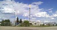
Refinery Row is the unofficial name[1][2][3][4] given to the concentration of oil refineries in west Sherwood Park,[5] Strathcona County, Alberta, just east of the city of Edmonton.
The area is roughly bounded on the south by the Sherwood Park Freeway (Highway 100), on the north by the North Saskatchewan River and Yellowhead Trail (Highway 16), on the east by Anthony Henday Drive (Highway 216), and on the west by 50 Street. Other major roads that run through the area include: 34 Street, 17 Street NW, and 101 Avenue/Baseline Road.
The district is dominated by two refineries:
- the Strathcona Refinery (Imperial Oil), can process 187,000 barrels (29,700 m3) of crude oil per day;[6] and
- the Suncor Edmonton Refinery (Suncor Energy), which can process 135,000 barrels per day (21,500 m3/d)[7]
The other main refineries in the Edmonton area are also located in Strathcona County, in a separate concentration around Scotford, Alberta.
See also
- Alberta's Industrial Heartland, aka "Upgrader Alley"
- List of oil refineries (worldwide)
References
- ↑ "Workers injured in Edmonton plant explosion out of hospital". CBC News. October 24, 2008. Retrieved 2010-01-26.
- ↑ "Mayor's speech". Strathcona County. October 17, 2007. Retrieved 2010-02-02.
- ↑ J. Hall (September 12, 2007). "Work stoppages hit refinery row, oilsands". Edmonton Journal. canada.com. Retrieved 2010-01-26.
- ↑ Lawrence Herzog (July 26, 2007). "The 1987 tornado was a turning point". Edmonton Real Estate Weekly. Retrieved 2010-01-26.
- ↑ Strathcona County 2008 Map
- ↑ Imperial Oil - Strathcona Refinery
- ↑ Suncor - Refining and Marketing