Sherwood Park Freeway
| Sherwood Park Freeway | ||||
|---|---|---|---|---|
|
Sherwood Park Freeway highlighted | ||||
| Route information | ||||
|
Maintained by the City of Edmonton & Alberta Transportation | ||||
| Length: | 7.1 km[1] (4.4 mi) | |||
| History: |
1964 (construction begins)[2] 1968 (completed)[3] | |||
| Major junctions | ||||
| West end: | 71 Street in Edmonton | |||
| East end: |
| |||
| Location | ||||
| Municipalities: | Strathcona County | |||
| Major cities: |
Edmonton Sherwood Park | |||
| Highway system | ||||
|
Provincial highways in Alberta
| ||||
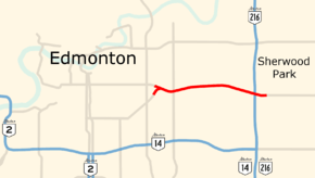
Sherwood Park Freeway is a 7.1 km (4.4 mi) freeway that connects east Edmonton to Sherwood Park in Alberta, Canada. The eastern half of the route from 34 Street to Anthony Henday Drive is designated as Highway 100 by Alberta Transportation for administrative purposes, but is not signed as such at any point along the route.[4] The western segment is under the jurisdiction of the City of Edmonton. The Highway 100 portion is only 4.2 km (2.6 mi), making the freeway the second shortest non-lettered provincial highway in Alberta after Highway 31.[4]
Sherwood Park Freeway was completed in 1968 as a new free-flowing alignment of Highway 14 several hundred meters north of the former two-lane road which was then re-signed as Highway 14A, and now known as only 76 Avenue. Whitemud Drive has since taken over the designation of Highway 14 since its completion in the late 1990s. Between Anthony Henday Drive and 17 Street, Sherwood Park Freeway carries approximately 40,000 vehicles per day, with heavy westbound volume in the morning peak hours and eastbound in the afternoon as commuters travel to and from the primarily residential community of Sherwood Park.[5]
Route description
Sherwood Park Freeway is a short suburban freeway with a grass median for its entire length, bisecting industrial and commercial areas in southeast Edmonton and at the western edge of Strathcona County.[6][7] Five interchanges are constructed along the route. The freeway begins south of the Kenilworth neighbourhood in the Gainer Industrial area. Immediately east of 71 Street, two lanes each from 82 (Whyte) Avenue and Argyll Road converge, eventually merging to form two eastbound lanes with a posted speed limit of 80 km/h (50 mph). The freeway passes underneath a railway overpass to a diamond interchange at 50 Street, after which the speed limit increases to 100 km/h (62 mph). Now between the Morris Industrial area to the north and the Weir Industrial area to the south, the freeway reaches a second diamond interchange at 34 Street and enters Strathcona County.[7] Between 34 Street and Anthony Henday Drive, the boundary between Edmonton and Strathcona County follows the southern edge of Sherwood Park Freeway's right of way. The speed limit is reduced to 80 km/h prior to a third diamond interchange at 17 Street.[7]
Shortly after 17 Street, the freeway meets Anthony Henday Drive at a major cloverstack interchange. A high capacity, two-lane, semi-directional flyover carries traffic eastbound on Sherwood Park Freeway to northbound Anthony Henday Drive.[8] The other three left turn movements are provided by loop ramps.[9] 800 m (2,600 ft) east of Anthony Henday Drive, the Highway 100 and Sherwood Park Freeway designations officially end, and the freeway continues as a major arterial named Wye Road into Sherwood Park.[10] Wye Road continues through Sherwood Park becoming Highway 630 at Highway 21, travelling through the rural areas of Strathcona County, eventually connecting with Highway 14 west of Tofield.[11]
History
In the early 1900s, Wye Road followed the alignment of present-day 76 Avenue out of Edmonton to the east enroute to North Cooking Lake.[12] By the 1920s it had become a secondary unsurfaced thoroughfare, and was later named Highway 14.[13][14] As Edmonton and the newly developed Sherwood Park grew in the late 1960s, a free-flowing road, Sherwood Park Freeway, was built to link the two on a new alignment of Highway 14 several hundred meters north of Wye Road.[15][16] The cloverleaf interchange at the freeway's east end was completed in 1965, and the remaining interchanges were completed in 1968.[17] It was four lanes wide and included all of the present day interchanges, plus an additional interchange immediately east of 17 Street that has since been removed. After completion of Sherwood Park Freeway, the existing Highway 14 (76 Avenue) was renamed to Highway 14A.[16] Further south, Whitemud Drive was constructed and eventually extended east to reach Highway 14. It then assumed the designation of Highway 14 to a new terminus at Calgary Trail.[4] The Highway 14A designation has since been removed from 76 Avenue, and the portion of Sherwood Park Freeway within Strathcona County was eventually renumbered Highway 100.[4][7]
Extensive upgrades to the eastern end of the freeway were finished in 2016 as part of a project completing the final northeast segment of the Anthony Henday Drive ring road.[18] The 17 Street bridge was demolished and reconstructed to be twice as wide with two lanes each way.[19] An interchange linking the freeway to 76 Avenue (formerly Highway 14A) was removed.[8] Westbound Sherwood Park Freeway between Anthony Henday Drive and 17 Street was widened to four lanes, while the eastbound direction is now three lanes wide, up from two lanes each way prior to the project.[20] From 17 Street to the western terminus, both directions remain two lanes wide.[7] Work to rehabilitate the 50 Street bridge was also completed in 2016, extending the structure's surface life for an additional 10–15 years.[15][21]
Major intersections
Sherwood Park Freeway stretches 7.1 km (4.4 mi) from 71 Street in Edmonton to approximately 800 m (2,600 ft) east of Anthony Henday Drive in Sherwood Park. All exits are unnumbered.
References
- ↑ Google (November 10, 2016). "Sherwood Park Freeway" (Map). Google Maps. Google. Retrieved November 10, 2016.
- ↑ "Sherwood Park history - The first churches". Strathcona County. Archived from the original on November 25, 2016. Retrieved November 24, 2016.
...construction began on the Sherwood Park Freeway in 1964.
- ↑ "Sherwood Park history - Unpaved roads create memories". Strathcona County. Retrieved November 17, 2016.
...Sherwood Park Freeway and the interchange at Highway 14 were opened in 1968...
- 1 2 3 4 "2016 Provincial Highway 1-216 Progress Chart" (PDF). Alberta Transportation. March 2016. Archived (PDF) from the original on November 12, 2016. Retrieved November 12, 2016.
- ↑ "Alberta Highways 1 to 986 - Traffic Volume History 2006 - 2015" (PDF). Alberta Transportation. February 19, 2016. p. 99. Retrieved October 22, 2016.
- ↑ Google (June 2015). "Sherwood Park Freeway eastbound near 34 Street". Google Street View. Retrieved November 10, 2016.
- 1 2 3 4 5 Google (November 2, 2016). "Sherwood Park Freeway in Strathcona County and Edmonton" (Map). Google Maps. Google. Retrieved November 2, 2016.
- 1 2 "NE Anthony Henday: Sherwood Park Freeway interchange" (PDF). Alberta Transportation. Archived from the original (PDF) on September 26, 2016. Retrieved November 10, 2016.
- ↑ Google (November 10, 2016). "Sherwood Park Freeway and Anthony Henday Drive" (Map). Google Maps. Google. Retrieved November 10, 2016.
- ↑ "Provincial Highway Designation – Highway 100". Alberta Transportation. January 1, 2010.
- ↑ Google (November 2, 2016). "Highway 630 in Strathcona County" (Map). Google Maps. Google. Retrieved November 2, 2016.
- ↑ "Mundys map of Edmonton and suburbs". University of Calgary. Mundy Map and Blueprint Company. 1913. Retrieved November 10, 2016.
- ↑ Department of the Interior (June 1926). "Edmonton District". Ottawa: Topographical Survey of Canada. Retrieved November 10, 2016 – via University of Alberta.
- ↑ Edmonton, Alberta (Map) (1962 ed.). The H.M.G. Retrieved November 10, 2016.
- 1 2 Kornik, Slav (April 29, 2016). "Bridge construction sure to cause traffic headache in east Edmonton". Global News. Archived from the original on May 7, 2016. Retrieved November 9, 2016.
the [50 Street] bridge which was built in 1968.
- 1 2 1969 Alberta Official Highway Road Map (Map) (1969 ed.). Retrieved November 10, 2016.
- ↑ "Transportation Infrastructure Management System - Existing Structures in the Provincial Highway Corridor" (PDF). Alberta Transportation. September 28, 2012. p. 307. Retrieved November 22, 2016.
- 1 2 "Northeast Anthony Henday Drive". Government of Alberta. January 13, 2009. Retrieved April 22, 2016.
- ↑ Wolansky, Lisa (May 1, 2015). "Bridge over Sherwood Park Freeway to be demolished". Global News. Archived from the original on May 5, 2015.
- ↑ "Closure for Sherwood Park Fwy interchange work". Alberta Transportation. February 21, 2014. Archived from the original on October 24, 2015. Retrieved November 10, 2016.
When completed in fall 2016, the new Sherwood Park Freeway interchange at Anthony Henday Drive will increase safety and access by adding a third lane in each direction, safer collector lanes and a new free-flow overpass for eastbound to northbound traffic.
- ↑ Charnalia, Ameya (April 29, 2016). "Sherwood Park-Edmonton commuters to be delayed by overpass construction". Edmonton Journal. Archived from the original on May 2, 2016.