Refuge Crête Sèche
| Rifugio Crête Sèche | |
|---|---|
 | |
| General information | |
| Coordinates | 45°52′58″N 7°23′55″E / 45.88278°N 7.39861°E |
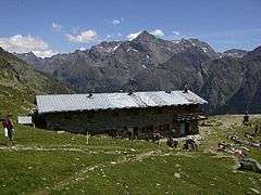
Refuge Crête Sèche or Rifugio Crête Sèche is a shelter in the Alps of Italy near the border with Switzerland. More precisely, this refuge is located in the valley of Valpelline, a side valley of the Aosta Valley in the Italian Pennine Alps, at 2,392 metres (7,848 ft) above sea level. It lies on the slopes of Mont de Crête Sèche whose summit is at elevation 2,941 metres (9,649 ft).[1]
The shelter was built in 1982, and is owned by the Italian Alpine Club. One of the nearby mountains to climb is Mont Gelé whose summit is 3,518 metres (11,542 ft) above sea level, and which can be accessed via the mountain pass called "Col de Crête Sèche" or "Colle di Crête Sèche". This same mountain pass continues from Italy into the Swiss district of Entremont in the canton of Valais. Another mountain near this shelter is Bec d'Epicoune, elevation 3,531 metres (11,585 ft).[1]
To reach the shelter, one can hike on a dirt trail for about two hours from the village of Ruz in the municipality of Bionaz.[2] The capacity of this shelter in summer is 90 beds, and in winter 8 beds.[1]
External links
- Official website (in English)
- Topographic map (showing "Ref. Crête Sèche" on map).
References
- 1 2 3 Waeber, Michael and Bauer, Marianne. Walliser Alpen: Gebietsführer für Wanderer, Bergsteiger, Skitourengeher und Kletterer ; die beliebtesten Anstiege auf alle wichtigen Gipfel mit Beschreibung aller empfehlenswerten, p. 466 (Bergverlag Rother GmbH, 2003). Mont de Crête Sèche is not to be confused with the mountain called Crête Sèche in Switzerland. The words "crête sèche" in French mean "dry ridge" in English.
- ↑ Ruz may also be referred to as Les Rus, Ru, or Rû.
Coordinates: 45°52′58″N 7°23′55″E / 45.88278°N 7.39861°E