Reno Stead Airport

| Reno Stead Airport | |||||||||||||||
|---|---|---|---|---|---|---|---|---|---|---|---|---|---|---|---|
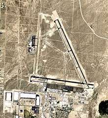 USGS 2006 orthophoto | |||||||||||||||
| IATA: none – ICAO: KRTS – FAA LID: RTS | |||||||||||||||
| Summary | |||||||||||||||
| Airport type | Public | ||||||||||||||
| Owner | Reno Tahoe Airport Authority | ||||||||||||||
| Serves | Reno, Nevada | ||||||||||||||
| Elevation AMSL | 5,050 ft / 1,539 m | ||||||||||||||
| Coordinates | 39°40′05″N 119°52′35″W / 39.66806°N 119.87639°WCoordinates: 39°40′05″N 119°52′35″W / 39.66806°N 119.87639°W | ||||||||||||||
| Website |
renoairport | ||||||||||||||
| Map | |||||||||||||||
 RTS Location of airport in Nevada | |||||||||||||||
| Runways | |||||||||||||||
| |||||||||||||||
| Statistics (2011) | |||||||||||||||
| |||||||||||||||
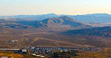
Reno/Stead Airport (ICAO: KRTS, FAA LID: RTS, formerly 4SD) is a large public and military general aviation airport located in the North Valleys area, 10 nautical miles (19 km) northwest of the central business district of Reno, in Washoe County, Nevada, United States.[1][2] A former military installation until 1966, when it was known as Stead Air Force Base, the airport's sole remaining military presence consists of an Army Aviation Support Facility and the 189th General Support Aviation Battalion of the Nevada Army National Guard, flying CH-47 Chinook helicopters.[3] The airport is owned by the Reno Tahoe Airport Authority.[1] The National Plan of Integrated Airport Systems for 2011–2015 categorized it as a general aviation reliever airport.[4]
Although most U.S. airports use the same three-letter location identifier for the FAA and IATA, this airport is assigned RTS by the FAA, but has no designation from the IATA (which assigned RTS to Rottnest Island Airport in Rottnest Island, Western Australia).[5]
Reno/Stead Airport does not have regularly scheduled service, but functions as a general aviation reliever for the nearby Reno/Tahoe International Airport. The airport is used by the Bureau of Land Management as a base for fire fighting aircraft.
In the late 1960s Reno Stead Airport was operated by the Ag Aviation Academy. Since 1964, it has been home to the National Championship Air Races, also known as the Reno Air Races, held every September. It was the launch site of "Earthwinds" balloon system in the early 1990s, which attempted and failed multiple times to circumnavigate the globe.
Facilities and aircraft
Reno/Stead Airport covers an area of 5,000 acres (2,023 ha) at an elevation of 5,050 feet (1,539 m) above mean sea level. It has two runways with asphalt surfaces: 14/32 is 9,000 by 150 feet (2,743 x 46 m) and 8/26 is 7,608 by 150 feet (2,319 x 46 m).[1]
For the 12-month period ending November 1, 2011, the airport had 71,000 aircraft operations, an average of 194 per day: 86% general aviation and 14% military. At that time there were 114 aircraft based at this airport: 75% single-engine, 11% military, 6% multi-engine, 6% jet, 1% glider, and 1% ultralight.[1]
See also
References
- 1 2 3 4 5 FAA Airport Master Record for RTS (Form 5010 PDF). Federal Aviation Administration. Effective November 15, 2012.
- ↑ "Reno-Stead Airport". Geographic Names Information System. United States Geological Survey. Retrieved May 3, 2009.
- ↑ "Aviation company formally reintegrates back into Nevada Army National Guard". Nevada Appeal. March 26, 2013.
- ↑ "2011–2015 NPIAS Report, Appendix A" (PDF, 2.03 MB). National Plan of Integrated Airport Systems. Federal Aviation Administration. October 4, 2010. External link in
|work=(help) - ↑ Great Circle Mapper: RTS / YRTI - Rottnest Island, Western Australia
External links
- Reno-Stead Airport page at Reno/Tahoe International Airport web site
- Reno Air Racing Association
- "Diagram of Reno/Stead Airport (4SD)" (PDF). from Nevada DOT
- Aerial image as of September 1999 from USGS The National Map
- FAA Terminal Procedures for RTS, effective December 8, 2016
- Resources for this airport:
- FAA airport information for RTS
- AirNav airport information for KRTS
- FlightAware airport information and live flight tracker
- NOAA/NWS latest weather observations
- SkyVector aeronautical chart, Terminal Procedures