Rensvik
| Rensvik | |
|---|---|
| Village | |
|
View of the village | |
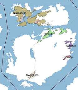 Location in Kristiansund | |
| Coordinates: 63°06′06″N 07°49′46″E / 63.10167°N 7.82944°ECoordinates: 63°06′06″N 07°49′46″E / 63.10167°N 7.82944°E | |
| Country | Norway |
| Region | Western Norway |
| County | Møre og Romsdal |
| District | Nordmøre |
| Municipality | Kristiansund Municipality |
| Area[1] | |
| • Total | 1.65 km2 (0.64 sq mi) |
| Elevation[2] | 20 m (70 ft) |
| Population (2013)[1] | |
| • Total | 2,501 |
| • Density | 1,516/km2 (3,930/sq mi) |
| Time zone | CET (UTC+01:00) |
| • Summer (DST) | CEST (UTC+02:00) |
| Post Code | 6521 Frei |

Rensvik is a village in Kristiansund Municipality in Møre og Romsdal county, Norway. The village is located on the northern part of the island of Frei, just west of the Omsund Bridge which connects to the island of Nordlandet to the north. The 1.65-square-kilometre (410-acre) village has a population (2013) of 2,501; which gives the village a population density of 1,516 inhabitants per square kilometre (3,930/sq mi).[1]
The village of Rensvik was the administrative center of the old Frei Municipality until 2008 when Frei was incorporated into Kristiansund Municipality.[3] The village of Kvalvåg lies about 5 kilometres (3.1 mi) to the southeast and the village of Nedre Frei is located about 8 kilometres (5.0 mi) to the south.
References
- 1 2 3 Statistisk sentralbyrå (1 January 2013). "Urban settlements. Population and area, by municipality.".
- ↑ "Rensvik" (in Norwegian). yr.no. Retrieved 2010-11-18.
- ↑ Store norske leksikon. "Rensvik" (in Norwegian). Retrieved 2010-11-27.
This article is issued from Wikipedia - version of the 7/9/2014. The text is available under the Creative Commons Attribution/Share Alike but additional terms may apply for the media files.