Rice Lake (Ontario)
| Rice Lake | |
|---|---|
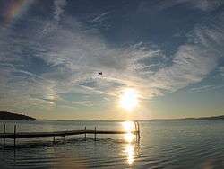 Sunset | |
| Location | Ontario |
| Group | south of Kawartha lakes (Ontario) |
| Coordinates | 44°11′N 78°10′W / 44.183°N 78.167°WCoordinates: 44°11′N 78°10′W / 44.183°N 78.167°W |
| Primary inflows | Otonabee River |
| Primary outflows | Trent River |
| Basin countries | Canada |
| Max. length | 32 km (20 mi) |
| Max. width | 5 km (3.1 mi) |
| Max. depth | 27 ft (8.2 m) |
| Surface elevation | 187 m (614 ft) |
| Islands | Cow |
| Settlements | Bewdley, Gores Landing, Hastings, Bailieboro, Roseneath |
Rice Lake is a lake located in south-eastern Ontario, in Northumberland County and Peterborough County. The lake is located south of the City of Peterborough and the Kawartha lakes (Ontario) and north of Cobourg and is part of the Trent-Severn Waterway, which flows into the lake by the Otonabee and out via the Trent. It is 32 km long and 5 km wide. Natives called it Pemadashdakota or "lake of the burning plains".
A drumlin field is located northwest of the lake, and the lake's islands are partially submerged drumlins. Rice Lake nearly bisects the Oak Ridges Moraine, with three wedges to the west (Albion, Uxbridge and Pontypool), and one wedge to the east (Rice Lake) which has terminus at the Trent River. A narrow corridor to the south of Rice Lake connects these wedges.
Rice Lake is fairly shallow and was named for the wild rice which grew in it and was harvested by native people of the area. Most of the extensive stands of wild rice originally found in here were wiped out when water levels were raised in the lake by the construction of the waterway.
The village of Bewdley sits on the west end of the lake and the town of Hastings sits on the east. Prehistoric burial mounds are found at Serpent Mounds Park on the north shore of the lake. Other places of interest include the Native Reserves of Alderville and Hiawatha. Other communities include Roseneath, Bailieboro, Gores Landing, Keene, Ontario and Harwood.
The Cobourg and Peterborough Railway was completed in 1854 and crossed Rice Lake from Harwood to Hiawatha. However, the thick layers of ice that cover the lake in the winter damaged the bridge beyond repair and it was declared unsafe and closed within six years. Sections of the railway bed are still clearly visible on the lake. In the late 19th century, steamboats provided passenger service.
Rice Lake is an attractive tourist area and is recognized for its recreational and sport fisheries. Rice Lake is said to be the lake with most fish in Ontario, which includes panfish, walleye, muskellunge and bass. In addition in recreational fishing an number of annual fishing contests are held here.
An annual charity poker run boat race starting from Bewdley is held the first Saturday after Labour Day, with proceeds going to the Children's Wish Foundation.
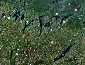
Islands on Rice Lake
Cow Island, Black Island, Foley Island (Upper and Lower), Grasshopper Island, Grape Island (East and West), Harmony Island, Harris Island, Hickory Island, Long Island, Margaret Island, Paudaush Island, Rack Island, Sheep Island, Spook Island, Sugar Island (East and West), Tic Island, and White's Island.
External links
| Wikimedia Commons has media related to Rice Lake (Ontario). |
- Fishing Rice Lake Ontario - Walleye, Smallmouth Bass, Largemouth Bass, Crappie, Perch, Panfish and Muskie
- Fishing on Rice Lake Walleye, Bass, Crappie, Perch, Panfish and Muskie