Kawartha Lakes (Ontario)

The Kawartha Lakes are a chain of lakes in south-central Ontario, Canada that form the upper watershed of the Trent River. The lakes are located on the boundary between the Paleozoic limestone regions of the Golden Horseshoe, and the Precambrian granite Canadian Shield of northern and central Ontario.
"Kawartha" is an anglicization of the word "Ka-wa-tha" (from "Ka-wa-tae-gum-maug" or Gaa-waategamaag), a word coined in 1895 by aboriginal Martha Whetung of the Curve Lake First Nations. It was hoped that the word, which meant "land of reflections" in the Anishinaabe language, would provide a convenient and popular advertising label for the area, much as "Muskoka" had come to describe the area and lakes north of Gravenhurst. The word was subsequently changed by tourism promoters to Kawartha, with the meaning "bright waters and happy lands."[1]
Though the city of Kawartha Lakes is named for them, more than half of the Kawartha Lakes are in fact located in Peterborough County. The Trent-Severn Waterway makes its way through many lakes in the main chain; many cottages dot the lakes' shorelines some of which are quite large in size, and the region is most known for its recreational tourism.
Primary chain
Lakes considered to be among 'The Kawarthas' include:
- Trent River
- Talbot River
- Canal Lake
- Mitchell Lake
- Talbot Lake
- Severn River
- Lake Dalrymple
- Cranberry Lake
- Head Lake
- Fishog Lake
Some additional lakes include:
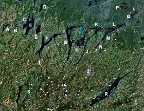
- Buckhorn Lake (H)
- Lake Chemong (J)
- Lower Buckhorn Lake (K)
- Lovesick Lake (Between K & L)
- Stony Lake (L)
- Lake Scugog (S) is to the southwest of the main chain.
Some additional lakes are sometimes included, but are not part of the Kawartha Lakes:
- Clear Lake (M)
- White/Dummer Lake
- Katchewanooka Lake (N)
- Rice Lake (R)
- Salerno Lake
- Jack Lake (P)
Kawartha Highlands
A system of interconnected lakes lies to the north of the main chain. Due to an artificial dam placed at the south end of Mississauga lake in the mid-20th century, these lakes have equal levels and are inter-navigable. They consist of Catchacoma Lake, Beaver Lake, Mississauga Lake, Gold Lake, McGinnis Lake, Cold Lake, and Cavendish Lake.
Also nearby, but not reachable by boat without portage, are Gull Lake, Anstruther Lake, Bottle Lake, and Sucker Lake. The area is partially enclosed by Kawartha Highlands Provincial Park.
References
- ↑ Rayburn, Alan (1997). Place names of Ontario. Toronto, Buffalo: University of Toronto Press. p. 176. ISBN 978-0-8020-0602-8. OCLC 36342881.
Coordinates: 44°29′57.84″N 78°26′27.60″W / 44.4994000°N 78.4410000°W
City of Kawartha Lakes | |||||||||||
|---|---|---|---|---|---|---|---|---|---|---|---|
| Towns | 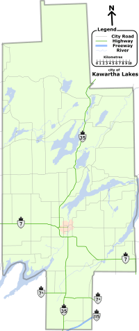 | ||||||||||
| Villages and unincorporated communities |
| ||||||||||
| Former townships | |||||||||||
| Major lakes |
| ||||||||||
| Topics | |||||||||||
1) This area lies on the border of an adjacent region, but is part of the Kawartha Lakes census. | |||||||||||