Riesa-Großenhain
| Riesa-Großenhain | |
|---|---|
| District | |
 | |
| Country |
|
| State | Saxony |
| Adm. region | Dresden |
| Disbanded | 2008-08-01 |
| Capital | Großenhain |
| Area | |
| • Total | 820.51 km2 (316.80 sq mi) |
| Population (2001) | |
| • Total | 120,539 |
| • Density | 150/km2 (380/sq mi) |
| Time zone | CET (UTC+1) |
| • Summer (DST) | CEST (UTC+2) |
| Vehicle registration | RG |
| Website | http://www.riesa-grossenhain.de |
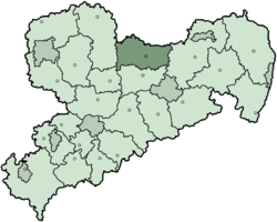
Riesa-Großenhain was a district in the Free State of Saxony, Germany. It was bounded by (from the north and clockwise) the districts of Elbe-Elster and Oberspreewald-Lausitz in Brandenburg, Kamenz, Meißen, Döbeln and Torgau-Oschatz.
History
The district was created in 1994 by merging the two previous districts Riesa and Großenhain. In August 2008, it was incorporated into the district of Meißen.
Geography
The district is situated in the plain countryside north of the virtual line connecting Leipzig and Dresden. The main river is the Elbe which runs through the district from south to northwest.
Coat of arms
 |
The linden branch in the left of the coat of arms symbolizes the nature in the district, and is also a symbol for Riesa as it was present in the coat of arms of Riesa since 1623. The black lion on yellow ground stands for Großenhain, as it is also present in then coat of arms of the city Großenhain. The cogwheel in the bottom symbolizes the industrial tradition of the district, mostly iron and steel production, engineering and textile production. |
Towns and municipalities
| Towns | Municipalities | |
|---|---|---|
External links
- Official website (German)
| Urban districts | |
|---|---|
| Rural districts | |
| Former urban districts | |
| Former rural districts | |
Towns and municipalities in Riesa-Großenhain | ||
|---|---|---|
Coordinates: 51°17′N 13°33′E / 51.283°N 13.550°E
This article is issued from Wikipedia - version of the 5/19/2015. The text is available under the Creative Commons Attribution/Share Alike but additional terms may apply for the media files.