Rigi
| Rigi | |
|---|---|
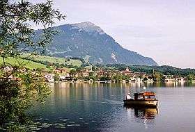 Rigi behind Lake Lauerz | |
| Highest point | |
| Peak | Rigi Kulm |
| Elevation | 1,797.5 m (5,897 ft) [1] |
| Prominence | 1,290 m (4,230 ft) [1] |
| Isolation | 13.1 km (8.1 mi) [2] |
| Coordinates | 47°03′24″N 8°29′08″E / 47.05667°N 8.48556°ECoordinates: 47°03′24″N 8°29′08″E / 47.05667°N 8.48556°E |
| Geography | |
 Rigi Location in Switzerland | |
| Country | Switzerland |
| Canton | Schwyz and Lucerne |
| Parent range | Schwyzer Alps |
| Topo map | Swiss Federal Office of Topography swisstopo |
| Climbing | |
| Easiest route | Train and Cable-car |
The Rigi (or Mount Rigi; also known as Queen of the Mountains) is a mountain massif of the Alps, located in Central Switzerland. The whole massif is almost entirely surrounded by the water of three different water bodies: Lake Lucerne, Lake Zug and Lake Lauerz. The range is in the Schwyzer Alps, and is split between the cantons of Schwyz and Lucerne, although the main summit, named Rigi Kulm, at 1,798 meters above sea level, lies within the canton of Schwyz.
The Rigi Kulm and other areas, such as the resort of Rigi Kaltbad, are served by Europe's oldest mountain railways, the Rigi Railways. The whole area offers many activities such as skiing or sledging in the winter, and hiking in the summer.
Peaks
| Name of peak | Height above sea (in meter) | Canton |
|---|---|---|
| Rigi Kulm | 1,797.5 m (5,897 ft) | SZ |
| Rotstock | 1,658 m (5,440 ft) | LU/SZ border |
| Dosse | 1,684 m (5,525 ft) | LU/SZ border |
| Scheidegg | 1,658 m (5,440 ft) | SZ |
| Vitznauerstock (LU)/Gersauerstock (SZ) | 1,452 m (4,764 ft) | LU/SZ border |
| Rigi Hochflue (Urmiberg) | 1,698 m (5,571 ft) | SZ |
Etymology
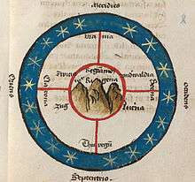
The name Rigi is from Old High German *rigî, from rîga "row, stripe, furrow", after the stratification that is clearly visible on the north-side of the mountain. The name is first recorded in 1350 as Riginun.
The name was interpreted as Regina montium "queen of mountains" by Albrecht von Bonstetten (1479), who however gives Rigena as alterative form.[3]
Bonstetten's interpretation as Regina was influential in the 17th century, and was still repeated in 18th-century travelogues. Karl Zay (Goldau und seine Gegend, 1807) criticized this latinization, arguing for mons rigidus instead. Later in the 19th century, many authors repeated either rigidus or regina as the name's supposed origin. The two possibilities were also adduced as explanation the name's grammatical gender alternating between masculine and feminine.[4] Brandstetter (Die Rigi, 1914) finally discredited these interpretations and established the origin in Old High German rîga (whence modern German Reihe, Reigen; cognate with English row).
Transport
There are multiple public transport options available to ascend Mt. Rigi:
- By rack railway from Arth-Goldau and Vitznau, operated by the Rigi-Bahnen. The Vitznau-Rigi-Bahn started operation on May 21, 1871 and was the first mountain railway in Europe. On June 4, 1875 the Arth-Rigi-Bahn was finished, allowing access from the other side of the mountain. They were electrified in 1937 and 1907 respectively, with the Arth-Rigi-Bahn becoming the first electrified standard gauge rack-railway in the world. Both lines go all the way to the summit, Rigi Kulm.
- By gondola lift from Weggis to Rigi-Kaltbad.
- By cable-car from the Kräbel station on the Arth-Rigi-Bahn line to Rigi-Scheidegg.
Recreation
Mt. Rigi offers an area for recreation and sports measuring approximately 90 square kilometres (35 sq mi) offering a variety of well-maintained walking trails or mountain hikes where visitors can have a panoramic view of 150 km (93 mi) from various marked points. There are also numerous public grilling stations located near the hiking trails.
Rigi is also a perfect destination for people practising winter sports and other winter recreation activities.
Mt. Rigi in culture
Mt. Rigi has been featured in many works of art, including both paintings and literary publications. Perhaps the most famous paintings of the Rigi were a series by JMW Turner, including The Blue Rigi, Sunrise, several of which are in the collection of the Tate Britain art gallery in London.[5]
Mark Twain also visited Rigi during his tour of Central Europe in the late 1870s, and wrote about his travels in chapter 28 of his "A Tramp Abroad."
There is a Catskills resort called the Rigi Kulm in Abraham Cahan's novel The Rise of David Levinsky (1917).
The Rigi, a downhill road in Wellington, New Zealand, is named for the mountain and for many years was used as a main thoroughfare for coach riders.[6]
Geology
Technically, the Rigi is not a part of the Alps, and belongs instead to the Swiss plateau. It is mostly composed of molasse and other conglomerate, as opposed to the Bündner schist and flysch of the Alps.
See also
- List of mountains of the canton of Schwyz
- List of mountains of Switzerland
- List of most isolated mountains of Switzerland
- List of mountains of Switzerland accessible by public transport
References
- 1 2 Swisstopo maps
- ↑ Retrieved from Google Earth. The nearest point of higher elevation is north of the Buochserhorn.
- ↑ "Und ist das der berg Rigena, die die alten ein küngin der bergen geheyssen habent. Dann in dem selbigen berg sint vor langen, alten ziten heiligen verborgen gelegen, die noch zuͦ disen ziten (als man redt) mit himelscher sinphonie und lobgesang oft gehöret werden got lobent, und ir liplichen fuͦsstritten oft gloubhaftigen lüten erschinen sind." "Superioris Germanie Confoederatis descriptio" / "... der Obertütscheit Eidgnosschaft ... kurze beschribung" ed. Albert Büchi, QSG 13 (1893), 217-267.
- ↑ "Die Wurzelwort-Forscher und Urkunden-Leute haben schon gelehrte Untersuchungen angestellt, ob der Name 'Rigi' von rigidus mons (der rauhe Berg) oder von regina montium (die Königin der Berge) abstamme und er somit ein Masculinum oder Femininum sei; jede Vermuthung hat gleich Viel für sich." (Berlepsch, Hermann, Alexander): Der Rigi, der Vierwaldstätter-See und die Urkantone. Ein Führer für Fremde. Leipzig 1858.
- ↑ "The Blue Rigi, Sunrise, Joseph Mallord William Turner". Tate, London. Retrieved 2013-01-06.
- ↑ Joseph Romanos (2013-03-22). "When The Rigi was the main coach road". The Dominion Post.
External links
| Wikimedia Commons has media related to Rigi. |
Gallery
 Steam train
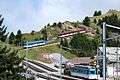 Station near the summit
 View from summit
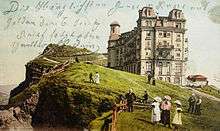
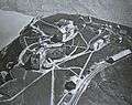 Rigi Kulm 1920
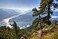 Lake Lucerne seen from Rigi
 Turner - The Blue Rigi- Lake of Lucerne - Sunrise (1842)
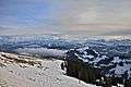 View of the alps of central Switzerland from Rigi Kulm.