Scheidegg (Rigi)
| Scheidegg | |
|---|---|
| Rigi Scheidegg (cable car station) | |
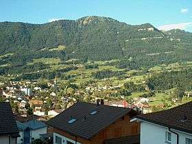 View from Goldau | |
| Highest point | |
| Elevation | 1,658 m (5,440 ft) [1][2] |
| Prominence | 113 m (371 ft) [3] |
| Parent peak | Dosse |
| Coordinates | 47°01′39″N 08°31′12″E / 47.02750°N 8.52000°ECoordinates: 47°01′39″N 08°31′12″E / 47.02750°N 8.52000°E [2] |
| Geography | |
 Scheidegg Location in Switzerland | |
| Country | Switzerland |
| Canton | Schwyz |
| Parent range | Schwyzer Alps |
| Topo map | Swiss Federal Office of Topography swisstopo |
The Scheidegg (1,658 m or 5,440 ft) is a mountain summit of the Rigi massif, overlooking Goldau in the canton of Schwyz on its north mountainside, and Gersau and the Gersauerbecken on its south side. The cable car station 160 metres east of it is called Rigi Scheidegg.[1][2]
The summit is connected by two cable cars, one, the Luftseilbahn Kräbel–Rigi Scheidegg (LKRS), on the north side connecting to the Kräbel station on the Arth-Rigi Bahn (ARB), and another one, the Luftseilbahn Obergschwend–Rigi Burggeist (LORB), on the south side leading down to Obergschwend in the municipality of Gersau. Alternatively it is possible to walk from Scheidegg to Rigi Kaltbad or Rigi Klösterli by a panoramic footpath on the eastern and western mountainside of the Rigi massif. Much of the path uses the trackbed of the former Rigi–Scheidegg railway that once linked Kaltbad and Scheidegg.[4]
The summit of Scheidegg was once the site of a large hotel, built in 1830. The reduction in tourism due to World War I, and the subsequent change in tourism from overnight stays to day trips, resulted in the closure of the hotel and its eventual demolition in 1943/4.[5]
 Scheidegg in the 1890s, showing the hotel that once occupied the peak.
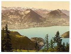 View from Scheidegg in the 1890s, looking towards the Oberland Alps.
See also
References
- 1 2 No. 1151 Rigi (Map) (2016 ed.). 1:25000. National Map 1:25 000. Berne, Switzerland: Swiss Federal Office of Topography – swisstopo. 2013. ISBN 978-3-302-01151-6. Retrieved 2016-10-04.
- 1 2 3 Scheidegg (Rigi) (Map) (2016 ed.). 1:10 000. Landeskarte 1:10'000 (farbig) (Bundesamt für Landestopografie swisstopo). Berne, Switzerland: Swiss Federal Office of Topography – swisstopo. 28 February 2016. Retrieved 2016-10-04.
- ↑ Retrieved from the Swisstopo topographic maps. The key col is the Hinder Dosse (1,545 m).
- ↑ "Rigi Panorama Trail". rigi.ch. RigiPlus AG/Rigi Bahnen AG. Archived from the original on 2016-10-06. Retrieved 2016-10-06.
- ↑ "Rigi". Historical Dictionary of Switzerland (in German). 2012-01-03. Retrieved 2016-10-05.
External links
 Media related to Scheidegg at Wikimedia Commons
- Rigi Scheidegg on Hikr