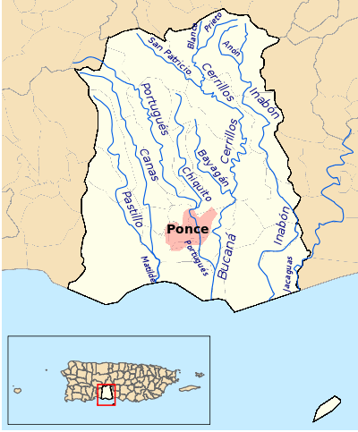
Portugués River
Coordinates: 17°59′31.488″N 66°35′51.2874″W / 17.99208000°N 66.597579833°W
| Portugués River | |
|---|---|
|
Portugues River in Ponce, Puerto Rico, looking north from Puente de los Leones at Miguel Pou Boulevard (PR-1) | |
| Country | Puerto Rico |
| Basin | |
| Main source |
Barrio Portugues, Adjuntas, Puerto Rico 2,853 feet (870 m)[1] |
| River mouth |
Bucaná River 3 feet (0.91 m)[2] |
| Progression |
Guaraguao San Patricio Tibes Portugués Machuelo Arriba Sexto Quinto Tercero Cuarto San Antón Bucaná |
| River system | Río Bucaná |
| Basin size | 20.33 sq mi (52.7 km2)[3] |
| Physical characteristics | |
| Length | 18.43 miles (29.66 km)[4] |
| Discharge |
|
| Features | |
| Tributaries |
|

Portugués River (Spanish: Río Portugués) is a river in the municipality of Ponce, Puerto Rico. The river is also known as Río Tibes in the area where it flows through barrio Tibes in the municipality of Ponce.[6] Río Portugués has a length of nearly 30 kilometers (19 mi) and runs south from the Cordillera Central mountain range into the Caribbean Sea. The Portugués is one of the best-known rivers in Ponce because of its prominent zigzagging through the city and its historical significance.[7] The river is historically significant because the city of Ponce had its origins on its banks. It was originally known as Río Baramaya (Baramaya River).[8] The river has its mouth at 17°58′51″N 66°37′26″W / 17.98083°N 66.62389°W. This river is one of the 14 rivers in the municipality. At one point it was also known as Río Ponce.[9]
Origin
Portugués River has its origin in Cerro Guilarte,[10] located the western part of barrio Portugués in the bordering municipality of Adjuntas,[11] just north of Ponce, and drains into the Caribbean Sea after running for some 27.6 kilometers (17.1 mi).[12][note 1] The river has a discharge of 16,000 feet3/second.[13] The toponomy, or origin of the name, comes from one of its first settlers, Pedro Rodríguez de Guzman, knows as el Portugués ("the Portuguese") because his ancestry was from Portugal.[14][note 2]
Tributaries
Río Chiquito is one of the tributaries of Río Portugués (i.e., Río Chiquito feeds into Río Portugués).[15] In the sectors and sub-barrios that it traverses, the locals call the river by the name of such sector/barrio. Thus names such as Río Cedro, Río Nuez, Río Moscada, and Río Tibes as the unofficial local name of Río Portugués in the sectors known as Cedro, Nuez, Moscada and Tibes.[16]
Course of the river
Starting at its origin in Barrio Portugués, Adjuntas, Portugués River, as it is known locally, begins to form at an altitude of approximately 2,853 feet (870 m) above sea level.[17] The river then runs in a southerly direction parallel to PR-10 for most of its trajectory, crossing barrios Guaraguao, San Patricio, and Tibes. It brushes barrio Machuelo Arriba on its southwestern corner after it crosses PR-10 just west of the intersection of PR-10 and PR-504, immediately north of the Ponce city limits. From there it enters barrio Machuelo Abajo and continues south crossing Avenida Betances/Avenida Tito Castro (PR-14), at a point about half a mile west of the intersection of routes PR-12 and PR-14. A few hundred feet before the Avenida Betances bridge over Río Portugués in the city of Ponce, the river divides barrios Sexto, located west of the river, and Machuelo Abajo, to the east. It continues south crossing Calle Guadalupe, at which point it divides barrio Quinto to the west and Machuelo Abajo to the east. This point is just west of Club Deportivo de Ponce. Several hundred feet further downstream, at Miguel Pou Boulevard–PR-1 and Puentes de los Leones–Tricentennial Park, the river divides barrios Tercero and San Antón. Further downstream, the river runs immediately west of La Ceiba Park on Calle Comercio (route PR-133) in sector Cuatro Calles. After crossing Calle Comercio, Río Portugués divides barrios Cuarto and San Anton, and continues its southerly course towards Avenida Las Americas (PR-163).
Former and current course
For flood control purposes, Río Portugués was diverted in the 1970s by the U.S. Corps of Engineers from emptying directly into the Caribbean Sea at Playa de Ponce to feeding into the Río Bucaná which then empties into the Caribbean Sea. This canalization project was completed in 1997.[18]
Former course
The former course of Río Portugués, prior to being diverted and canalized by the U.S. Corps of Engineers in the 1970s, followed from the area just north of Avenida Las Americas/PR-163 in a south-southwesterly fashion crossing Avenida Las Americas immediately east of Hospital Dr. Pila. It then continued south behind the Governmental Center/Puerto Rico Police Ponce Area headquarters, and followed a trajectory almost parallel to Avenida Hostos (PR-123, formerly PR-10). It then crossed PR-2 immediately east of the intersection of Avenida Hostos and Ponce Bypass/PR-2, at the sector called "Caracoles". From there the river used to continue flowing southerly, at one point just edging the area where Plaza del Caribe now stands. This old course then took a sharp westerly turn and crossed Avenida Hostos, at the now historic Puente Río Portugués. From this point it continued running south-southwesternly where it (now, since the newly built PR-52) crossed PR-52. From here the river flowed another one mile (1.6 km) crossing the low-lying area of Barrio La Playa at Avenida Padre Noel before draining into the Caribbean Sea about 30 or 40 yards from Avenida Padre Noel, in the area called Villa Pesquera.
Current course

Once the U.S. Corps of Engineers canalized Río Portugués as it flowed through the city of Ponce, the Corps also diverted its course from a south-southwesterly course to a south-southeasterly course. This diversion started immediately south of the river's intersection with Avenida Las Americas.
From Avenida Las Americas the river now flows, canalized, in a south-southeasterly after crossing Avenida Las Americas about a quarter of a mile east of Hospital Dr. Pila. After crossing Avenida Las Americas in downtown Ponce, the river comes to the location where in the 1970s it was diverted by the US Corps of Engineers from a southwesterly path to its current southeasterly path. Taking a sharp easterly turn, Río Portugués enters barrio San Antón, and crosses route PR-12/Avenida Malecon about one quarter of a mile north of PR-12's intersection with PR-2. Shortly thereafter the river bends to become southbound and crosses route PR-2, about one quarter of a mile east of PR-2's intersection with PR-12. The river then borders the Julio Enrique Monagas Family Park on the park's western edge until, still canalized, it feeds into Bucaná River about half a mile south of PR-2. The point where Río Portugués feeds into Río Bucaná is about one quarter of a mile north of PR-52 (a.k.a., Autopista Luis A. Ferre) and can be seen from the southbound side of PR-52.
Bucaná River
After this point Portugués River is no longer called Río Portugués. It becomes Río Bucaná (Bucaná River) and divides barrios Playa on its western bank and barrio Bucaná on its eastern bank. From there the river continues flowing in southerly course as a single canalized river for half-mile, crossing Autopista Luis A. Ferre/PR-52. Another one mile (1.6 km) of southerly flow and the river empties as a single stream into the Caribbean Sea just east of La Guancha, safely avoiding most low-laying populated areas.[19]
Uses
Today Río Portugués is one of the most popular rivers for swimming in southern Puerto Rico.[20]
Portugués Dam
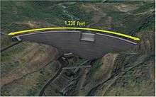
In 1986, the U.S. Congress approved funding to build the Portugués Dam for Portugués River about 4 miles (6.4 km) northwest of Ponce. Construction began in April 2008[21] and, when finished, the dam will be the first roller-compacted concrete thick arch dam built anywhere in U.S. soil by the U.S. Army Corps of Engineers.[22][23] The Cerrillos Dam over Río Cerrillos was finished in 1992, and had also been approved by Congress in 1986. The cost to build the Portugués Dam is over $192 million.[24]
The dam will consist of a dike of 220 feet high by 1,230 feet wide. It will use 368,000 cubic yards of compressed concrete. As of 22 March 2009, 88 percent of the concrete work had been completed. Its scheduled completion date is 2013. The total investment is $375 million USD.[25]
Preservation
In 1971, Mr. and Mrs. Clark Foreman, owners of the Adjuntas property where the Portugués River originates, granted the development rights of their property in Adjuntas to the Conservation Trust of Puerto Rico, thereby establishing the first scenic and conservation easement in Puerto Rico. The deed of easement and its restrictive covenants protect a 40-acre (160,000 m2) tract of land that includes the headwaters of Río Portugués. Although the title to the land remains with the Foreman family, the easement restricts the use of the land, safeguarding its trees, vegetation, and other natural resources against destruction or alteration in perpetuity. Today, 42 acres (170,000 m2) of Río Portugués scenic easement in Adjuntas's humid forest are a protected entity of the Conservation Trust of Puerto Rico.[26]
See also
Notes
- ↑ Other sources report lengths of 18.4 miles - 29.6 km - (See, for example, HERE, Los Rios. Hojas de Nuestro Ambiente. February 2007: P013. Page 3. Puerto Rico Department of Natural and Environmental Resources. Retrieved 27 November 2013.) and 16.1 miles - 25.9 km - (See, for example, HERE, Informe Ecologico de Flora y Fauna, Proyecto Gasoducto del Sur: Peñuelas, Ponce, Juana Díaz, Santa Isabel, Salinas. For: Proyecto Gasoducto del Sur - Peñuelas, Ponce, Juana Díaz, Santa Isabel, Salinas. By: ENSR (Piscatway, NJ) - AEE (Autoridad de Energia Electrica). Page 19. Retrieved 26 November 2013.)
- ↑ Another source names this early settler "Pedro Perdomo de Guzmán". It is not clear which of the two names is the correct name, or if his name was perhaps Pedro Rodriguez Perdomo de Guzmán or some other variation. See Historia de Nuestros Barrios: Portugués, Ponce. Rafael Torrech San Inocencio. El Sur a la Vista. Ponce, Puerto Rico. Elsuralavista.com. 14 February 2010.
References
- ↑ Rios mas importantes de Puerto Rico. PRFrogui.
- ↑ Maptest. Government of the Commonwealth of Puerto Rico. General Purpose Population Data, Census 2000. Unidad de Sistemas de Información Geográfica, Área de Tecnología de Información Gubernamental, Oficina de Gerencia y Presupuesto. Gobierno de Puerto Rico. Retrieved 24 October 2011.
- ↑ Los Rios. Hojas de Nuestro Ambiente. February 2007: P013. Page 3. Puerto Rico Department of Natural and Environmental Resources. Retrieved 30 October 2011.
- ↑ Los Rios. Hojas de Nuestro Ambiente. February 2007: P013. Page 3. Puerto Rico Department of Natural and Environmental Resources. Retrieved 30 October 2011.
- ↑ Ferdinand Quiñones and Karl G. Johnson. The Floods of May 17–18, 1985 and October 6–7, 1985 in Puerto Rico. U.S. Geological Survey. Open File Report 87-123. Prepared in Conjunction with the Puerto Rico Department of Natural Resources, Puerto Rico Environmental Quality Board, and the Puerto Rico Highway Authority. San Juan, Puerto Rico. 1987. Page 15.
- ↑ Government of the Autonomous Municipality of Ponce. Recursos Naturales. Ponce Ciudad Señorial. Retrieved 21 November 2011.
- ↑ Sunny A. Cabrera Salcedo. Hacia un Estudio Integral de la Toponimia del Municipio de Ponce, Puerto Rico. Ph. D. dissertation. May 1999. University of Massachusetts Amherst. Graduate School. Department of Spanish and Portuguese. Page 49.
- ↑ Ponce, Puerto Rico. Arecibo Web. Retrieved January 18, 2010.
- ↑ Government of the Municipality of Ponce. Periodico "El Señorial". Special issue: Carnaval Ponceño 2013. February 2013. Page 17. Ponce, Puerto Rico.
- ↑ Las Fiestas Populares de Ponce y La Villa de Ponce. Ramon Marin. 1875. Ponce, Puerto Rico: Imprenta El Vapor. 72 pages. (Reprinted September 1994. San Juan, Puerto Rico: Editorial de la Universidad de Puerto Rico. 281 pages. Page 187.) Retrieved 23 July 2012.
- ↑ Los ríos y embalses de Adjuntas. Obed David Cintrón González.
- ↑ Río Portugués. PRFrogui.
- ↑ Ferdinand Quiñones and Karl G. Johnson. The Floods of May 17–18, 1985 and October 6–7, 1985 in Puerto Rico. U.S. Geological Survey. Open File Report 87-123. Prepared in Conjunction with the Puerto Rico Department of Natural Resources, Puerto Rico Environmental Quality Board, and the Puerto Rico Highway Authority. San Juan, Puerto Rico. 1987. Page 8.
- ↑ Government of the Municipality of Ponce. Periodico "El Señorial". Special issue: Carnaval Ponceño 2013. February 2013. Page 17. Ponce, Puerto Rico.
- ↑ Estudios Sociales. Ponce, Puerto Rico: Hidrografia. Projecto Salon Hogar. Retrieved August 8, 2009.
- ↑ Ponce, Puerto Rico. Jorge A. Figueroa Irizarry, Director. Ponce History Museum. Released by Professor F. Suarez. Pontificial Catholic University of Puerto Rico. Page 25.
- ↑ PRFROFUI. RÍOS MAS IMPORTANTES DE PUERTO RICO.
- ↑ Proyecto de año: Represa Portugues, Construccion con Ingenieria Extrema. Planos y Capacets. May-Jun 2011. Page 10. Retrieved 28 September 2012.
- ↑ Surface-Water, Water-Quality, and Ground Water Assessment of the Municipio of Ponce, Puerto Rico, 2002-2004. Jesús Rodríguez-Martínez, Luis Santiago-Rivera, José M. Rodríguez, and Fernando Gómez-Gómez. Scientific Investigations Report No. 2005-5243. United States Geological Survey. Page 81.
- ↑ Recreación para todos sin salir de Ponce. Sandra Torres Guzmán. La Perla del Sur. Ponce, Puerto Rico. 18 June 2014. Page 26. Retrieved 18 June 2014.
- ↑ Gobernador resalta su gestión en el Sur. Jason Rodríguez Grafal. La Perla del Sur. Ponce, Puerto Rico. 2 November 2011. Retrieved 2 November 2011.
- ↑ Dam over Portugués River Retrieved November 1, 2009.
- ↑ Portugues Dam. Oficinas Comerciales. Spain.
- ↑ Gobernador resalta su gestión en el Sur. Jason Rodríguez Grafal. La Perla del Sur. Ponce, Puerto Rico. 2 November 2011. Retrieved 2 November 2011.
- ↑ No se detiene la Represa Portugués. Jason Rodríguez Grafal. La Perla del Sur. Ponce, Puerto Rico. Retrieved 4 November 2011.
- ↑ Hacienda Buena Vista. Río Portugués. Fideicomisio de Puerto Rico.
External links
- Portugues River during the rainy season Retrieved January 5, 2011.
- Portugues River in Barrio Playa, before its course was changed to empty by Barrio Bucana. Retrieved January 5, 2011.