Playa (Ponce)
| Barrio Playa | |
|---|---|
|
La Guancha Boardwalk, one of the landmarks in Barrio Playa | |
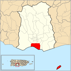 Location of barrio Playa within the municipality of Ponce shown in red | |
| Country |
|
| Territory |
|
| Municipality |
|
| Area | |
| • Total | 14.98 sq mi (38.8 km2) |
| • Land | 4.38 sq mi (11.3 km2) |
| • Water | 10.60 sq mi (27.5 km2) |
| Population (2000) | |
| • Total | 16,926 |
| • Density | 3,864/sq mi (1,492/km2) |
| Source: 2000 Census | |

Barrio Playa, also known as Playa de Ponce, Ponce Playa, or La Playa, is one of the thirty-one barrios that comprise the municipality of Ponce, Puerto Rico. Along with Bucaná, Canas, Vayas, and Capitanejo, Playa is one of the municipality's five coastal barrios. Barrio Playa also incorporates several islands, the largest of which is Caja de Muertos.[1] It was founded in 1831.[2]
Location
Playa is an urban barrio located in the southern region of the municipality, within the limits of the city of Ponce, south of the traditional center of the city at Plaza Las Delicias, and on the shores of the Caribbean Sea. It is located at 17.9839°N 66.6128°W, and it has an elevation of 10 feet.[3] The toponomy, or origin of the name, describes the geographic area the barrio occupies in southern Ponce and facing the Caribbean Sea.[4]
Boundaries
It is bounded on the North by PR-2, on the South by the Caribbean Sea, on the West by Río Matilde, and on the East by Río Bucaná.[5][6]
In terms of barrio-to-barrio boundaries, Playa is bounded in the North by Canas Urbano and San Anton, in the South by the Caribbean Sea, in the West by Canas, and in the East by Bucaná.[7]
Features and demographics
Unlike most other barrios of Ponce, Playa's landscape is entirely flat. Playa also has the second longest coastline of all five of Ponce's coastal barrios, after Canas. Playa has 4.6 square miles (12 km2) of land area and no water area.[8]
In 2000, the population of Playa was 4,761 persons, and it had a density of 1,031 persons per square mile.[8] The communities of Villa del Carmen, Valle Real, Villa Tabaiba, Salistral, El Caribe, Puerto Viejo, Los Meros, Amalia Marin, Lirios del Sur, and Playa proper are found here.[6][9]
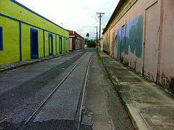
This barrio, or ward, has its own plaza giving it the character of a municipality within a municipality. It has a residential area, a tourist area called La Guancha, and a harbor, Puerto de Ponce.
Playa has the second longest coastline of all five coastal barrios in Ponce, after Canas.[10]
History
As the major means of external communication for the settlement that was to become the city of Ponce, barrio Playa has a history that is as old as the history of the city of Ponce itself, thus dating back to the 16th century. Subsequently, during the 17th and 18th centuries, significant contraband took place on these shores as well as attempts to attack and ransack the Playa settlement. A lookout post was set up in El Vigia to warn the city of the need of help in the Playa harbor, a port settlement at the time.
By the 1830s, la Playa had one of the best roads in Puerto Rico, connecting the shore settlement to the city proper, and it was the center of Ponce's commercial activity. It subsequently also got the first phone lines in Ponce and was also the first one to get railroad service from downtown Ponce.[11]
Unfortunately, in 1845 a significant fire occurred in La Playa.[12] The fire destroyed Playa and most of the Ponce vicinity. It significantly damaged the Spanish Customs House in Ponce, this being one of the few building left standing after the fire.[13] The fire burned down the major buildings of the "Marina de Ponce".[12] This moved Puerto Rico governor Conde de Marisol to create a new voluntary fire-fighting organization island-wide.
In 1887 the Spanish government built a lighthouse at Caja de Muertos Light on an island by the same name just off the coast of barrio Playa.[14] This was followed by the building of Cayo Cardona lighthouse in 1889, on a small island at the entrance of the Ponce harbor.[15] Both of these islands are part of barrio Playa.
By 1913, Playa was "a dynamic neighborhood with a self-substained urban development with a population of 5,169 distributed through a residential area dominated by wooden houses, sugar cane farms, churches, schools, hospitals, a cemetery and local indiustries that promoted the formation of a strong artisan and industrial workers class."[11] Playa is considered Puerto Rico's first planned suburban area.[16]
In 1929, La Playa was the place where Dr. Manuel de la Pila Iglesias worked for the U.S. federal government with such distinction as to earn him the title "physician of physicians."[17]
Today, Playa is a mostly low-income barrio of Ponce, and thus this is where Isolina Ferré founded her "Centro de Orientacion de la Playa" hospital and school that would earn her the U.S. Presidential Medal of Freedom in 1999. The Ponce Playa Diagnostic and Treatment Center was also founded in barrio Playa de Ponce.
Landmarks
Playa is home to a mix of Ponce and Puerto Rico landmarks: Puerto Rico Iron Works foundry, Plaza del Caribe mall, Club Náutico de Ponce yacht club, La Guancha boardwalk, and Coffin Island natural reserve are all located in Barrio Playa. The historic Cardona Island Light, Caja de Muertos Lighthouse, United States Custom House and McCabe Memorial Church,[18] all National Register of Historic Places listed landmarks, are also located in Barrio Playa. Playa also has the most important Caribbean seaport in Puerto Rico, called Port of the Americas.[19]
Notable natives and residents
People from La Playa are called "playeros".
- Rafael Cordero Santiago, mayor of Ponce (1988–2004)
- Javier Culson, Olympic medal winner track-and-field athlete
- Carmen Nydia Velázquez, comedian and singer
- Jaime L. Drew, educator, writer, civil servant and engineer
Coordinates: 17°58′56″N 66°37′20″W / 17.98224°N 66.62212°W[20]
References
- ↑ Map of Ponce Municipio, Puerto Rico. United States Geological Survey. Home Town Locator. Retrieved 6 June 2011.
- ↑ Barrios de Ponce. Antepasados Esclavos.(From: Pedro Tomás de Córdoba. Memorias geográficas, históricas, económicas y estadísticas de la Isla de Puerto Rico.) Retrieved 28 November 2014.
- ↑ U.S. Geological Survey. Topographic Map of Ponce. Map Styles: Map and Shaded. Trails.com. From: USGS. Topo Map. Projection: NAD83/WGS84. Coordinates and Elevation of Barrio Playa. Retrieved February 25, 2010.
- ↑ Government of the Municipality of Ponce. Periodico "El Señorial". Special issue: Carnaval Ponceño 2013. February 2013. Page 17. Ponce, Puerto Rico.
- ↑ Government of the Commonwealth of Puerto Rico. General Purpose Population Data, Census 2000. Unidad de Sistemas de Información Geográfica, Área de Tecnología de Información Gubernamental, Oficina de Gerencia y Presupuesto. Gobierno de Puerto Rico. Retrieved February 24, 2010.
- 1 2 U.S. Geological Survey. Topographic Map of Ponce. Map Styles: Map and Shaded. Trails.com. From: USGS. Topo Map. Projection: NAD83/WGS84. Retrieved February 25, 2010.
- ↑ Arecibo Web. Ponce, Puerto Rico: Barrios. Retrieved February 25, 2010.
- 1 2 U.S. Census Bureau. Census 2000. Ponce and Its Barrios. (Ponce Municipio, Puerto Rico – County Subdivision and Place. GCT-PH1. Population, Housing Units, Area, and Density: 2000. Data Set: Census 2000 Summary File 1 (SF 1) 100-Percent Data) Retrieved February 25, 2010.
- ↑ Autonomous Municipality of Ponce. Office of Territorial Planning. (Municipio Autonomo de Ponce. Oficina de Ordenacion Territorial.) Mapa de Localizacion Limite de Barrios de Ponce. Retrieved February 20, 2010.
- ↑ Fact Finder. US Census 2000 Retrieved February 21, 2010.
- 1 2 Aida Belen Rivera Ruiz, Certifying Official, and Juan Llanes Santos, Preparer, Puerto Rico Historic Preservation Office. (San Juan, Puerto Rico) February 26, 2008. In National Register of Historic Places Inventory-Nomination Form – McCabe Memorial Church. United States Department of the Interior. National Park Service. (Washington, D.C.) Section 8. Page 15. Listing Reference Number 80000283. Published on April 11, 2008.
- 1 2 Verdadera y Autentica Historia de la Ciudad de Ponce.' By Dr. Eduardo Neumann. 1913. (In Spanish) Reprinted by the Instituto de Cultura Puertorriqueña (1987)Page 194.
- ↑ James C. Massey, Exec. Vice Pres., and Shirley Maxwell, Associate, National Preservation Institute (National Building Museum) Washington, D.C. and the Federal Historic Preservation Office, U.S. Department of the Treasury. (Washington, D.C.) January 7, 1988. In National Register of Historic Places Registration Form – U.S. Custom House, Ponce. United States Department of the Interior. National Park Service. (Washington, D.C.) Section 8, Page 3. Listing Reference Number 88000073. February 10, 1988.
- ↑ National Register of Historic Places Inventory-Nomination Form – Isla Caja de Muertos Light. United States Department of the Interior. National Park Service. (Washington, D.C.) Page 2. Listing Reference Number 81000690. October 22, 1981.
- ↑ National Register of Historic Places Inventory-Nomination Form – Cayo Cardona Light. United States Department of the Interior. National Park Service. (Washington, D.C.) Page 2. Listing Reference Number 81000691. October 22, 1981.
- ↑ Diana Lopez Sotomayor. Edificio Municipal de la Playa de Ponce. National Register of Historic Places. Registration Form. Number 13000639. 3 July 2013. p.7.
- ↑ GALENUS: Revista para los Medicos de Puerto Rico
- ↑ McCabe Memorial Church is located in Barrio Playa Retrieved December 3, 2009.
- ↑ A New Transshipment Hub Underway in Puerto Rico. Richard Westlund. Latin Trade. 1 June 2009. Retrieved 19 September 2013.
- ↑ U.S. Geological Survey Geographic Names Information System: Playa Barrio
External links
| Wikimedia Commons has media related to Playa (Ponce). |