Microregion of Rio Vermelho
| Rio Vermelho | |
|---|---|
| Microregion | |
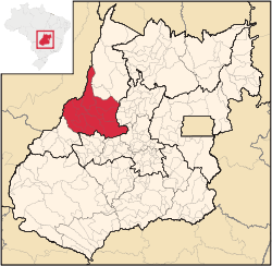 Location in Goias state | |
| Country | Brazil |
| State | Goiás |
| Mesoregion | Noroeste Goiano |
| Municipalities | 9 |
| Area | |
| • Total | 20,277.10 km2 (7,829.03 sq mi) |
| Population (2012) | |
| • Total | 87,890 |
| • Density | 4.3/km2 (11/sq mi) |
The Rio Vermelho Microregion is a geographical region in central Goiás state, Brazil. The most important city is Goiás, also known as Goiás Velho, the only World Heritage Site in the state of Goiás. It takes its name from the Vermelho River, a tributary of the Araguaia River that flows through the region. A region of varied geography with rugged terrain in the south and low watery lands in the north.
Municipalities
The microregion consists of the following municipalities:[1]
- Araguapaz--7,482
- Aruanã--6,476
- Britânia--5,073
- Faina--6,918
- Goiás--24,472
- Itapirapuã--8,208
- Jussara--18,814
- Matrinchã--4,325
- Santa Fé de Goiás--4,594
Population figures are from 2007 and are from Sepin
See also
References
- ↑ Instituto Brasileiro de Geografia e Estatística, territorial division.
Coordinates: 15°56′02″S 50°08′24″W / 15.93389°S 50.14000°W
This article is issued from Wikipedia - version of the 11/1/2016. The text is available under the Creative Commons Attribution/Share Alike but additional terms may apply for the media files.