Goiás
| State of Goiás | |||
|---|---|---|---|
| State | |||
| |||
|
Anthem: Hino de Goiás | |||
 Location of State of Goiás in Brazil | |||
| Coordinates: 15°56′S 50°8′W / 15.933°S 50.133°WCoordinates: 15°56′S 50°8′W / 15.933°S 50.133°W | |||
| Country |
| ||
| Capital and largest city | Goiânia | ||
| Government | |||
| • Governor | Marconi Perillo (PSDB) | ||
| • Vice Governor | José Eliton (PSDB) | ||
| Area | |||
| • Total | 340,086 km2 (131,308 sq mi) | ||
| Area rank | 7th | ||
| Population (2012)[1] | |||
| • Total | 6,155,998 | ||
| • Rank | 12th | ||
| • Density | 18/km2 (47/sq mi) | ||
| • Density rank | 17th | ||
| Demonym(s) | Goiano | ||
| GDP | |||
| • Year | 2006 estimate | ||
| • Total | R$57,091,000,000 (9th) | ||
| • Per capita | R$9,962 (12th) | ||
| HDI | |||
| • Year | 2010 | ||
| • Category | 0.735 – high (8th) | ||
| Time zone | BRT (UTC-3) | ||
| • Summer (DST) | BRST (UTC-2) | ||
| Postal Code | 73700-000 to 76790-000 | ||
| ISO 3166 code | BR-GO | ||
| Website | goias.gov.br | ||

Goiás (Portuguese pronunciation: [ɡojˈjas]) is a state of Brazil, located in the Center-West region of the country. The name Goiás (formerly, Goyaz) comes from the name of an indigenous community. The original word seems to have been guaiá, a compound of gua e iá, meaning "the same person" or "people of the same origin." It borders the Federal District and the states of (from north clockwise) Tocantins, Bahia, Minas Gerais, Mato Grosso do Sul and Mato Grosso.
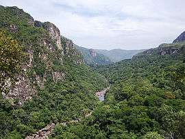
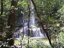
The most populous state of its region, Goiás is characterized by a landscape of chapadões (plateaus). In the height of the drought season, from June to September, the lack of rain makes the level of the Araguaia River go down and exposes almost 2 kilometres (1.2 mi) of beaches, making it the main attraction of the State. At the Emas National Park in the municipality of Mineiros, it is possible to observe the typical fauna and flora from the region. At the Chapada dos Veadeiros the attractions are the canyons, valleys, rapids and waterfalls. Other attractions are the historical city of Goiás (or Old Goiás), 132 km (82 mi) from Goiânia, established in the beginning of 18th Century, and Caldas Novas, with its hot water wells attracting more than one million tourists per year. In Brazil's geoeconomic division, Goiás belongs to the Centro-Sul (Center-South), being the northernmost state of the southern portion of Brazil.
Geography
Located in the east of the Center-West region, and adjacent to Brazil's Southeastern region, Goiás lies on the southern portion of the Brazilian Highlands, which are located in the center of the country. It occupies a large plateau, the vast almost level surface of which stands between 750 and 900 m above sea level and forms the divide between three of Brazil's largest river systems: to the south. Goiás is drained by the Paranaíba river, a tributary of the Paraná River; to the east it is drained by tributaries of the São Francisco River; and northward the state is drained by the Araguaia River and the Tocantins River and their tributaries. Other major rivers in the state are the Meia Ponte, Aporé, São Marcos, Corumbá River, Claro, Paranã, Maranhão, Paranã and Preto. None of these rivers is navigable except for short distances by small craft.
The state's highest point is Pouso Alto, at 1,676 metres (5,499 ft) above sea level, in the Chapada dos Veadeiros.
Goiás is covered with a woodland savanna known in Brazil as campo cerrado, although there are still tropical forests along the rivers. This cerrado has been seriously diminished in recent years due to cattle raising and soybean farming with great loss of animal life and forest cover. The climate of the plateau is tropical. Average monthly temperatures vary from 26 °C (79 °F) in the warmest month to 22 °C (72 °F) in the coldest. The year is divided into a rainy season (October–March) and a dry season (April–September). Average annual rainfall is about 1,700 millimetres (67 in), but this varies due to elevation and microclimate. Some parts of the state, however, have small remnants of tropical Atlantic forest, that mostly appears around rivers and valleys.
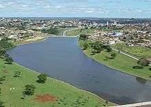
The Great Central West Region, consisting of the states of Goiás, Mato Grosso, Mato Grosso do Sul, and the Federal District, is among the fastest-growing regions of Brazil. The population of Goiás state tripled in size in the period from 1950 to 1980 and is still growing very quickly. However, outside the Federal District and the Goiânia metropolitan region (with a population of over a million) most of Goiás is very thinly populated. The chief concentration of settlement is in the southeast, in the area of Goiânia (Goiânia and Aparecida de Goiânia), across the border from Minas Gerais (Catalão, Rio Verde, Jataí, and Caldas Novas), and around the Federal District (Formosa, Planaltina de Goiás, and Luziânia).
History


The first European exploration of this interior part of Brazil was carried out by expeditions from São Paulo in the 17th century. Gold was discovered in the gravel of a tributary of the Araguaia River by the bandeirante Bartolomeu Bueno da Silva (the Anhanguera) in 1682. The settlement he founded there, called Santa Anna, became the colonial town of Goiás Velho, the former state capital. In 1744 the large inland area, much of it still unexplored by Europeans, was made a Captaincy General, and in 1822 it became a province of the empire of Brazil. It became a state in 1889. The Brazilian constitution of 1891 specified that the nation's capital should be moved to the Brazilian Highlands (Planalto Central), and in 1956 Goiás was selected as the site for the federal district and capital national, Brasília. The seat of the federal government was officially moved to Brasília in 1960.
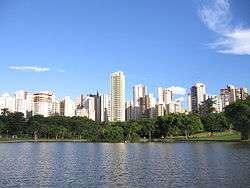
Goiânia, the largest city and capital was planned in 1933 to replace the old, inaccessible former state capital of Goiás, 110 kilometres (68 mi) northwest. In 1937 the state government moved there, and in 1942 the official inauguration was held. Goiânia is now one of the fastest growing cities in Brazil and one of the most livable cities in the country. . It stands out as both an industrial center (along with the neighboring towns of Anápolis and Aparecida de Goiânia) and as a cultural center for country culture and music, known as Sertanejo.
Due to the relatively large territory of the state, which was over 600,000 square kilometres (230,000 sq mi), communications were obviously very difficult. The northern part of the state began to feel abandoned by the southern government and began a movement for separation. Local political leaders, many of whom were large landowners and were eager to gain important positions such as governor or senator and financial gain with the construction of a new capital, also encouraged the movement. In 1989 the northern half of Goiás became a separate state called Tocantins.
Demographics
According to the IBGE of 2010, there were 6,004,045 people residing in the state. The population density was 16.9 inh./km².
Urbanization: 88.6% (2006); Population growth: 2.5% (1991–2000); Houses: 1,749,000 (2006).[2]
The last PNAD (National Research for Sample of Domiciles) census revealed the following numbers: 2,076,000 Pardo (Multiracial) people (49.41%), 3,433,000 White people (51.45%), 329,000 Black people (5.60%), 16,000 Asian people (0.26%), 15,000 Amerindian people (0.25%).[3]
According to an autosomal DNA study from 2008, the ancestral composition of Goiás is 83.70% European, 13.30% African and 3.0% Native American.[4]
| | |||||||||
|---|---|---|---|---|---|---|---|---|---|
| Rank | Mesoregion | Pop. | Rank | Mesoregion | Pop. | ||||
 Goiânia |
1 | Goiânia | [[]] | 1,318,148 | 11 | Itumbiara | [[]] | 93,762 |  Rio Verde |
| 2 | Aparecida de Goiânia | [[]] | 465,092 | 12 | Jataí | [[]] | 88,970 | ||
| 3 | Anápolis | [[]] | 338,544 | 13 | Catalão | [[]] | 88,353 | ||
| 4 | Rio Verde | [[]] | 181,020 | 14 | Senador Canedo | [[]] | 87,848 | ||
| 5 | Luziânia | [[]] | 177,098 | 15 | Planaltina de Goiás | [[]] | 82,258 | ||
| 6 | Águas Lindas de Goiás | [[]] | 163,495 | 16 | Caldas Novas | [[]] | 72,071 | ||
| 7 | Valparaíso de Goiás | [[]] | 135,908 | 17 | Santo Antônio do Descoberto | [[]] | 64,119 | ||
| 8 | Trindade | [[]] | 106,256 | 18 | Goianésia | [[]] | 60,346 | ||
| 9 | Formosa | [[]] | 101,730 | 19 | Cidade Ocidental | [[]] | 57,108 | ||
| 10 | Novo Gama | [[]] | 96,602 | 20 | Mineiros | [[]] | 54,003 | ||
Economy

The service sector is the largest component of GDP at 43.9%, followed by the industrial sector at 35.4%. Agriculture represents 20.7%, of GDP (2004). Goiás exports: soybean 49.2%, meat of cattle 10.5%, gold 9.1%, others meats 7.5%, iron 7.4%, leather 4% (2002).
Share of the Brazilian economy: 2.4% (2005).
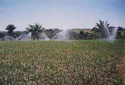
Goiás is a leader in the country in crop raising. The number of cows was estimated in 2000 to be around 18 million, four for every inhabitant. Possibly only Minas Gerais and Rio Grande do Sul have more cattle. Agriculture as a total represented 21% of the GDP of the state, with great production of sugarcane, soybeans, corn, tomato, rice, cotton, manioc and beans.
Minerals are also important with the state being a major producer of nickel, iron, gold, niobium, phosphate and silver.
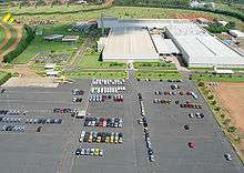
The strongest growing area in the state has been in industry and commerce. Goiânia and Aparecida de Goiânia have become centers of food-processing industries, Anápolis of pharmaceutical factories. Rio Verde, in the southwest, is one of the fastest growing small cities with many new industries locating in the area and Catalão is a metal-mechanical and chemical polo.
Economic indicators
- Agriculture (in tons): sugarcane (9.251.798), soybeans (3.420.653), corn (3.414.601), tomato (759.009), rice (352.135), cotton (278.363), manioc (255.639), beans (200.977)--(1999).
- Livestock (in head): fowl (80.000.000 est.), cattle (18.000.000 est.), pigs (1.000.000 est.) --(1999).
- Minerals: titanium-ilmenite (1.624 t), nickel (52.302 t), manganese (23.242 t), cobalt (484 t), iron (199 brute tons), niobium-pirocloride (54.953 t), gold (4.512.882 grams), silver (211.917)--(1998).
- Industry: food, metallurgy, extraction of non-metallic minerals.
Statistics
- Vehicles: 1,610,972 (March/2007);
- Mobile phones: 3.6 million (April/2007); Telephones: 1.3 million (April/2007)
- Cities: 246 (2007).[6]
Education
Portuguese is the official national language, and thus the primary language taught in schools. But English and Spanish are part of the official high school curriculum.
Educational institutions
- Universidade Federal de Goiás (UFG);
- Instituto Federal de Educação, Ciência e Tecnologia de Goiás (IFG);
- Instituto Federal de Educação, Ciência e Tecnologia Goiano (IFGoiano);
- Universidade Estadual de Goiás (UEG);
- Universidade Paulista (UNIP Flamboyant);
- Pontifícia Universidade Católica de Goiás (PUC GOIÁS);
- Universidade de Rio Verde;
- and many others.
Infrastructure
National airport
Modernization work will soon get under way at Santa Genoveva Airport in the northeast side of Goiânia. With nominal yearly capacity of 600,000 passengers, in 2004 it received 950,000. With its new terminal, it will be able to handle up to 2 million users a year.
Highways
Highways in the Brazilian Highway System include BR-020, BR-040, BR-050, BR-060, BR-070, BR-080, Rodovia Transbrasiliana (BR-153), BR-158, BR-251, BR-364, BR-414, BR-452; additionally, over 60 state highways run through the state.
Ecological issues

To conciliate the expansion of agroindustry and cattle raising with the preservation of the cerrado, one of the richest regions in the world in biodiversity, is one of the main challenges of Goiás. At the same time that it has the third largest cattle herd of the country and occupies first place in grain production, the state faces serious environmental damage.
The expansion of cattle raising especially has caused damage to the cerrado. The native forest has been for the most part destroyed and the permanent reserves gradually cut down to give way to cattle and farming. In the region of the sources of the Araguaia River there are areas of erosion caused by cutting down the trees in order to create pastures. This has produced voçorocas—sudden subsidence of land. Some measure up to 1.5 km. long, 100 meters wide, and 30 meters deep.
These problems, together with the loss of river banks, are causing Goiás to face a serious crisis in water supply, which is exacerbated by the long dry season. Cities like Goiânia, Anápolis, and Luziânia are especially vulnerable, especially since they dump their raw sewage into the rivers that pass through them or nearby.
Air pollution from smoke due to intentionally set fires are also a major problem, especially during the dry season. Fire has been a way of life for ranchers and land-owners for many decades, burning grass and vegetation to clear their property for various reasons. While the same result could be achieved by using hand tools or tractors to clear the land, fire is a cheaper, easier and highly efficient method. Recently, a law was passed banning intentional burning, however, it's not enforced by local law enforcement, and thus intentional burning continues. During the early part of the dry season, local fire departments don't recognize these fires as a life or safety hazard and thus do not respond to extinguish them. Commonly these fires burn through empty lots with low intensity next to and around homes and businesses, bumping the walls and property lines and jumping from lot to lot and across roads. However, most buildings are constructed of brick or masonry, and there is no threat of the structures catching fire when flames impinge on them. As the dry season continues and grasses cure and vegetation dries out, fires become very large in scale and are more intense.
Another problem lies in the locals' habit to burn trash as a method of sanitation removal. Because of the new laws, most burn their trash at night in an attempt to be discreet.
Main sights
- Chapada dos Veadeiros
It is an ecological national park famous for the diversity of its landscape and the richness of its fauna and flora.
- City of Goiás
An internationally famous World Heritage Site, the city is notable for its historical importance and colonial architecture.
- Parque Nacional das Emas
The Emas National Park is another World Heritage Site in Goiás.
- Pirenópolis
Pirenópolis is a picturesque city in the interior of the State of Goiás, famous for its many natural beauties, preserved colonial homes and steep stone streets.
Cities
The 15 most populous cities as estimated in 2008 by IGBE:
- Goiânia (1.265.394)
- Aparecida de Goiânia (494.919)
- Anápolis (331.329)
- Luziânia (203.800)
- Rio Verde (158.818)
- Águas Lindas de Goiás (139.804)
- Valparaíso de Goiás (120.878)
- Trindade (102.870)
- Planaltina de Goiás (94.717)
- Novo Gama (93.081)
- Formosa (90.247)
- Itumbiara (85.724)
- Jataí (76.100)
- Senador Canedo (71.399)
- Catalão (70.574)
See City population of Goiás for table showing population from 1991 to 2005 in the 37 largest cities.
- Cities with touristical interest
| Name | Population |
|---|---|
| Caldas Novas | 65,637 |
| Cristalina | 51,133 |
| Ipameri | 22,600 |
| Pirenópolis | 21,241 |
| Goiás | 14,173 |
| Paraúna | 10,900 |
| Corumbá de Goiás | 9,915 |
| Aruanã | 5,212 |
Flag
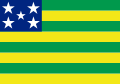
The green bars in the flag symbolize the spring and the yellow bars gold. The blue rectangle in the topleft corner symbolizes the sky, with the five stars forming the constellation of the Southern Cross. The flag was adopted on 30 July 1919. It is a toned down version of the original Republican flag of Brazil, in itself not original.
Notable people
- Amado Batista singer
- Carolina Ferraz, actress
- Cora Coralina, poet
- Henrique Meirelles, president of Banco Central do Brasil
- Ingrid Guimarães, actress
- Leandro e Leonardo, singers
- Léo Jaime, singer and songwriter
- Marconi Perillo, governor
- Marcos Hummel, Rede Record presenter
- Nana Gouvêa, adult model
- Pedro Ludovico political
- Siron Franco, Painter
- Túlio Maravilha, former soccer player
- Wanessa, singer
- Zezé Di Camargo & Luciano, singers
- Paulo Nunes, former soccer player
- Dante Amaral, Brazilian national volleyball team
See also
References
- ↑
- ↑ Source: PNAD.
- ↑ (PDF) (in Portuguese). Goiás, Brazil: IBGE. 2008. ISBN 85-240-3919-1 http://www.sidra.ibge.gov.br/bda/tabela/listabl.asp?z=pnad&o=3&i=P&c=262. Retrieved 2010-01-18. Missing or empty
|title=(help) - ↑ http://bdtd.bce.unb.br/tedesimplificado/tde_busca/arquivo.php?codArquivo=3873
- ↑ "ESTIMATIVAS DA POPULAÇÃO RESIDENTE NOS MUNICÍPIOS BRASILEIROS COM DATA DE REFERÊNCIA EM 1º DE JULHO DE 2011" (PDF) (in Portuguese). Instituto Brasileiro de Geografia e Estatística. 30 August 2011. Archived from the original (PDF) on 31 August 2011. Retrieved 31 August 2011.
- ↑ Source: IBGE.
External links
- (Portuguese) Official Website
- (Portuguese) Historical Cities of Goiás
- (English) Map State of Goiás
-
 Media related to Goiás at Wikimedia Commons
| |||||||||||||||||||||||||
| |||||||||||||||||||||||||