River Marden
| River Marden | |
| River | |
 | |
| Country | United Kingdom |
|---|---|
| Region | Wiltshire |
| Tributaries | |
| - left | Puddington Brook |
| - right | Rivers Brook, Abberd Brook, Fishers Brook, Cowage Brook |
| Source | Ranscombe Bottom |
| - location | Calstone Wellington, near Calne, Wiltshire |
| - elevation | 328 ft (100 m) |
| - coordinates | 51°24′56″N 2°0′48″W / 51.41556°N 2.01333°W |
| Mouth | Bristol Avon |
| - location | near Chippenham, Wiltshire |
| - elevation | 151 ft (46 m) |
| - coordinates | 51°27′56″N 2°05′33″W / 51.46556°N 2.09250°WCoordinates: 51°27′56″N 2°05′33″W / 51.46556°N 2.09250°W |
| Length | 7 mi (11 km) |
| Discharge | |
| - average | 43 cu ft/s (1 m3/s) |
| - max | 1,529 cu ft/s (43 m3/s) |
| - min | 3.9 cu ft/s (0 m3/s) |
The River Marden is a small tributary of the River Avon in England. It flows from the hills surrounding Calne and meets the River Avon about a mile upstream of Chippenham. The river has a mean flow of 43 cubic feet per second (1.2 m3/s).
Course
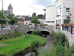
The Marden rises just north of the valley of Ranscombe Bottom near Calstone Wellington in Wiltshire.[1] It then flows in a north west direction through Blacklands Park and Quemerford, where it is joined on the right bank by the Rivers Brook. In Calne, the Abberd Brook joins it on the right and the river turns in a westerly direction and is joined by the overspill from Bowood Lake, part of the Bowood House estate on the left at Studleybrook Farm. The river is then joined by the combined Fishers and Cowage brooks before turning to the north-west, past the village of Stanley. 1.5 miles (2.4 km) later it joins the Bristol Avon to the north east of Chippenham.
History
The Domesday survey of England in 1086 records four watermills on the Marden at Calne. In the 18th century four fulling mills are recorded and one of these, Upper Mill, became a paper mill in 1768 and continued in operation until 1860. Hassell's Mill at Studley remained in operation until 1960. The Wilts & Berks Canal, opened in 1810, paralleled the course of the Marden west of Calne, but it was closed in 1914, following the collapse of the Stanley aqueduct in 1901, although traces still survive.[1][2][3]
Hydrology
The Environment Agency gauging station at Stanley has measured the mean flow of the river as 43 cubic feet per second (1.2 m3/s), with a maximum recorded flow of 1,529 cubic feet per second (43.3 m3/s) on 30 October 2000 and a minimum of 3.9 cubic feet per second (0.11 m3/s) on 21 August 1976.[4]
References
- 1 2 "Calne Without". Wiltshire Community History. Wiltshire Council. Retrieved 2010-01-03.
- ↑ "Swindon Corporation (Wilts and Berks Canal Abandonment) Act, 1914" (PDF). The London Gazette. London Gazette. 31 July 1914. Retrieved 2010-01-03.
- ↑ "A Brief History of the Wilts & Berks Canal". Wilts and Berks Canal trust. Retrieved 2010-01-03.
- ↑ Marsh, Terry; Hannaford, Jamie, eds. (2008). UK Hydrographic Register (PDF). Hydrological data UK series. Wallingford, Oxfordshire: Centre for Ecology & Hydrology. p. 128. ISBN 978-0-9557672-2-7.