Rivera
| Rivera | |
|---|---|
| Capital city | |
|
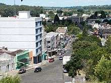
View of Rivera from Cerro Marconi | |
 Rivera Location in Uruguay | |
| Coordinates: 30°54′9″S 55°33′2″W / 30.90250°S 55.55056°WCoordinates: 30°54′9″S 55°33′2″W / 30.90250°S 55.55056°W | |
| Country |
|
| Department | Rivera Department |
| Population (2011) | |
| • Total | 64,465 |
| • Demonym | Riverense |
| Time zone | UTC -3 |
| Postal code | 40000 |
| Dial plan | +598 462 (+5 digits) |
| Climate | Cfa |

Rivera is the capital of Rivera Department of Uruguay. The border with Brazil joins it with the Brazilian city of Santana do Livramento, which is only a street away from it. Together, they form an urban area of around 200,000 inhabitants. As of the census of 2011, it is the sixth most populated city of Uruguay.
Location
The city is located on the border with Brazil at the north end of Route 5.
History
On 21 March 1860 a pueblo (village) named Pereira was created by the Act of Ley Nº 614.
On 7 May 1862, it was substituted by the villa (town) named Ceballos and founded by the Act of Ley Nº 704,[1] in honour of the Spanish viceroy Pedro de Cevallos. In July 1867 it took on the official name Rivera and was recognized as a villa. The Brazilian town Santana do Livramento already existed just across the border. On 1 October 1884, it became capital of the Department of Rivera by the Act of Ley Nº 1.757. Its status was elevated to ciudad (city) on 10 June 1912 by the Act of Ley Nº 4.006.[1]
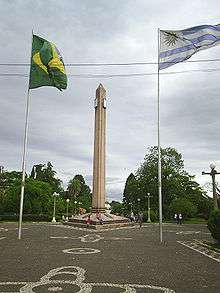
In 1943, the Plaza Internacional Rivera-Livramento (see photo) was built to celebrate the Fifth Conference of the Commission Mixta for Mixed Limits and as a hope for the future integration of the two towns, claimed to be the only international square in the world. From 1851 to this day, inhabitants of both communities are free to move in both sides. Customs and checkpoints are located outside the cities.[2] Today, duty-free shops are one of the main economic resources of Rivera.[3]
Population
In 2011, Rivera had a population of 64,465[4]
| Year | Population |
|---|---|
| 1867 | 341 |
| 1889 | 1,000 |
| 1908 | 8,986 |
| 1963 | 41,266 |
| 1975 | 48,780 |
| 1985 | 57,314 |
| 1996 | 62,859 |
| 2004 | 64,426 |
| 2011 | 64,465 |
Source: Instituto Nacional de Estadística de Uruguay[1]
Places of worship
- Church of the Immaculate Conception (Roman Catholic)
- Parish Church of St. Dominic (Roman Catholic)
- Parish Church of the Sacred Heart (Roman Catholic)
- St. Peter Parish Church (Roman Catholic)
Consular representation
Brazil keeps a Consulate in Rivera, located at 1159 Calle Ceballos.
Notable local people
- Aparicio Méndez, from Rivera, was President of Uruguay from 1976 to 1981. He was never elected democratically and was chosen by the military dictatorship.
- Rodrigo Mora, a current football player for Club Atlético River Plate, was born in Rivera.
Transportation
There are regular bus services to Montevideo. A rail service to Tacuarembó has been run intermittently. There is an airport which receives light aircraft and an irregular service by a Brazilian airline to Porto Alegre.
Rivera is served by Pres. Gral. Óscar D. Gestido International Airport.

Sports
The Estadio Atilio Paiva Olivera holds 27,115 people and was used in the 1995 Copa América.
Thee Skatepark of Rivera is on Presidente Viera Street
Climate
| Climate data for Rivera, Uruguay | |||||||||||||
|---|---|---|---|---|---|---|---|---|---|---|---|---|---|
| Month | Jan | Feb | Mar | Apr | May | Jun | Jul | Aug | Sep | Oct | Nov | Dec | Year |
| Record high °C (°F) | 41.4 (106.5) |
44.0 (111.2) |
40.0 (104) |
34.4 (93.9) |
31.2 (88.2) |
30.2 (86.4) |
29.6 (85.3) |
33.6 (92.5) |
36.1 (97) |
36.4 (97.5) |
41.5 (106.7) |
43.0 (109.4) |
44.0 (111.2) |
| Average high °C (°F) | 30.1 (86.2) |
29.2 (84.6) |
27.1 (80.8) |
23.4 (74.1) |
20.4 (68.7) |
16.9 (62.4) |
17.1 (62.8) |
18.5 (65.3) |
20.3 (68.5) |
23.5 (74.3) |
26.0 (78.8) |
28.8 (83.8) |
23.4 (74.1) |
| Daily mean °C (°F) | 24.1 (75.4) |
23.5 (74.3) |
21.6 (70.9) |
18.1 (64.6) |
15.3 (59.5) |
12.3 (54.1) |
12.3 (54.1) |
13.4 (56.1) |
15.0 (59) |
17.9 (64.2) |
20.5 (68.9) |
22.8 (73) |
18.1 (64.6) |
| Average low °C (°F) | 18.0 (64.4) |
17.9 (64.2) |
16.4 (61.5) |
13.0 (55.4) |
10.1 (50.2) |
7.5 (45.5) |
7.6 (45.7) |
8.4 (47.1) |
9.7 (49.5) |
12.3 (54.1) |
14.4 (57.9) |
16.8 (62.2) |
12.7 (54.9) |
| Record low °C (°F) | 6.0 (42.8) |
7.0 (44.6) |
5.0 (41) |
−3.6 (25.5) |
−1.0 (30.2) |
−5.0 (23) |
−4.8 (23.4) |
−3.0 (26.6) |
−2.4 (27.7) |
0.4 (32.7) |
4.0 (39.2) |
6.4 (43.5) |
−5.0 (23) |
| Average precipitation mm (inches) | 149 (5.87) |
155 (6.1) |
147 (5.79) |
135 (5.31) |
117 (4.61) |
102 (4.02) |
132 (5.2) |
118 (4.65) |
152 (5.98) |
163 (6.42) |
141 (5.55) |
128 (5.04) |
1,639 (64.53) |
| Average precipitation days (≥ 1.0 mm) | 8 | 7 | 8 | 7 | 7 | 8 | 9 | 8 | 8 | 8 | 7 | 6 | 91 |
| Average relative humidity (%) | 69 | 71 | 75 | 78 | 79 | 80 | 80 | 77 | 75 | 73 | 71 | 68 | 75 |
| Mean monthly sunshine hours | 264.3 | 207.2 | 228.4 | 176.0 | 169.4 | 140.0 | 156.8 | 164.3 | 177.8 | 229.4 | 242.9 | 276.6 | 2,433.1 |
| Source: Dirección Nacional de Meteorología (extremes 1944–1994)[5][6] | |||||||||||||
See also
References
- 1 2 3 "Statistics of urban localities (1867–2004) (see also "Ceballos" & "Pereira")" (PDF). INE. 2012. Retrieved 4 September 2012.
- ↑ "Parque Internacional". Intendencia Departamental de Rivera. 2011. Retrieved 26 February 2012.
- ↑ "La frontera dorada". El Observador. 26 June 2011. Retrieved 26 February 2012.
- ↑ "Censos 2011 Cuadros Rivera". INE. 2012. Retrieved 25 August 2012.
- ↑ "Estadísticas climatológicas" (in Spanish). Dirección Nacional de Meteorología. Retrieved 10 October 2012.
- ↑ "RECORDS METEOROLOGICOS EN EL URUGUAY" (in Spanish). Dirección Nacional de Meteorología. Retrieved 28 September 2016.
External links
Capital: Rivera | ||
| Towns and villages | 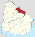 | |
| Sights | ||