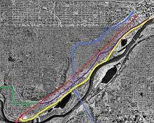
Riverview Corridor
The Riverview Corridor is a transit corridor connecting downtown Saint Paul, Minnesota and the Mall of America in Bloomington via the Minneapolis-Saint Paul International Airport. The corridor serves an area from the Saint Paul Union Depot to the Mall via parts of the METRO Green Line and the METRO Blue Line, and a route running parallel to West 7th Street, which runs southwest from Downtown Saint Paul. The corridor creates a triangle connecting opposite ends of the Blue Line and Green Line.
While several different proposals were discussed, the most discussed was a Bus Rapid Transit line rather than Light rail. Extensive study of the corridor[1] found that limited right-of-way, local opposition, low ridership projections, and high costs limited the potential within the corridor. An Environmental Impact Statement[2] was started on the project in 2002 but never completed. The busway project has been canceled due to a lack of funding from the legislature.
Background to the project
West Seventh Street is also known as Fort Road because the road began as a route to Fort Snelling. The original Fort Road ran further south of West Seventh along the river bluff. Modern day Cliff Street and Stewart Avenue follow around the route of Old Fort Road. The road was platted in 1849 but the route had been used before as the last stretch of an oxcart trail for a fur trading route connecting Canada to Saint Paul via Fort Snelling.[3][4]
West Seventh neighborhood
The West Seventh neighborhood is one of the oldest in Saint Paul. The neighborhood follows along West Seventh Street and is bound on the north by I-35E or the River Bluffs and by the Mississippi River to the South. It formed in the late 1830s from discharged soldiers and other pioneers building houses along the Mississippi River. Later, a boat dock south of Fort Snelling known as the Upper Landing became an important landing spot for dropping off settlers and supplies.[5] The neighborhood grew as waves of settlers and immigrant came to the area to farm or work for local industrial sites. A sizable amount of industry is located between the Mississippi River and south of West Seventh Street.[5] Workers built their houses close to local industry and different ethnic enclaves developed with the different waves of immigrants.[6]

Development tended to spread southwest from the Upper Landing, later known as Uppertown, southwest to Fort Snelling along Fort Road. By 1884 a horse drawn street car line traveled along a portion of West Seventh Street. The streetcar line later became electrified by 1891.[7] The line extended to Tuscarora Street by 1890 and to river bluff by 1891. Four other lines also traveled partially along the corridor on their path to Downtown. The line stopped just short of Fort Snelling on the Saint Paul side of Fort Road Bridge. The lack of an extension to Fort Snelling became undesirable to soldiers who wanted an easy connection to the city and civilians who worked on the military reservation. After a new bridge was constructed in 1909 the line was extended to the other side of the river. A free streetcar shuttle was constructed in Fort Snelling that met with the West Seventh line and then traveled in a single track in Fort Snelling. The Fort Snelling shuttle stopped operating in 1952 and the streetcar line was converted to a bus line in 1952 along with the rest of the Twin Cities transit system.[8]
The Minneapolis-Saint Paul International Airport was constructed near Fort Snelling in 1921. When it became a major transit hub the corridor was extended to the airport. In the 1989 a county transit plan for Ramsey County was made. The corridor between the airport and Downtown Saint Paul was considered an important corridor.[9] When the Mall of America was constructed the corridor was extended to the mall. The route was first named the Riverview Corridor in February 1997 after the Ramsey County board unanimously voted the corridor as a higher priority than the Central Corridor.[9]
Difficulty constructing I-35E
The federal government as part of the Interstate Highway System began to plan for a missing link of Interstate 35E. The type of connection and location of the connection were both met with controversy. The missing piece through the West Seventh neighborhood, from State Highway 5 (West 7th Street) northeast to I-94 in downtown Saint Paul, was held up by controversy. Construction began in 1964, and was planned for completion in the 1970s as a typical six-lane freeway, but the National Environmental Policy Act was passed on January 1, 1970. In late 1969, Residents in Protest 35E (R.I.P. 35E) formed to oppose the completion of I-35E. The group convinced the city to drop its support, and in August it filed a lawsuit which successfully halted construction pending an environmental impact statement (EIS).[10] The Saint Paul City Council decided in late 1974 to support I-35E but later changed its support a R.I.P. 35E proposed alternative. The plan included a four-lane boulevard upgrade of Pleasant Avenue (the street chosen for the I-35E alignment), with another route such as Shepard Road or the nearby Lafayette Freeway forming part of I-35E. The group opposed any direct connection to I-94 near the State Capitol, where I-35E and I-94 were to merge. The EIS was completed in early 1975, identifying the primary benefit of completing I-35E to be connecting downtown Saint Paul to the Interstate Highway System, and the EIS determined that the original Pleasant Avenue corridor was the best choice.[10]
A bill passed by the Minnesota Legislature on May 31, 1975, imposed a moratorium on building I-35E while allowing several possible state highway routes that could be added to the Interstate Highway System. Two routes offered a direct connection to I-94, while a third was a parkway with no direct connection. Saint Paul changed its mind again in September 1981, supporting a direct connection, along with Mn/DOT and the Metropolitan Council. A bill passed in March 1982 removed the stipulation that the parkway shall not connect to I-94, and allowed (I-35E) to use the parkway route. The final EIS was approved at about that time, and several groups including R.I.P. 35E filed suit in early 1983.[10] The EIS was ruled valid and construction went forward. I-35E was opened from Highway 5 north to I-94 on October 15, 1990, 26 years after construction began.[11]
Alignment
There are several different variations of the corridor but all of them have the Mall of America as one terminus and the Airport and Downtown Saint Paul as destinations. There were four possible routes along this section of the corridor; West Seventh Street, Interstate 35E, Shepard Road and along Canadian Pacific Railway tracks.[12] West Seventh Street would be the most direct route but the right of way would need to be expanded. Interstate 35E already had an available right of way but created a longer route and bypassed many stretches of the West Seventh Neighborhood. Shepard Road is a direct route to Downtown but is out of the way of many ride generating places. The Canadian Pacific Railway right of way follows roughly along West Seventh but would be difficult to acquire the right of way rights.
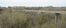
Every route requires crossing the Mississippi River from Saint Paul to Fort Snelling. The current Fort Road Bridge was built in 1960 by the Minnesota Department of Transportation and was designed by Sverdrup & Parcel Engineering Company. It is the third bridge on the site, the first bridge, a deck girder bridge was built in 1880. The second bridge, a metal arch bridge was built by 1912. While almost all of the proposed routes would use the Fort Road Bridge, one suggested using a rail spur north and using the Ford Parkway Bridge upstream. Both routes would have had potential problems with the adaptation of the current bridge. When using the Fort Road Bridge, it was unknown if it could handle light rail or if a tunnel on the Fort Snelling side of the bridge could be widened. If the Ford Parkway bridge was used there were additional concern with the alignment of the route to the bridge.[13] The second bridge at the Fort Road site and the Ford Parkway Bridge had held streetcar traffic.[14]
History of transit corridor
The corridor was first identified for transit improvements around 1989 as part of regional transit studies. The route was first named the Riverview Corridor in February 1997 after the Ramsey County board unanimously voted the corridor as a higher priority than the Central Corridor.[9] A study in 1998 by the Ramsey County Rail Authority determined that light rail would not be cost effective and that a busway would be the more viable.[12] During the 2000 Minnesota legislative session there was a $525 million budget surplus of new ongoing state revenue. In order to compromise, the surplus would be split and spent with one third of the money each going to the House, the Senate and the Governor. Governor Jesse Ventura decided to use his $175 million portion of the surplus to lower auto license fees. After finding out it would be cheaper than expected Ventura agreed to allocate $44 million to a busway project. While the Riverview Corridor was not specifically mentioned, it was generally understood to be for the Corridor.[15][16][17]
Plans for the corridor soon developed and the route was finalized. The line would run along West Seventh street through the East Side of Saint Paul to the Maplewood Mall by 2004 with service increasing to every 7.5 minutes. Unlike the then Bus Route the new service would travel along West Seventh the entire way to Downtown rather than taking I-35E.[18] They included widening West Seventh, from I-35E to Smith Avenue, by 4 feet in order to create bus-only lanes.[19] Traffic signals would have been timed so buses would have priority. The section along the Phalen Corridor would become a dedicated transitway. There would have been 23 stations with the option to have pre-boarding fare collection.[20][21]
The bill for the busway was inserted into an unrelated bill in conference committee in the last weekend of the legislative session with no legislative hearings. The method was described as "in clear violation of legislative rules."[16] House Republicans opposed the project but acquiesced in order to end the legislative session.[22] Critics of the Riverview Corridor argued that it would duplicate service of the Metro Transit Bus Route 54. The Route travels along the Corridor from the Mall of America to Downtown Saint Paul.[18] There were also concerns about the low ridership projections. Only 16,000 people a day for light rail and only 12,000 a day on a busway were projected to travel along the route.[23] The project was supported much more on Saint Paul's Eastside than along West Seventh Street.[21] West Seventh residents and businesses were concerned about loss of parking and sidewalk space because of the need to expand the street by 4 feet.[21] In March 2002, $40 of the $46.1 million devoted to the project was taken back by the Legislature in order to balance the State's budget. The project was cut largely due to opposition and lack of strong support.[19]
In 2002 plans were announced to introduce improved interim bus service along a portion of Route 54. The plan changed Route 54 from traveling along Interstate 35E from West Seventh to Downtown Saint Paul, to entirely along West Seventh and operating every 15 minutes as opposed to every 30 minutes. The change added 3 minutes to the 20 Minute trip from the Airport to Downtown and the 30 minutes trip from the Mall of America to Downtown.[18] When money from the project was cut in March 2002, this was the extent of the Route's improved service. Plans to change and improve service reappeared when Metro Transit redesigned their service in 2003.[24][25] Bus Route 69 from Maplewood Mall to along West Seventh via Downtown Saint Paul had its route west of Downtown, along West Seventh, eliminated. In 2004 bus Route 54 was changed to its current form. It is currently a limited stop route and is one of 12 routes that operate as a Hi-Frequency route with service every 15 minutes or better.[26] It is one of three routes that operates as a Hi-Frequency Route along its entire route.[26]
Current status
The Riverview Corridor route is still considered an important corridor by the Metropolitan Council. In the Metropolitan Council's 2030 Transportation Policy Plan, West Seventh Street and East Seventh Street are two of nine arterial streets that are recommended for bus rapid transit.[27] The arterial bus rapid transit ways are located in built up areas that have limited right of ways, making light rail or dedicated bus ways not feasible. The corridors would have limited stop service and use technology improvements to shorten trip times. The Metropolitan Council plans to build six of the nine by 2020 and the rest by 2030. Some of the corridors are also being studied for other transit modes.[28]
On January 23, 2013, the Saint Paul City Council voted in favor of requesting the Ramsey County Regional Rail Authority to conduct a new transit study of the Riverview Corridor.[29] The Ramsey County Regional Railroad Authority is leading the Pre-Project Development (PPD) Study to research, analyze and identify opportunities to improve transit within the Riverview Corridor. This study is scheduled for completion in late 2015 and will involve reviewing the viability of transit modes, transit location, engineering issues, community needs and preferences, and estimated costs.
The PPD Study will include an extensive public involvement and outreach effort to assure community input helps to inform the Study’s vision and the results of the analysis.[30] Policy makers will use the results of the Riverview PPD Study to select a locally preferred alternative for the corridor. The choice will then advance into a more detailed study.
External links
2014 PrePlanning Development Study Website www.riverviewcorridor.com
Footnotes
- ↑ Major Investment Study, 2000
- ↑ Environmental Impact Statement or Possible Environmental Assessment on the Riverview Corridor Transit Project Located in the Cities of St. Paul and Bloomington, MN | Federal R...
- ↑ Empson, Donald; Gary Brueggeman (1980). Kathleen Vadnais, ed. Portrait of a Neighborhood. West 7th Federation. p. 4.
- ↑ Empson, Donald L. (2006). The Street Where You Live. Minneapolis, Minnesota: University of Minnesota Press. p. 242. ISBN 978-0-8166-4729-3.
- 1 2 "District 9: West Seventh Street". Ramsey County Historic Site Survey Report. Ramsey County Historical Society. Retrieved 2010-08-29.
- ↑ Empson, Donald; Gary Brueggeman (1980). Kathleen Vadnais, ed. Portrait of a Neighborhood. West 7th Federation. pp. 4–9.
- ↑ Kieffer, Stephen A. (1958). Transit and the Twins. Twin Cities Rapid Transit Company. pp. 9, 20.
- ↑ W. Diers, John; Isaacs, Aaron (2007). Twin Cities by trolley: the streetcar era in Minneapolis and St. Paul. Minneapolis: University of Minnesota Press. pp. 242, 260. ISBN 978-0-8166-4358-5.
- 1 2 3 Baker, Ann (February 5, 1997) "RAMSEY COUNTY BOARD CHANGES TRANSIT COURSE//HIGH-SPEED ROUTE IS SOUGHT FROM ST. PAUL TO AIRPORT, MEGAMALL" Saint Paul Pioneer Press
- 1 2 3 Patricia Cavanaugh,Politics and Freeways: Building the Twin Cities Interstate System (Publication No. CURA 06-01), University of Minnesota Center for Urban and Regional Affairs and Center for Transportation Studies, October 2006
- ↑ Sean T. Kelly, St. Paul Pioneer Press, Last Mile of I-35E Opens in St. Paul After 19-Year Wait, October 16, 1990, p. 1B
- 1 2 Karlson, Karl J. (June 4, 1998) "STUDY: LIGHT RAIL POOR OPTION FOR RIVERVIEW CORRIDOR //BUSES BETTER FOR LINKING DOWNTOWN ST. PAUL, AIRPORT" Saint Paul Pioneer Press
- ↑ "2030 Master Transit Study" (PDF). Metro Transit. p. 25. Retrieved 2010-08-26.
- ↑ W. Diers, John; Isaacs, Aaron (2007). Twin Cities by trolley: the streetcar era in Minneapolis and St. Paul. Minneapolis: University of Minnesota Press. pp. 242, 260. ISBN 978-0-8166-4358-5.
- ↑ Salisbury, Bill (May 10, 2000) "Near the Finish Line/Education Wins Big in Bonding Bill" Saint Paul Pioneer Press
- 1 2 Dornfield, Steven (May 11, 2000) "Legislative Slight of Hand// With Some Deft Skirting of the Rules, Gov. Ventura and Legislators Find a Last-Minute Way to Initiate a Bus-Oriented East Metro Transit Plan That Will Connect St. Paul to the Airport and the Mall of America." Saint Paul Pioneer Press
- ↑ Pattison, Kermit (May 11, 2000) "ST. PAUL RIVERVIEW CORRIDOR EYED FOR BUSWAY //EXPRESS ROUTE WOULD RUN FROM DOWNTOWN TO MEGAMALL, AIRPORT" Saint Paul Pioneer Press
- 1 2 3 Coleman, Toni (January 16, 2002) "Riverview Busway to Replace Route 54 //Metro Transit will Start Service March 16" Saint Paul Pioneer Press
- 1 2 Coleman, Toni (March 1, 2002) "Busway Project Put on Hold//Budget Bill REclaims Most of State Funding" Saint Paul Pioneer Press
- ↑ Coleman, Toni (October 23, 2001) "EAST METRO BUSWAY PLAN SCALED BACK//CITIZEN REACTION LEADS OFFICIALS TO ALTER DESIGN OF TRANSIT SYSTEM" Saint Paul Pioneer Press
- 1 2 3 Coleman, Toni (November 7, 2001) "East Side Welcomes Coming of Busway//Reception is in Contrast with West Seventh's"Saint Paul Pioneer Press
- ↑ Whereatt, Robert (February 16, 2002) "House bill would cut out planned St. Paul busway - The move, part of budget-balancing efforts, would aim to reclaim $40 million of the $44 million Riverview Corridor project."Saint Paul Pioneer Press
- ↑ Coleman, Toni (August 23, 2000) "Options Detailed for East Metro Transit//Light Rail, Busway Among Riverview Corridor Choices" Saint Paul Pioneer Press
- ↑ Coleman, Toni (January 6, 2003) "EXPRESS BUS MAY COME TO WEST SEVENTH AFTER ALL" Saint Paul Pioneer Press
- ↑ Blake, Laurie (January 12, 2003) "Bus service improvements ahead" Star Tribune
- 1 2 Hi-Frequency Service Network
- ↑ "2030 Transportation Policy Plan Summary" (PDF). 2030 Transportation Policy Plan. Metropolitan Council. pp. 6–7.
- ↑ "Chapter 7: Transit" (PDF). 2030 Transportation Policy Plan. Metropolitan Council. p. 143.
- ↑ "City of Saint Paul Council Meeting Minutes". City Council Meeting Minutes. City of Saint Paul. pp. 1–2.
- ↑ http://www.riverviewcorridor.com