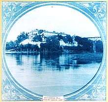
Fort Snelling
|
Fort Snelling | |
|
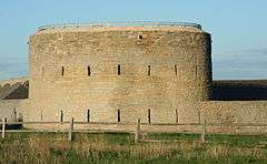
Fort Snelling's round tower | |
 | |
| Location | Hennepin County, Minnesota, USA |
|---|---|
| Nearest city | Across Mississippi River from Saint Paul, at 7th Street Bridge, St. Paul, Minnesota |
| Coordinates | 44°53′34″N 93°10′50″W / 44.89278°N 93.18056°WCoordinates: 44°53′34″N 93°10′50″W / 44.89278°N 93.18056°W |
| Built | 1819 |
| Architect | Colonel Josiah Snelling |
| Website | http://www.historicfortsnelling.org |
| NRHP Reference # | 66000401 |
| Significant dates | |
| Added to NRHP | 15 October 1966[1] |
| Designated NHL | 19 December 1960[2] |
Fort Snelling, originally known as Fort Saint Anthony, was a military fortification located at the confluence of Minnesota and Mississippi Rivers in Hennepin County, Minnesota. Mississippi National River and Recreation Area, a National Park Service unit, includes historic Fort Snelling.
Fort Snelling also refers to an unorganized territory in Hennepin County, Minnesota, containing the former fortification. The Census in 2000 enumerated a total population of 442.
The Minnesota Historical Society now runs the fort, located atop a bluff along the river. Minnesota Department of Natural Resources runs Fort Snelling State Park, protecting the land at the bottom of the bluff. Fort Snelling once encompassed both parcels.
The fort is a National Historic Landmark and has been named a "national treasure" by the National Trust for Historic Preservation.[3]
History
Origins
Lieutenant Zebulon Pike in 1805 acquired Pike's Purchase for the United States, comprising 100,000 acres (400 km²) of land in the area. Significant settlement began in the late 1810s. Following the War of 1812, the United States Department of War built a chain of forts and installed Indian agents between Lake Michigan and the Missouri River. These forts primarily protected the northwestern territories from Canadian and British encroachment. The Army founded Fort Saint Anthony in 1819.
Colonel Josiah Snelling commanded the 5th Infantry Regiment (United States). Its soldiers constructed the original Fort Saint Anthony from 1820 to 1824. During construction, most soldiers lived at Camp Coldwater, which provided drinking water to the fort throughout the 19th century. The post surgeon began recording meteorological observations at Fort Saint Anthony in January 1820, beginning one of the longest near-continuous weather records in the country. Upon its completion in 1825, the Army renamed the fort as Fort Snelling in honor of its commander and architect.
Frontier post
The soldiers at the northwestern frontier outposts tried to restrict commercial use of the rivers to United States citizens, keep American Indian lands free of white settlement until treaties permitted it, enforce law and order, and protect legitimate travelers and traders. At Fort Snelling, the garrison also attempted to keep the peace between the Dakota people.[4]
Colonel Snelling suffered from chronic dysentery, and bouts of the illness made him susceptible to anger. Recalled to Washington, he left Fort Snelling in September 1827. Colonel Snelling died in summer 1828 from complications due to dysentery and a "brain fever".
In 1830 Fort Snelling was the birthplace of John Taylor Wood, who later became known as a lieutenant in the Confederate navy, serving on board the Merrimack at the Battle of Hampton Roads.[5]
John Emerson purchased the slave Dred Scott in Saint Louis, Missouri, but he later worked and lived at Fort Snelling during much of the 1830s, having brought Dred and his wife Harriet Scott with him. The Missouri Compromise made slavery illegal in Minnesota Territory. Emerson took the Scotts back to Missouri, a slave state, where they sued for their freedom and that of their daughters, because they had been held illegally in a free territory. A longstanding precedent of "once free, always free" was overturned in this case, and the United States Supreme court case of Dred Scott v. Sandford (1857) ruled that the Missouri Compromise was unconstitutional and that African Americans had no standing under the constitution.
Career Army officer and artist Seth Eastman had two tours here, the second a lengthy one in the 1840s when he commanded the fort.[6][7] He did many paintings and drawings of the Dakota and other Native American peoples while here, and helped record their customs and lives.[8] He was commissioned by Congress to illustrate the six-volume study of Indian Tribes of the United States by Henry Rowe Schoolcraft, which was published 1851-1857 with hundreds of his works.[9]
As the towns of Minneapolis and Saint Paul, Minnesota were developed in this area and increased in population, there was less need for a forward frontier military post in the region. The Army sold Fort Snelling to Franklin Steele in 1858 for $90,000. (Fortunately for Steele, the deal included 8000 acres (32 km²) later annexed into south Minneapolis.)[10]
Civil War and afterwards
During the American Civil War, Franklin Steele leased Fort Snelling back to the War Department for use as an induction station. More than 24,000 recruits from Minnesota were trained here.[11] During the Dakota War of 1862, the Army used it as the base of a concentration camp, holding hundreds of Dakota women, children, and elders as captives on the river flats below the fort through the winter of 1862–63. Hundreds died there.[12] After the war, Steele leased the land around Fort Snelling to settlers, and Minneapolis began to expand into the fort's surroundings.[13]
The United States Army assigned a garrison to Fort Snelling. The fort dispatched forces to protect the interests of the colonizers on the frontier from the Dakota people, westward to the Rocky Mountains. Soldiers from Fort Snelling fought in the Indian Wars and the Spanish–American War of 1898.[4]
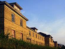
Through World War II, the War Department chose Fort Snelling as the location for the Military Intelligence Service Language School to teach the Japanese language to Army personnel. The War Department constructed scores of buildings for housing and teaching, and the school processed 300,000 soldiers.[4][10] The school was relocated to Monterey, California after the war, in June 1946.[14]
Second decommissioning
The War Department decommissioned Fort Snelling on 14 October 1946, and various federal agencies took parcels from the grounds of the old fort. The majority of the structures fell into disrepair. In 1960, it was listed as a National Historic Landmark, citing its importance as the first major military post in the region, and for its later history in the development of the United States Army.[2][15]
Fort Snelling nevertheless continued to serve as headquarters of United States Army Reserve 205th Infantry Brigade, which comprised three light infantry battalions and attached field artillery, cavalry, air defense artillery, combat engineers, and supporting logistics units throughout the Upper Midwest. The Defense Department deactivated this unit in 1994 as a part of force-structure eliminations. Over the decades, the Army interred many deceased Minnesotan soldiers and other members of the United States Armed Forces at Fort Snelling National Cemetery. Some military facilities continue to operate around old Fort Snelling.
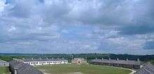
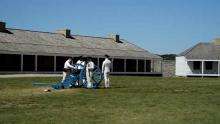
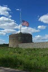
The Minnesota Historical Society has converted the area of the original walled fort into an educational establishment, rebuilt to resemble its original appearance, and staffed during the spring, summer and early fall with costumed personnel interpreting life at the early post. Although restoring and re-creating the original fort assures its survival as a historical artifact for the foreseeable future, many briefly used buildings of the fort gradually fell into serious disrepair and neglect. In May 2006, the National Trust for Historic Preservation added Upper Post of Fort Snelling to its list of "America's Most Endangered Places". Some restoration on historic Fort Snelling continues, and crews removed the flagpole from the iconic round tower and placed it in the ground, a change since its opening as a historic fort.
The United States Navy named an amphibious warfare ship, the USS Fort Snelling (LSD-30), to honor the fort.
Geography
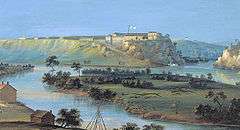
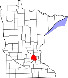
The fort is located on Fort Snelling Unorganized Territory, an unincorporated area and division of Hennepin County lying just east of the city of Richfield. It is also adjacent to the cities of Minneapolis, Bloomington, Saint Paul (across the Mississippi River), and Mendota Heights (across the Minnesota River). The fort is located at the eastern end of the territory, near the confluence of the Mississippi River with the Minnesota River.
(View in high quality)
Fort Snelling unorganized territory contains numerous military and other federal facilities. These facilities include historic Fort Snelling, its cemetery, and the Minneapolis Veterans Health Administration Medical Center. Minneapolis–St. Paul International Airport, however, includes most of the land area of the unorganized territory. According to the United States Census Bureau, this unorganized territory has a total area of 17.2 km² (6.7 mi²). 16.5 km² (6.4 mi²) of it is land and 0.8 km² (0.3 mi²) of it is water.
Demographics
As of the census[16] of 2000, 442 people reside in the unorganized territory. The population density is 26.8/km² (69.5/mi²). The racial makeup of the unorganized territory is 94.57% White, 3.62% Black or African American, 1.36% Native American, 0.00% Asian, 0.23% Pacific Islander, and 0.23% of other races. 0.45% of the population is Hispanic or Latino of any race.
The population is spread out with 4.5% from 25 to 44, 33.0% from 45 to 64, and 62.4% who are 65 years of age or older. The median age is 69 years.
Males had a median income of $43,558 versus $0 for females. The per capita income is $24,328. None of the population is below the poverty line.
Airport and economy
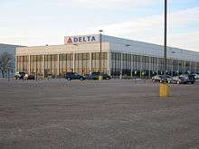
Delta Air Lines Building C is located on the property of Minneapolis–St. Paul International Airport and in Fort Snelling.[17][18][19][20] Delta uses it for northern and regional operations.[21]
In 2009, as Northwest Airlines and Delta Airlines merged, Delta removed all employees from Building A, the previous headquarters of Northwest in Eagan, and all employees who remained in Minneapolis were moved to Building C, which was renovated.[22] Facilities within the building include the Compass Airlines corporate headquarters, which moved there on December 16, 2009.[23] the Regional Elite Airline Services headquarters,[24] and Delta SkyBonus offices.[25]
Prior to its disestablishment, Republic Airlines (1979–1986) had its headquarters in Building C.[21][26] At various times both Mesaba Airlines and MAIR Holdings had their headquarters in the Fort Snelling UT.[18][27][28]
See also
- Army on the Frontier
- Dred Scott
- Fort Snelling State Park
- Lawrence Taliaferro
- List of National Historic Landmarks in Minnesota
- National Register of Historic Places listings in Hennepin County, Minnesota
References
- ↑ National Park Service (2006-03-15). "National Register Information System". National Register of Historic Places. National Park Service.
- 1 2 "Fort Snelling". National Historic Landmark summary listing. National Park Service. Retrieved 2007-10-03.
- ↑ Feshir, Riham (April 20, 2016). "Historic Fort Snelling named 'national treasure'". MPR News. Minnesota Public Radio. Retrieved April 20, 2016.
- 1 2 3 "Historic Fort Snelling: A Brief History of Fort Snelling". Minnesota Historical Society. Retrieved 2007-05-30.
- ↑ Winstead, 2009
- ↑ Patricia Condon Johnston, "Seth Eastman: The Soldier Artist", PBS, accessed 11 December 2008
- ↑ "Seth Eastman". United States Army Center of Military History. December 1, 2009. Retrieved June 16, 2010.
- ↑ "Seth Eastman", Library: History Topics, Minnesota Historical Society, 2011, accessed 3 February 2011
- ↑ "West Point, New York by Seth Eastman", with bio, US Senate, accessed 29 September 2009
- 1 2 "Fort Snelling State Park Upper Bluff Reuse Study" (PDF). Minnesota Department of Natural Resources. November 1998. Archived from the original (PDF) on 2008-03-07. (Archive)
- ↑ "The Civil War". Historic Fort Snelling. Minnesota Historical Society. Retrieved July 6, 2013.
- ↑ "Forced Marches & Imprisonment". The U.S.-Dakota War of 1862. Minnesota Historical Society. Retrieved July 6, 2013.
- ↑ "Urban Connections – Minneapolis". USDA Forest Service. Retrieved 2007-05-29.
- ↑ Yamashita, Jeffrey T. "Fort Snelling" Densho Encyclopedia. Retrieved on July 3, 2014.
- ↑ Marilynn Larew (March 15, 1978). "National Register of Historic Places Inventory-Nomination: Fort Snelling" (PDF). National Park Service. Retrieved 2009-06-21. and Accompanying 29 images, including photos from late 1880s to 1977. (6.55 MB)
- ↑ "American FactFinder". United States Census Bureau. Retrieved 2008-01-31.
- ↑ "delta air lines' farmers market-building c". Minneapolis–St. Paul International Airport. Retrieved on January 19, 2012. "Location: MSP Airport-Delta Building C, North Side near Compass Airlines Entrance"
- 1 2 "Fort Snelling UT, Hennepin county, Minnesota". (Archive) U.S. Census Bureau. Retrieved on December 19, 2009.
- ↑ "Expanded Branch and ATM Access Comes to the Twin Cities". Wings Financial. Retrieved on January 19, 2012. "Delta Air Lines Bldg. C* 7500 Airline Drive Minneapolis, MN"
- ↑ "Blood Drive | Delta Air Lines Bldg C". Memorial Blood Centers. Retrieved on January 19, 2012. "Street: 7500 Airline Drive City: Bloomington State: Minnesota Country: USA"
- 1 2 Niemela, Jennifer. "Delta reaches deal on Minnesota jobs". Minneapolis / St. Paul Business Journal. Tuesday December 16, 2008. Retrieved on January 19, 2012.
- ↑ Grayson, Katharine. "Delta CEO: We'll consolidate MSP office space". Minneapolis / St. Paul Business Journal. Friday June 12, 2009. Last modified on Monday June 15, 2009. Retrieved on January 19, 2012.
- ↑ "About Us". Compass Airlines. Retrieved on December 18, 2009. "7500 Airline Drive Suite 130 Minneapolis, Minnesota 55450"
- ↑ "CR-7010-Docket.pdf". Unity and Strength For Workers. Retrieved on January 19, 2012. "Regional Elite Airline Services 7500 Airline Drive C079 Minneapolis, MN 55450-1101"
- ↑ "Contact us". Delta SkyBonus. Retrieved on January 19, 2012. "SkyBonus® MS3-746 7500 Airline Drive Minneapolis, MN 55450"
- ↑ "World Airline Directory". Flight International. March 30, 1985. 111.
- ↑ "World Airline Directory". Flight International. March 23–29, 1994. 106. "Head office: 7501 26th Avenue South, Minneapolis, Minnesota 55450, USA"
- ↑ "2001 Annual Report". MAIR Holdings. Retrieved on August 16, 2011. " 7501 26th Avenue South Minneapolis, Minnesota 55450"
Other sources
- Winstead, Tim (2009). "John Taylor Wood: Man of Action, Man of Honor".
Wilmington, North Carolina: The Cape Fear Civil War Round Table. Retrieved Oct 7, 2013.
Further reading
- Anfinson, John O. (2003). River of History: A Historic Resources Study of the Mississippi National River and Recreation Area. St. Paul District, Corps of Engineers.
External links
| Wikimedia Commons has media related to Fort Snelling. |
- Round Tower, Fort Snelling in MNopedia, the Minnesota Encyclopedia
- Three Score Years and Ten – Life-Long Memories of Fort Snelling, Minnesota, and other parts of the West, by Charlotte Ouisconsin Van Cleve. Published in 1888, from Project Gutenberg
- Fort Snelling National Cemetery, Department of Veterans Affairs Official webpage
- Minneapolis VA Medical Center, Department of Veterans Affairs Official webpage
- Minneapolis-St. Paul International Airport Official website
- NHL summary
- National Register of Historic Places Nomination Form – includes description and details on buildings
- Historic Fort Snelling page of the Mississippi National River and Recreation Area's website
| Topics | |
|---|---|
| Lists by states |
|
| Lists by insular areas | |
| Lists by associated states | |
| Other areas | |
| |
Municipalities and communities of Hennepin County, Minnesota, United States | ||
|---|---|---|
| Cities |
|  |
| Unorganized territory | ||
| Footnotes | ‡This populated place also has portions in an adjacent county or counties | |
