Rivière-Ouelle
| Rivière-Ouelle | |
|---|---|
| Municipality | |
 | |
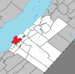 Location within Kamouraska RCM | |
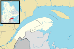 Rivière-Ouelle Location in eastern Quebec | |
| Coordinates: 47°26′N 70°01′W / 47.433°N 70.017°WCoordinates: 47°26′N 70°01′W / 47.433°N 70.017°W[1] | |
| Country |
|
| Province |
|
| Region | Bas-Saint-Laurent |
| RCM | Kamouraska |
| Constituted | July 1, 1855 |
| Government[2] | |
| • Mayor | Elizabeth Hudon |
| • Federal riding | Montmagny—L'Islet—Kamouraska—Rivière-du-Loup |
| • Prov. riding | Côte-du-Sud |
| Area[2][3] | |
| • Total | 147.10 km2 (56.80 sq mi) |
| • Land | 56.75 km2 (21.91 sq mi) |
| Population (2011)[3] | |
| • Total | 1,058 |
| • Density | 18.6/km2 (48/sq mi) |
| • Pop 2006-2011 |
|
| • Dwellings | 620 |
| Time zone | EST (UTC−5) |
| • Summer (DST) | EDT (UTC−4) |
| Postal code(s) | G0L 2C0 |
| Area code(s) | 418 and 581 |
| Highways | |
| Website |
www |
Rivière-Ouelle is a town located in the Kamouraska Regional County Municipality within the Bas-Saint-Laurent region of Quebec. It is located on the Saint Lawrence River; the Ouelle River flows through the town. It was part of the seignory of La Bouteillerie, once owned by Charles Deschamps de Boishébert et de Raffetot. Jean-Charles Chapais, a Father of Canadian Confederation, was born here.
Geography
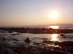
Rivière-Ouelle lies on the south shore of the Saint Lawrence River.
Communities and locations
The following designated areas reside within the municipality's boundaries:[1]
- De Saint-Just (47°27′07″N 70°00′05″W / 47.45194°N 70.00139°W) – a hamlet located on Route 132
- Pointe-aux-Orignaux (47°29′07″N 70°01′21″W / 47.48528°N 70.02250°W) – a hamlet located on Anse de Mercier (Mercier Bay)
- Pointe-de-Rivière-Ouelle (47°26′02″N 70°03′01″W / 47.43389°N 70.05028°W) – a hamlet located on the shore of the Saint Lawrence River
Municipal council
- Mayor: Roger Richard
- Councillors: Éric Bérubé, Gilles Hudon, Gilles Levesque, Dominic Morin, Marie-Pierre Richard, Daniel Scherer
See also
References
External links
-
 Media related to Rivière-Ouelle at Wikimedia Commons
 |
Les Éboulements Saint Lawrence River |
Saint-Irénée / La Malbaie Saint Lawrence River |
Saint-Denis-De La Bouteillerie | |
| |
Saint-Philippe-de-Néri | |||
| ||||
| | ||||
| La Pocatière | Sainte-Anne-de-la-Pocatière | Saint-Pacôme |
| Cities & Towns | |
|---|---|
| Municipalities | |
| Parishes | |
| Unorganized territories | |
| |
This article is issued from Wikipedia - version of the 12/1/2016. The text is available under the Creative Commons Attribution/Share Alike but additional terms may apply for the media files.