Roebuck Bay
Roebuck Bay is a bay on the coast of the Kimberley region of Western Australia. Its entrance is bounded in the north by the town of Broome, and in the south by Bush Point and Sandy Point. It is named after HMS Roebuck, the ship captained by William Dampier when he explored the coast of north-western Australia in 1699. The Broome Bird Observatory lies on the northern coast of the bay.
Description
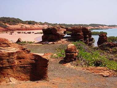
Roebuck Bay is a 550 km2 (210 mi2) tropical, marine embayment. It has red sandy beaches and areas of mangroves, with the eastern edge of the bay being made up of linear tidal creeks. It is surrounded by grasslands and pindan woodland.[1][2]
The northern shore of the bay is dominated by a long and low red cliff, 2–6 m in height, of pindan soil which gives the beaches there their distinctive red colouration. It overlies yellowish-red Broome Sandstone of Cretaceous age which, when exposed at the base of the cliff, shows occasional fossil footprints of dinosaurs.[3]
Landward of the mangrove-lined creeks along the eastern shore are bare flats that are only flooded on high spring tides, with the hypersaline soil inhibiting the establishment of vegetation, except for some areas of samphire.[3]
Climate
Roebuck Bay experiences a hot semi-arid climate (Köppen, Bsh). The wet season spans the austral summer, with most of the year's annual precipitation falling during this period, primarily in the form of severe tropical thunderstorms. The lengthier dry season occupies the remainder of the year, typically from May to November, when the temperatures are slightly cooler yet still very warm, and rainfall is extremely light and rare to nearly non-existent. Annual precipitation totals vary locally across the bay; they range from 300 to 550 mm a year. High temperatures during the oppressive austral summer months that frequently exceed 38 °C (100 °F), coupled with uncomfortably high humidity, contribute to often sweltering conditions from November to March, with the highest temperatures and most oppressive humidity typically experienced in February in and around the bay.
Tides
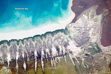
The bay has a very large tidal range which exposes around 160 km2 of mudflats, 45% of the total bay area, with the tide edge travelling at up to 20 cm per second. Most of the mudflats are inundated each high tide; spring tides or cyclones may also flood adjoining coastal flats. The tidal system is semi-diurnal with an average amplitude of 5.7 m, varying from 1 m on neap tides to 10.5 m on the highest spring tides. These tidal conditions dominate the intertidal ecology.[3]
History
Roebuck Bay lies in the traditional country of the Jukun and Yawuru Aboriginal peoples. The bay was important for seasonal meetings, exchanging gifts, arranging marriages and settling disputes. Many shellfish middens, marking former camping sites, are visible along the coastal cliffs and dunes. Indigenous people continue to make extensive use of the bay's natural resources by gathering shellfish, fishing and hunting.[2]
Dutch massacre
In 1941 several Dutch flying boats arrived with refugees from the Dutch East Indies. While laying at anchor in this bay they were attacked by Japanese Zero-fighter planes. The flying boats were defenceless and they were repeatedly attacked and sprayed with bullets from machine-guns. A hundred men, women and children were killed, many of them drowned; others were incinerated by the burning fuel on the surface of the water. The wrecks are still in situ, and several of them are visible a few days each year at extreme low tide.
On 7 June 1990 some 34,219 ha of the bay and its immediate surrounds were designated as a wetland of international importance, Ramsar Site 479, under the Ramsar Convention.[1]
Flora and fauna
Eleven mangrove species are found in Roebuck Bay.[3] The mangrove swamps that line the eastern and southern edges of the bay and extend into the tidal creeks are important nursery areas for marine fish and crustaceans, particularly prawns. Extensive seagrass beds across the bay are feeding grounds for Dugongs and Green Turtles. Other marine turtles and dolphins also regularly use the bay.[2]
Waders
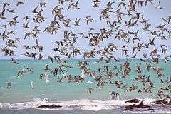
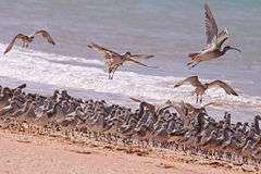
The intertidal mud and sand flats support high densities of benthic invertebrates, providing a key food source for waders or shorebirds. The site is one of the most important migration staging, and non-breeding, areas for waders in Australia and within the East Asian – Australasian Flyway. It is a principal spring arrival site in August–October for large proportions of the Australian populations of many species, and especially for the larger ones that travel non-stop from China to Australia. There is high turnover due to the birds moving onwards to south-western and south-eastern Australia, though large numbers remain through summer, and smaller numbers of non-breeding birds stay through winter. The area is also important for the northward movement of waders in autumn, with massed daytime departures taking place in March–April. The total number of waders using the bay each year is estimated to be over 300,000. The northern beaches of the bay, as well as Bush Point, provide important high tide roost sites.[2][3]
The bay's wader feeding habitats and roosting sites have been identified by BirdLife International as a 928 km2 Important Bird Area (IBA). The IBA also encompasses the low-lying, occasionally inundated, coastal grasslands to the east of the bay on Roebuck Plains Station, including Lake Eda, where many waders roost during very high tides.[4][5]
The bay regularly supports more than 1% of the population of at least 22 wader species: Greater sand plover, Lesser sand plover, Oriental plover, Red-capped plover, Grey plover, Bar-tailed godwit, Black-tailed godwit, Red knot, Great knot, Red-necked stint, Curlew sandpiper, Sanderling, Eastern curlew, Little curlew, Whimbrel, Common greenshank, Common redshank, Grey-tailed tattler, Terek sandpiper, Ruddy turnstone, Asian dowitcher, and Pied oystercatcher.[3]
Access and usage
Broome is a major tourist destination, and Roebuck Bay is used for recreational and tourism activities such as fishing, sightseeing and birdwatching. Broome Bird Observatory conducts shorebird research and public education.[2]
Transport and communications
Roebuck bay can be accessed by boat from Broome Wharf, approximately 9 kilometres south of Broome Post Office and Broome International Airport.
In the 1890s, Roebuck Bay was the terminus of a proposed but stillborn land grant railway from Angle Pole across the border in the Northern Territory.[6] This railway would have been about 1000 miles (1600 km) long.
Roebuck Bay, with its sheltered waters, was the site chosen for the undersea telegraph cable from Asia to come ashore in 1871, to continue overland to Perth.[7] This line is not to be confused with the Australian Overland Telegraph Line.
References
Notes
- 1 2 Annotated Ramsar List.
- 1 2 3 4 5 Protecting Ramsar Wetlands.
- 1 2 3 4 5 6 Information Sheet on Ramsar Wetlands.
- ↑ "IBA: Roebuck Bay". Birdata. Birds Australia. Retrieved 2011-10-01.
- ↑ BirdLife International. (2011). Important Bird Areas factsheet: Roebuck Bay. Downloaded from http://www.birdlife.org on 2011-10-01.
- ↑ "ANOTHER RAILWAY SYNDICATE.". South Australian Register. Adelaide: National Library of Australia. 14 February 1889. p. 6. Retrieved 11 April 2011.
- ↑ "INTERCOLONIAL.". The West Australian. Perth: National Library of Australia. 2 August 1890. p. 3. Retrieved 14 April 2011.
Sources
- "The Annotated Ramsar List: Australia". The Ramsar Convention on Wetlands. 4 January 2000. Retrieved 10 April 2010.
- "Information Sheet on Ramsar Wetlands: Roebuck Bay". Department of Conservation and Land Management, Western Australia. October 2003. Retrieved 11 April 2010.
- "Protecting Ramsar Wetlands. Site 3: Roebuck Bay" (PDF). Caring For Our Country. National Resource Management. Retrieved 11 April 2010.
External links
- Roebuck Bay at www.westernaustralia.com
Coordinates: 18°07′S 122°16′E / 18.117°S 122.267°E