Currawinya National Park
| Currawinya National Park Queensland | |
|---|---|
|
IUCN category II (national park) | |
 Currawinya National Park | |
| Nearest town or city | Hungerford |
| Coordinates | 28°39′S 144°24′E / 28.650°S 144.400°ECoordinates: 28°39′S 144°24′E / 28.650°S 144.400°E |
| Established | 1991 |
| Area | 1,513 km2 (584.2 sq mi) |
| Managing authorities | Queensland Parks and Wildlife Service |
| Website | Currawinya National Park |
| See also | Protected areas of Queensland |
Currawinya is a national park near Hungerford in South West Queensland, Australia, 828 km west of Brisbane. Part of the mulga lands bioregion this is an area of dry sandy plain with small trees and shrubs. The Paroo River passes through the park.
History
The park contains many Indigenous Australians' sites of cultural significance,[1] which indicate a long period of Aboriginal occupation and use of the wetlands within the park.[2] The park was previously pastoral land. In 1991, the Government of Queensland purchased two properties, Currawinya and Caiwarro Homestead.[2] Remains of the homestead, machinery and a levee bank still exist today.[1] In 2015, the size of the park doubled after the state government acquired three adjoining properties.[3]
Environment
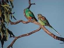
Lakes Numalla and Wyara within the park are listed as Ramsar wetland sites of international importance. Lake Numalla is freshwater while Lake Wyara is saline.[1] These provide significant waterbird habitats at times of drought and for migrating waders which travel across inland Australia.[2] 200 bird species have been recorded in the park.[4] Most of the park lies within the Paroo Floodplain and Currawinya Important Bird Area, identified as such by BirdLife International because of its importance, when conditions are suitable, for large numbers of waterbirds.[5]
A total of 14 threatened species have been identified within the park.[3]
Bilby enclosure
A feature of the park is a 25 square km bilby enclosure surrounded by a predator proof fence. The electrified enclosure was opened in 2001.[1] Captive bred and rehabilitated bilbies thrive within the safety of the enclosure. The fence was damaged by flooding in late 2011 and early 2012.[3] The broken fence allowed feral cats into the area. The cats proved difficult to cull and placed a hold on placing newly reared bilbies into the enclosure.[3]
Facilities
Fishing, canoeing and swimming are popular recreational activities in the park.[4]
See also
References
- 1 2 3 4 "Currawinya National Park: Nature, culture and history". Department of National Parks, Recreation, Sport and Racing. 3 March 2014. Retrieved 7 September 2014.
- 1 2 3 Environmental Protection Agency (Queensland) (2002). Heritage Trails of the Queensland Outback. State of Queensland. p. 113. ISBN 0-7345-1040-3.
- 1 2 3 4 Tom Forbes (16 June 2015). "Currawinya National Park size doubled to help endangered bilbies, Queensland Government says". ABC News. Australian Broadcasting Corporation. Retrieved 15 July 2015.
- 1 2 "Currawinya National Park". Tourism Queensland. Retrieved 24 October 2010.
- ↑ "IBA: Paroo Floodplain & Currawinya". Birdata. Birds Australia. Archived from the original on 6 July 2011. Retrieved 2011-09-13.