Rohri
| Rohri روهڙي | |
|---|---|
| City | |
|
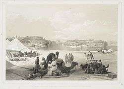
A historic image of Rohri - Sukkur | |
 Rohri | |
| Coordinates: 27°40′59″N 68°54′00″E / 27.68306°N 68.90000°ECoordinates: 27°40′59″N 68°54′00″E / 27.68306°N 68.90000°E | |
| Country | Pakistan |
| Province | Sindh |
| District | Sukkur |
| Union Councils | 11 |
| Government | |
| • Type | Town Council |
| Area[1] | |
| • Total | 1,319 km2 (509 sq mi) |
| Elevation | 62 m (203 ft) |
| Population (2002)[1] | |
| • Total | 224,362 |
| • Density | 170/km2 (440/sq mi) |
| Time zone | PST (UTC+5) |
Rohri (Sindhi:روهڙي), (Urdu: روہڑی), (medievally Aror) is a town of Sukkur District, Sindh province, Pakistan. It is located on the east bank of the Indus River. Rohri town is the administrative headquarters of Rohri Taluka, a tehsil of Sukkur District[2] with which it forms a metropolitan area.
History
Aror was the ancient capital of Sindh, ruled by the Ror Dynasty. Modern Rohri is situated adjacent to Sukkur, Sindh. In 711, Aror was captured by the army of Muslim general Muhammad Bin Qasim. In 962 it was hit by a massive earthquake that changed the course of the Indus River.
Climate
Rohri has a hot desert climate (Köppen climate classification BWh) with extremely hot summers and mild winters. Rohri is very dry, with the little rain it receives mostly falling in the monsoon season from July to September.
| Climate data for Rohri | |||||||||||||
|---|---|---|---|---|---|---|---|---|---|---|---|---|---|
| Month | Jan | Feb | Mar | Apr | May | Jun | Jul | Aug | Sep | Oct | Nov | Dec | Year |
| Record high °C (°F) | 30.6 (87.1) |
37.2 (99) |
42.2 (108) |
47.0 (116.6) |
49.0 (120.2) |
50.0 (122) |
47.0 (116.6) |
47.0 (116.6) |
43.3 (109.9) |
43.3 (109.9) |
38.0 (100.4) |
31.1 (88) |
50 (122) |
| Average high °C (°F) | 22.8 (73) |
25.3 (77.5) |
31.2 (88.2) |
37.6 (99.7) |
42.4 (108.3) |
43.6 (110.5) |
40.8 (105.4) |
38.7 (101.7) |
38.0 (100.4) |
35.3 (95.5) |
29.9 (85.8) |
24.0 (75.2) |
34.13 (93.43) |
| Daily mean °C (°F) | 15.6 (60.1) |
18.1 (64.6) |
23.8 (74.8) |
29.8 (85.6) |
34.3 (93.7) |
36.0 (96.8) |
34.4 (93.9) |
32.7 (90.9) |
31.4 (88.5) |
27.8 (82) |
22.5 (72.5) |
16.8 (62.2) |
26.93 (80.47) |
| Average low °C (°F) | 8.4 (47.1) |
10.9 (51.6) |
16.4 (61.5) |
22.0 (71.6) |
26.2 (79.2) |
28.4 (83.1) |
27.9 (82.2) |
26.7 (80.1) |
24.9 (76.8) |
20.3 (68.5) |
14.4 (57.9) |
9.6 (49.3) |
19.68 (67.41) |
| Record low °C (°F) | 1.7 (35.1) |
1.0 (33.8) |
5.0 (41) |
10.0 (50) |
16.0 (60.8) |
19.0 (66.2) |
17.5 (63.5) |
17.5 (63.5) |
16.5 (61.7) |
9.5 (49.1) |
5.5 (41.9) |
−1.5 (29.3) |
−1.5 (29.3) |
| Average precipitation mm (inches) | 3.5 (0.138) |
8.0 (0.315) |
5.7 (0.224) |
1.5 (0.059) |
4.0 (0.157) |
4.3 (0.169) |
25.7 (1.012) |
19.8 (0.78) |
10.0 (0.394) |
1.3 (0.051) |
0.6 (0.024) |
3.8 (0.15) |
88.2 (3.473) |
| Source: NOAA (1961-1990) [3] | |||||||||||||
External links
References
- 1 2 "Sukkur's History". Sukkur District Government. Retrieved 2007-11-28.
- ↑ Taluka Municipal Administration Rorhi
- ↑ "Rohri Climate Normals 1961-1990". National Oceanic and Atmospheric Administration. Retrieved January 17, 2013.