Roseires Dam
| Roseires Dam | |
|---|---|
 | |
| Location | Ad Damazin, Sudan |
| Coordinates | 11°47′53″N 34°23′15″E / 11.79806°N 34.38750°ECoordinates: 11°47′53″N 34°23′15″E / 11.79806°N 34.38750°E |
| Construction began | 1961 |
| Opening date | 1966 |
| Dam and spillways | |
| Height | 78 m (256 ft) |
| Length | 24,410 m (80,090 ft) |
| Reservoir | |
| Total capacity | 7.4 km3 (5,999,278 acre·ft) |
| Surface area | 29,000 ha (71,661 acres) |
| Power station | |
| Installed capacity | 1,800 MW |
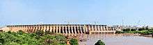
The Roseires Dam (Arabic: خزان الروصيرص) is a dam on the Blue Nile at Ad Damazin, just upstream of the town of Er Roseires, in Sudan. It consists of a concrete buttress dam 1 km wide with a maximum height of 68m, and an earth dam on either side. The earth dam on the eastern bank is 4 km long, and that on the western bank is 8.5 km long. The reservoir is about 290 km2.
The dam was completed in 1966, initially for irrigation purposes. A power generation plant, with a maximum capacity of 280 megawatts, was added in 1971. A heightening (and lengthening) project was completed in 2013 and the dam is now 25 km long.[1]
References
External links
- Sudan Government: Dams Implementation Unit
- Sudan, Electric power. Library of Congress
- Africa Dams Briefing 2010 - International Rivers p. 54
- Vintage Project Management - The tamers of rivers 1966
This article is issued from Wikipedia - version of the 11/13/2016. The text is available under the Creative Commons Attribution/Share Alike but additional terms may apply for the media files.